Grundlagen Fernerkundung - 14
|
|
|
- Juliane Schubert
- vor 6 Jahren
- Abrufe
Transkript
1 Grundlagen Fernerkundung - 14 Wrap up GEO123.1, FS2015 Michael Schaepman & Hendrik Wulf, 5/22/15 Page 2


2 Department of Geography Fernerkundung!! ist das berührungsfreie Messen und Interpretieren von reflektierter oder emittierter elektromagnetischer Strahlung.! umfasst die gesamte Erdoberfläche einschließlich der Erdatmosphäre.! wird durch satelliten-, flugzeug-, dronen- und handgetragende Sensoren (Kameras und Scanner) ermöglicht.
.")
3 Systeme & Anwendungen Bei der Fernerkundung finden passive oder aktive Systeme Verwendung. Passive Systeme zeichnen die von der Erdoberfläche reflektierte Sonnenstrahlung auf sowie die von der Erdoberfläche emittierte Eigenstrahlung (z.b. Thermalkamera). Im Gegensatz dazu senden aktive Systeme Mikrowellen- oder Laserstrahlen aus und empfangen deren reflektierte Anteile (z.b. Radarsysteme und Laseraltimeter). Fernerkundungsdaten sind insbesondere in den Geowissenschaften/ Geographie von großer Bedeutung, da eine globale Beobachtung der Erdoberfläche/Atmosphäre in hoher räumlicher Auflösung nur mit Hilfe von Fernerkundungssensoren möglich ist. Neben dem synoptischen Überblick über große Räume ermöglichen satellitengestützte Fernerkundungssensoren zudem eine wiederholte (zum Teil tägliche) Abdeckung ein und desselben Gebietes.
4 Strahlungspfade der Fernerkundung
5 Strahlungskomponenten an einem Sensor L s E 0 L atm L gnd " d " u L g,adj L g,dir E dif E gnd!


6 Das elektromagnetische Spektrum < 0.3 µm Ultraviolet / UV 0.4 µm 0.5 µm blue / VIS 0.5 µm 0.6 µm green / VIS 0.6 µm 0.7 µm red / VIS 0.7 µm 1.3 µm near IR / NIR 1.3. µm 3 µm shortwave IR / SWIR 3 µm 14 µm thermal IR / TIR 1 mm 1 m microwave

7 Solar radiation spectrum Solarkonstante W/m 2

8 Räumliche, spektrale und zeitliche Auflösung
9 Spektralbereiche und Systeme Überblick über Fernerkundungssensoren und Systeme System Spektralbereich Photographische Kameras UV NIR Solid State Kameras VIS IR Multispektralscanner UV IR Abbildende Spektrometer VIS IR Radiometer UV MW Radar, SAR MW Lidar VIS NIR Sonar Audiowellen

10 Spektrale Auflösung

11 Die atmosphärische Interaktion 4 Typen der Streuung der Strahlung in der Atmosphäre - Rayleigh Streuung - Raman Streuung - Mie Streuung - unselektive Streuung

12 Definition des räumlichen Referenzsystems
13 Spekulare und diffuse Reflektanz
14 Geometrische Effekte, die eine Veränderung der Reflektanz zur Folge haben


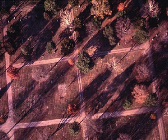

15 Direktionale Effekte 09:58 13:40 17:12

16 Department of Geography Komponenten einer auf ein Laubblatt eintreffenden Strahlung
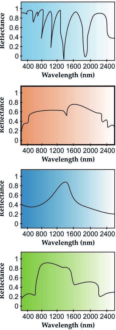
17 Charakteristische Reflexionskurve eines grünen Blattes
18 Reflexionskurven für Blätter mit unterschiedlichem Wassergehalt


19 Characterizing Land Surface Processes Temporal! Photos: M. Kneubühler ! ! !!!!!!!! ! ! !!!!!!!! ! ! !

20 Characterizing Land Surface Processes Spectral! Daten: M. Kneubühler
21 Imaging Spectroscopy In literature, the terms imaging spectroscopy, imaging spectrometry, hyperspectral, superspectral, and ultraspectral imaging are often used interchangeably. Even though semantic differences might exist, a common definition is: " Imaging spectrometry is the simultaneous acquisition of spatially coregistered images, in many, spectrally contiguous bands, measured in calibrated radiance units, from a remotely operated platform. " Imaging spectroscopy is the simultaneous acquisition of spatially coregistered images, in many, spectrally contiguous bands, measured as reflectance, from a remotely operated platform.
3345'6./07&%'()5',89:';/2<=>>?")
22 Image Cube

23 Data cube Spectral information
\" Frame")
\"")

24 Data Acquisition a)" Film camera b)" Frame camera c)" Scanner d)" Pushbroom imager e)" Whiskbroom imager f)" Pushbroom imaging spectrometer
25 Begriffe Mikrowellen: Elektromagnetische Wellen - Wellenlängen:1 m - 1 mm - Frequenzen: 300 MHz GHz Radiometer: Instrument zur (passiven) Messung elektromagnetischer Strahlung - Imager: Bildgebender passiver Sensor - Sounder: Instrument zur Messung von Profilen Radar: RAdio Detection And Ranging - aktives System, Detektion und Distanzmessung - SAR: Synthetic Aperture Radar - SLAR: Side-Looking Airborne Radar - Altimeter: Höhenmessung (nicht abbildend) - Scatterometer: Messung der Rückstreuung (nicht abbildend) Sonar: SOund Navigation And Ranging - Aktives System analog zu Radar, arbeitet mit Schallwellen
26 Strahlengang bei einem passiven Mikrowellen- System
27 Ursprung von passiven Mikrowellenstrahlen Emitted from object:!" z.b. Wärme-Abgabe, radioaktive Strahlung, Sonnenenergie Emitted by atmosphere:!" z.b. Polarlicht, chemische Prozesse wie Ozon-Abbau Reflected from Surface:!" Sonnenenergie Transmitted from subsurface:!" Erdstrahlen, radioaktive Strahlung, elektromagnetische Wellen hervorgerufen durch seismische Phänomene
28 Summary: Passive Microwaves Applications Oceans:!" Sea Surface Temperature & Salinity!" Sea Ice!" Surface wind velocities Land:!" Soil moisture!" Snow melt & water equivalent Atmosphere:!" Water vapor
 und somit Zeit (Tag/Nacht)!")
29 Aktive Mikrowellen - Fernerkundung Aktive Sensoren!" Radar!" Altimeter!" Scatterometer!" SLAR / SAR (abbildend) Quelle der Strahlung!" System selber Vorteile!" Unabhängig von Beleuchtung (Sonne) und somit Zeit (Tag/Nacht)!" System-Design (Art der Quellstrahlung) ist definierbar
30 Aktive Mikrowellen - Fernerkundung Systeme mit realer Apertur (Real Aperture Radar RAR) Systeme mit synthetischer Apertur Tracking Radars Altimeter Scatterometer SLAR Side-Looking Airborne Radar Abbildende Verfahren SAR Synthetic Aperture Radar


31 Aktive Mikrowellensysteme: Seitensichtradar
32 Konzept-Vergleich: Synthetischen vs. Reale Apertur Ein Radar mit synthetischer Apertur erlaubt eine sehr gute Auflösung in Flugrichtung (Bewegungsrichtung des Sensors). Dies wird durch synthetisches Zusammenfügen vieler Radarechos erreicht, welche ein Objekt aus verschiedenen Winkeln zeigen.


33 Vergleich SLAR- vs. SAR Gurnigel, BE Gute Auflösungen in beiden Bilddimensionen Bilder RSL / Fraunhofer FHR
34 Effekte der Geländegeometrie auf das SAR- Radarbild III University of California, Santa Barbara


35 Reflexionseigenschaften und Eindringtiefen Volumen-Streuung volume scattering Doppelreflexion double bounce Oberflächen-Streuung Surface scattering
36 Begriffe LiDAR: Light Detection And Ranging - aktives System analog zu RADAR - funktioniert im UV, VIS, IR Bereich - primäre Anwendung: Distanzmessung Laser: Light Amplification by Stimulated Emission of Radiation - hohe Intensität, enger Frequenzbereich, grosse Koheränzlänge ALS: Airborne Laser Scanning - flugzeug oder helikoptergestütztes System - Erstellung von Gelände und Oberflächenmodellen
37 LiDAR & Laser Scanning - Unterschiede LiDAR - nur Distanzmessung topographic LiDAR - Distanzmessung + Position/Ausrichtung zur Bestimmung einer Koordinate, profilierender LiDAR (z.b. GLAS, SLICER) (Airborne) Laser Scanning (ALS) - Distanzmessung + Position/Ausrichtung + Scanner, zur Strahlablenkung quer zur Flugrichtung, Abdeckung eines Schwates d.h. ein LiDAR ist Teil eines ALS, aber nicht das Gleiche!


38 Messprinzip III Range First Echo Full waveform Intensity Last Echo


39 Department of Geography Oberflächen- und Terrain-Modelle Digitales Geländemodell (DGM) Digitales Oberflächenmodell (DOM) 40
40 Anwendungsbeispiele GIS Orthorektifizierung von Luftbildern Infrastruktur und Planung Gefahren- und Risikomanagement Forstwesen... Referenzdaten fuer die SAR-Geokodierung Überall dort wo eine präzise Modellierung der Erdoberfläche benötigt wird
41 Anwendungsbeispiele Messung der Ozonkonzentration in... "... bodennahen Luftschichten "... der Stratosphäre Detektion von Aerosolen Detektion von Wasserdampf, Stickstoff und Schwefelverbindungen Windmessungen (Doppler - LiDAR)


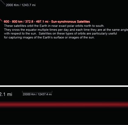

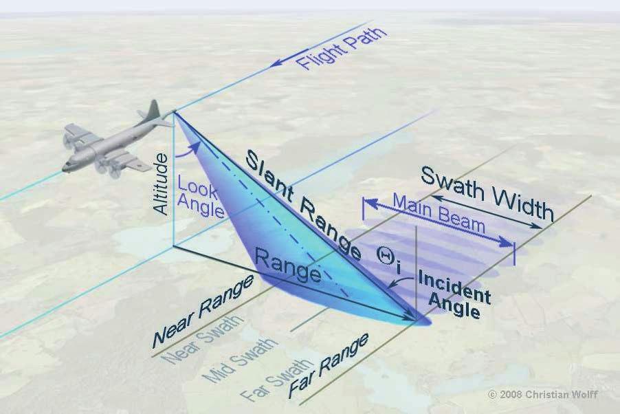
42 Satellite Orbits 5/22/15 Page 43
43 Terms & Definitions: Orbits Inclination: orbit angle with respect to the equator " near polar orbit = close to 90 " equatorial orbit = 0!"#$#%&'!"!"#$!%&'()*"&%!"&"'+%!&,-+.'/"& " #$%&'(')%*(+,"%+-)'!".(/"012333"45" " &6*7&,*.8+%*%6&!"9337:33"45" (')$*&!"%#0"&%)&/)012"%"&)3"&)+(#%&45 ) 6& " ;(*<&('!"=3>"45?"@:/@"5)*A%+-)'?"B9/>"+$C%D6')%*&"E$+"<(," " FGG!"933"45?"@H/:"5)*A%+-)'?"B>/9"+$C%D6')%*&"E$+"<(," +,%-#*)$-"./)*00$12.#$3'!" " #$*$+(DD,"-$'I$$*"B3"(5"(*<"H"E5 5/22/15 Page 44
44 Terms & Definitions: Sensor characteristics Spatial resolution: ground surface area represented by one pixel " Instantaneous field of view (IFOV) " Ground sampling distance (GSD) Temporal resolution: time between two image acquisitions for a given location " Revisit time or repeat cycle (measured in days) Spectral resolution: number of spectral bands and their wavelength intervals " Panchromatic, multispectral, imaging spectroscopy Radiometric resolution: effective bit-depth of the sensor " Gain settings: range of brightness sensitivity " Signal to noise ratio 5/22/15 Page 45

45 Landsat 8 (Landsat Data Continuity Mission) " Launched: February 11, 2013 " Scientific goal: Characterize and monitor land-cover use and change over time " Applications: Carbon Cycle, Earth Surface, Ecosystems, and Biogeochemistry " Sensors: Operational Land Imager Thermal Infrared Sensor " Data: for the general public (no costs)


46 Department of Geography Landsat 7: Spectral bands µm µm µm µm µm µm µm
 \" Scientific goal: provide measurements of large-scale global dynamics \" Applications: cloud cover, radiation budget and oceanic terrestrial and lower atmospheric processes \" Sensor:")
47 Department of Geography MODIS (Moderate Resolution Imaging Spectroradiometer) " Launched: December 18, 1999 (1st of 2 sat.) " Scientific goal: provide measurements of large-scale global dynamics " Applications: cloud cover, radiation budget and oceanic terrestrial and lower atmospheric processes " Sensor: multispectral radiometer " Data: for the general public (no costs)


48 MODIS products overview Surface temperature (land and ocean) and fire detection; " " " " " " Ocean color, currents; Global vegetation and change maps; Cloud characteristics; Aerosol concentrations and properties; Temperature and moisture soundings; Snow cover and characteristics; 5/22/15 Page 49

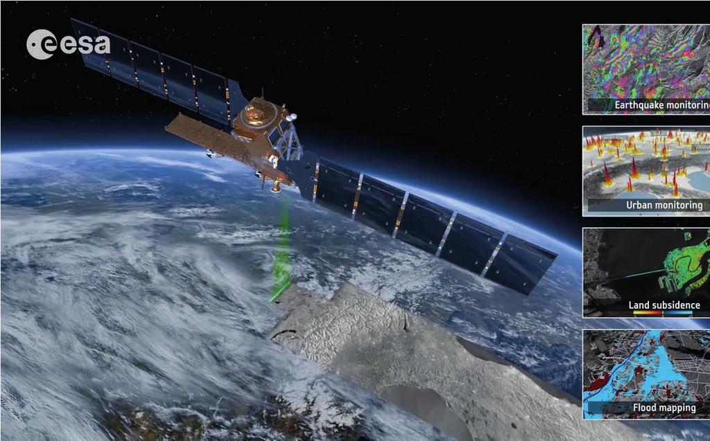
49 Department of Geography ESA s Earth Observation Programme 5/22/15 Page 50

50 MERIS! ASAR! GOMOS! AATSR! MEdium Resolution Imaging Spectrometer! Advanced Synthetic Aperture Radar! Global Ozone Monitoring by Occultation of Stars! Advanced Along Track Scanning Radiometer! RA-2! Radar Altimeter 2! SCIAMACHY! MIPAS! MWR! LRR! DORIS! SCanning Imaging Absorption SpectroMeter for Atmospheric CartograpHY! Michelson Interferometer for Passive Atmospheric Sounding! MicroWave Radiometer! Laser RetroReflector! Doppler Orbitography and Radiopositioning Integrated by Satellite!

51 ESA s Earth Explorers Objective: Better understanding of Earth Science in various fields of interest based on innovative satellite technology Satellit GOCE SMOS Ziel der globalen Forschungen Bestimmung des Erdschwerefeldes Bodenfeuchte, Salzgehalt der Meere Start CryoSat Erfassung der planetaren Eismassen SWARM Erdmagnetfeld und Klima ADM-Aeolus Dynamik der Erdatmosphäre 2015 (geplant) EarthCARE Wolken und Aerosole 2016 (geplant) Biomass Biomasse der Wälder 2020 (geplant)


52 Department of Geography VHR satellite imagery - Applications Defense & Security Oil, Gas, Mining Civil Engineering Agriculture Mapping & 3D Forest & Environment Disasters & Crisis Culture & Heritage
 ISRO 2007-2010 GeoEye-1 GeoEye 2008 Pleiades (2x) CNES 2011-2012 Skysat 1-2 (15x) Skybox Imaging")
53 Very high resolution satellites Satellite Organization Launch date IKONOS GeoEye 1999 Quickbird (3x) DigitalGlobe WorldView-1, 2, 3 DigitalGlobe 2007, 2009, 2014 Cartosat-2 (2x) ISRO GeoEye-1 GeoEye 2008 Pleiades (2x) CNES Skysat 1-2 (15x) Skybox Imaging


54 Copernicus pillars Department of Geography European independence & contribution to global observing system Space Component Global, timely and easily accessible information In-Situ Component 5/22/15 Services Component Page 55
55 The Sentinel Family Sentinel 1 SAR imaging All weather, day/night applications, interferometry 2014 / 2015 Sentinel 2 Multi-spectral imaging Land applications: urban, forest, agriculture,.. Continuity of Landsat, SPOT 2015 / 2016 Sentinel 3 Ocean and global land monitoring Wide-swath ocean color, vegetation, sea/land surface temperature, altimetry 2015 / 2017 Sentinel 4 Geostationary atmospheric Atmospheric composition monitoring, transboundary pollution 2020 Sentinel 5 / 5P Low-orbit atmospheric Atmospheric composition monitoring (S5 Precursor launch in 2015) 2015, 2021

56 Department of Geography Spectral bands: Sentinel-2 vs. Landsat-8
57 Sentinel-1 applications: (1) Land 5/22/15 Page 58

58 Sentinel-1 applications: (2) Sea 5/22/15 Page 59

59 Sentinel-2 applications Agriculture, Forestry and Range!" e.g. discriminating vegetation type & state Land Use/Cover Changes!" e.g. monitoring urban growth Geology!" e.g. mapping geologic landforms Hydrology!" e.g. determining snow and ice cover Coastal Resources!" e.g. tracking shoreline erosion and flooding Environmental Monitoring!" e.g. monitoring deforestation 5/22/15 Page 60


60 Sentinel-3 applications Marine and Coastal Environment!" e.g. Sea-surface topography & temperature, circulation, water quality, wave height Polar Environment!" e.g. Sea-ice thickness Global Change Ocean!" e.g. Sea-level rise, CO 2 flux Land Cover & Land-Use Change!" e.g. Forest monitoring, land-use mapping Risk Management!" e.g. Fire detection, Burnt area mapping 5/22/15 Page 61

61 Lillesand Fig Department of Geography Histogram or Contrast stretching DR sensor (0-255) DR display (0-255) DR sensor (60-158) DR display (0-255)


62 Level slicing " " " Discontinuous color mapping Subdividing the continuous range of values into discontinuous but sequential groups (called bins or classes) Simplest way of making classes based on spectral values 0 10 aquamarine sienna dark green color scale light green to white


63 Band combinations Each spectral band represents a grey-scale image. Three of these bands can be assigned to the display colors red (R), green (G) and blue (B) to obtain a full-color image. 3 bands, each = 24 bit color depth (16.7 million colors) blue green red


64 False-color images using 7 Landsat bands Landsat bands "m Blue "m Green "m Red "m Near IR "m Mid-IR "m Thermal IR "m Mid-IR


65 Maximizing spectral contrast Green, dense For vegetation:! Brown or sparse " Reflectance is highest in NIR and Red Infrared Red Infrared lowest in RED! " The ratio NIR / RED gives therefore the highest contrast and the best way to quantify changes! " This ratio changes under stress!!!

66 Spatial Image Filtering " " " Filtering manipulates the image elements Filters are applied using kernels composed of size and weights Most common in image analysis: high-pass and low-pass filters
 negative weights; sum is 0 or higher Special case: Laplacian (2 nd derivative) filter 0-1 0-1 5-1 0-1")
67 High-pass filter (sharpening) " " " " Used to enhance high-frequency variations Disadvantage: enhances noise as well Kernel typically has high central value surrounded by (partially) negative weights; sum is 0 or higher Special case: Laplacian (2 nd derivative) filter
68 Low-pass filter (smoothing) " " " " Used to suppress high-frequency variation and noise Kernel with small positive values. Simplest case: all values (1 / kernel size) and thus sum equals 1 Kernel size (3x3, 5x5,!) determines degree of smoothing Special case: Gaussian filter (or Gaussian blur ) 1/9 1/9 1/9 1/9 1/9 1/9 1/9 1/9 1/9
.")
69 Classification methods Albertz, 2001 Unsupervised classification Supervised classification Clustering, (Segmentation)... Parallelepiped, Minimum distance, Maximum likelihood...
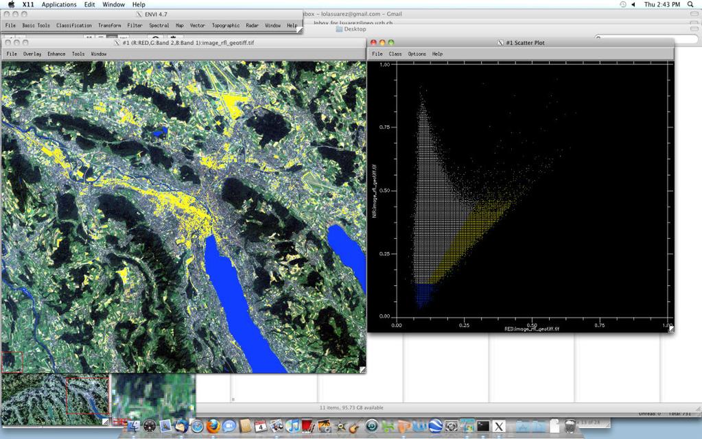
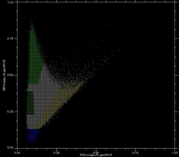
70 Department of Geography Feature space: NIR vs RED
71 Common classification algorithms: overview Parallelepiped Minimum Distanz Maximum Likelihood
72 Type 1 (commission) and type 2 (omission) error Referenz/ ground truth Klassifikation Klassifikation Referenz/ ground truth A B C D " A B C D " Incorrectly classified classification # reference -" Type 1: Commission Error Pixels were included in the class, although they should not have been -" Type 2: Omission Error Pixels were not included in the class, although they should have been
73 Producer s Accuracy (PA) Referenz/ ground truth A B C D " Klassifikation Klassifikation A B C The producer needs to know how well her/his classification (e.g. for class A) matches with the reference Referenz D " PA == Omission Error How many pixels should have been in the class but were not Producer s Accuracy = count of correctly classified pixels in class count of pixels in same reference class = = (~83.3%)
74 User s Accuracy (UA) Referenz/ ground truth A B C D " UA Klassifikation Klassifikation A B C The user needs to know how well a class (e.g. A) matches with the reality Referenz D " == Commission Error How many pixels are in the class but should not have been User s Accuracy = count of correctly classified pixels in class count of all pixels in that class = = 1 (100%)
75 Overall/ Total Accuracy (OA) Referenz/ ground truth A B C D " A Klassifikation Klassifikation B C D Referenz " Overall Accuracy = Count of correctly classified pixels Grand total (total pixel count) = = (~90.6%)
![Accuracy metrics OA, PA, UA Referenz/ ground truth A B C D " UA [%] A 15 0 0 0 15 100 If I classified a pixel as forest (A), there is in](/docs-images/75/72560817/images/76-2.jpg "100% of the cases indeed forest at that location Klassifikation Klassifikation B 0 9 0 0 9 100 C 3 1 24 2 30 80 I have captured 100% of")
 pixels has another land cover in reality PA [%] 83.33 90 100 83.33 OA [%] 90.63 But: 16.")
76 Accuracy metrics OA, PA, UA Referenz/ ground truth A B C D " UA [%] A If I classified a pixel as forest (A), there is in 100% of the cases indeed forest at that location Klassifikation Klassifikation B C I have captured 100% of the existing arable land (C) with my classification Referenz D " But: 20% of the classified arable land (C) pixels has another land cover in reality PA [%] OA [%] But: 16.67% of the existing forest (A) was not captured


77 Department of Geography Radialdeformation Image taken on Sept. 23, 2001 from an altitude of 3,300 feet using a Leica/LH systems RC30 camera

78 Zentralperspektive und orthogonale Kartenprojektion Quelle: Bundesamt für Landestopographie swisstopo und Grundlagen Luftbildmessung 2
79 Stereoskopische Parallaxe und Höhenmessung b g Flugbasis h g Flughöhe über Grund H 1, H 2 Bildhauptpunkt R Kopfpunkt Objekt S Fusspunkt Objekt ps=ps 1 +ps 2 Absolute Parallaxe für S #p 1, #p 2 Parallaxdifferenz Objekt, LB1, 2 #p=#p 1 +#p 2 Parallaxdifferenz im Luftbildpaar b p Photobasis f Brennweite #h Objekthöhe R 1, R 2 Kopfpunkt im Luftbild 1, 2 S 1, S 2 Fusspunkt im Luftbild 1, 2 pr 1, pr 2 Absolute Parallaxe für R #P Parallaxdifferenz in der Bezugsebene S (Gelände) Parallaxe für R: pr = pr 1 -pr 2 Parallaxe für S: ps = ps 1 -ps 2 Parallaxedifferenz #p: pr-ps #h=(#p*h g )/pr
Grundlagen Fernerkundung - 5
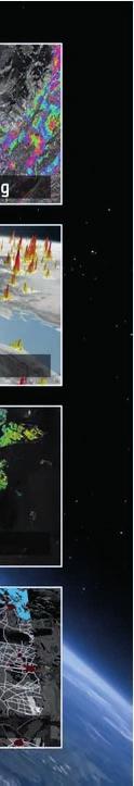
 Grundlagen Fernerkundung - 5 GEO123.1, FS2015 Michael Schaepman, Erich Meier, Hendrik Wulf 3/11/15 Page 1 Aqua / MODIS - Image NASA Aqua / MODIS - Image NASA NOAA-17 / AVHRR Image NOAA Envisat / MERIS
Grundlagen Fernerkundung - 2
 Grundlagen Fernerkundung - 2 GEO123.1, FS2015 24. 2. 2015 Michael Schaepman, Hendrik Wulf 2/19/15 Page 1 http://earthobservatory.nasa.gov Department of Geography 2/19/15 Page 2 Department of Geography
FFG Austrian Research Promotion Agency Agentur für Luft- und Raumfahrt
 FFG Austrian Research Promotion Agency GMES - Eine Chance für Österreichs Forschung und Industrie H. Posch 5 Dezember 2006 GMES - Hauptelemente Space Component wird unter ESA Verantwortung abgewickelt
Using TerraSAR-X data for mapping of damages in forests caused by the pine sawfly (Dprion pini) Dr. Klaus MARTIN klaus.martin@slu-web.
 Dr. Klaus MARTIN klaus.martin@slu-web.") Using TerraSAR-X data for mapping of damages in forests caused by the pine sawfly (Dprion pini) Dr. Klaus MARTIN klaus.martin@slu-web.de Damages caused by Diprion pini Endangered Pine Regions in Germany
Using TerraSAR-X data for mapping of damages in forests caused by the pine sawfly (Dprion pini) Dr. Klaus MARTIN klaus.martin@slu-web.de Damages caused by Diprion pini Endangered Pine Regions in Germany
Applying Pléiades in the ASAP project HighSens
 Applying Pléiades in the ASAP project HighSens Highly versatile, new satellite Sensor applications for the Austrian market and International Development (Contract number: 833435) Dr. Eva Haas, GeoVille
Lufft UMB Sensor Overview
 Lufft Sensor Overview Wind Radiance (solar radiation) Titan Ventus WS310 Platinum WS301/303 Gold V200A WS300 WS400 WS304 Professional WS200 WS401 WS302 Radiance (solar radiation) Radiation 2 Channel EPANDER
Das Copernicus Sentinel Satellitenprogramm. Neue Anwendungsmöglichkeiten für die Erdbeobachtung
 Das Copernicus Sentinel Satellitenprogramm Neue Anwendungsmöglichkeiten für die Erdbeobachtung Prof. Dr. Günter Strunz Deutsches Zentrum für Luft- und Raumfahrt (DLR) Oberpfaffenhofen Vortrag im Rahmen
Satellitenbilddaten und Datenquellen
 armasuisse Satellitenbilddaten und Datenquellen Tobias Kellenberger (swisstopo) tobias.kellenberger@swisstopo.ch 23. Juni 2009, Universität Zürich-Irchel Übersicht! Aktuelle und neue kommerzielle ( Satelliten-)
Satellitenmeteorologie
 Eidgenössisches Departement des Innern EDI Bundesamt für Meteorologie und Klimatologie MeteoSchweiz Satellitenmeteorologie EUMETSAT, ESA/Ducros Bundesamt für Meteorologie und Klimatologie MeteoSchweiz
JPlus Platform Independent Learning with Environmental Information in School
 JPlus Platform Independent Learning with Environmental Information in School Mario Härtwig, Pierre Karrasch Salzburg, 7. Juli 2010 Genesis Umweltmonitoring als Beitrag zur Umweltbildung an Schulen. Kulturlandschaftsentwicklung
Hyperspektral in Oberpfaffenhofen: Das EnMAP Bodensegment und die CHB
 Hyperspektral in Oberpfaffenhofen: Das EnMAP Bodensegment und die CHB Karim Lenhard, Jochen Fries, Birgit Suhr, Peter Gege (CHB) Andreas Müller, Tobias Storch, Armin Braun, Helmut Mühle, Rupert Müller
Grundlagen und Verfahren der Luftbild Photogrammetrie
 Grundlagen und Verfahren der Luftbild Photogrammetrie Grundvorlesung in den Studiengängen Vermessung (3. Semester) und Geoinformatik (5. Semester) HS BO Lab. für Photogrammetrie: Grundlagen und Verfahren
Meteorological measurements at the Offshore Platform FINO 2 - new insights -
 FINO 2011 Conference May 11 th 2011, Hamburg, Germany Meteorological measurements at the Offshore Platform FINO 2 - new insights - Dipl.-Geoök. Stefan Müller, Dipl.-Ing Joachim Schwabe Content 1. FINO
7 Prozesse in der Fernerkundung
 7 Prozesse in der Fernerkundung Beleuchtungsquelle (elektromagnetische Energie) Sensor Wechselwirkung mit der Atmosphäre Interpretation/ Analyse Objekt (elektromagnetische Observablen) Empfangsstation
HIR Method & Tools for Fit Gap analysis
 HIR Method & Tools for Fit Gap analysis Based on a Powermax APML example 1 Base for all: The Processes HIR-Method for Template Checks, Fit Gap-Analysis, Change-, Quality- & Risk- Management etc. Main processes
VGM. VGM information. HAMBURG SÜD VGM WEB PORTAL - USER GUIDE June 2016
 Overview The Hamburg Süd VGM-Portal is an application which enables to submit VGM information directly to Hamburg Süd via our e-portal web page. You can choose to insert VGM information directly, or download
Pilot Project Biogas-powered Micro-gas-turbine
 1/18 Pilot Project Biogas-powered Micro-gas-turbine Supported by the Hessischen Ministerium für Wirtschaft, Verkehr und Landesentwicklung Speaker Details 2/18 Jan Müller Works at Institute of Solar Energy
Mitglied der Leibniz-Gemeinschaft
 Methods of research into dictionary use: online questionnaires Annette Klosa (Institut für Deutsche Sprache, Mannheim) 5. Arbeitstreffen Netzwerk Internetlexikografie, Leiden, 25./26. März 2013 Content
Geometrie und Bedeutung: Kap 5
 : Kap 5 21. November 2011 Übersicht Der Begriff des Vektors Ähnlichkeits Distanzfunktionen für Vektoren Skalarprodukt Eukidische Distanz im R n What are vectors I Domininic: Maryl: Dollar Po Euro Yen 6
CONCEPTS FOR SPACE-BORNE AND GROUND-BASED RADAR SYSTEMS FOR TSUNAMI DETECTION
 CONCEPTS FOR SPACE-BORNE AND GROUND-BASED RADAR SYSTEMS FOR TSUNAMI DETECTION : 10.-12. Oct. 2006 Marquart Galletti Börner Krieger Schulz-Stellenfleth Contents GITEWS project Motivation (Boxing Day Tsunami)
Workflows, Ansprüche und Grenzen der GNSS- Datenerfassung im Feld
 Workflows, Ansprüche und Grenzen der GNSS- Datenerfassung im Feld Alexander Fischer Senior Application Engineer Asset Collection & GIS 1 Leica Zeno GIS Agenda Erfassung im Feld VS Erfassung im Office Validierung
GMES Integrated Application Promotion (IAP)
") GMES Integrated Application Promotion (IAP) AHORN 2008 Salzburg 20. November 2008 Dr. Thomas Geist GMES was ist das? Global Monitoring for Environment and Security Eine gemeinsame strategische Initiative
GMES Integrated Application Promotion (IAP) AHORN 2008 Salzburg 20. November 2008 Dr. Thomas Geist GMES was ist das? Global Monitoring for Environment and Security Eine gemeinsame strategische Initiative
Efficient Design Space Exploration for Embedded Systems
 Diss. ETH No. 16589 Efficient Design Space Exploration for Embedded Systems A dissertation submitted to the SWISS FEDERAL INSTITUTE OF TECHNOLOGY ZURICH for the degree of Doctor of Sciences presented by
GRIPS - GIS basiertes Risikoanalyse-, Informations- und Planungssystem
 GRIPS - GIS basiertes Risikoanalyse-, Informations- und Planungssystem GIS based risk assessment and incident preparation system Gregor Lämmel TU Berlin GRIPS joined research project TraffGo HT GmbH Rupprecht
Fundamentals of Electrical Engineering 1 Grundlagen der Elektrotechnik 1
 Fundamentals of Electrical Engineering 1 Grundlagen der Elektrotechnik 1 Chapter: Operational Amplifiers / Operationsverstärker Michael E. Auer Source of figures: Alexander/Sadiku: Fundamentals of Electric
Austria Regional Kick-off
 Austria Regional Kick-off Andreas Dippelhofer Anwendungszentrum GmbH Oberpfaffenhofen (AZO) AZO Main Initiatives Andreas Dippelhofer 2 The Competition SPOT THE SPACE RELATION IN YOUR BUSINESS 3 Global
1. General information... 2 2. Login... 2 3. Home... 3 4. Current applications... 3
 User Manual for Marketing Authorisation and Lifecycle Management of Medicines Inhalt: User Manual for Marketing Authorisation and Lifecycle Management of Medicines... 1 1. General information... 2 2. Login...
Algorithms for graph visualization
 Algorithms for graph visualization Project - Orthogonal Grid Layout with Small Area W INTER SEMESTER 2013/2014 Martin No llenburg KIT Universita t des Landes Baden-Wu rttemberg und nationales Forschungszentrum
DEMMIN. Durable Environmental Multidisciplinary Monitoring Information Network
 DEMMIN Durable Environmental Multidisciplinary Monitoring Information Network German Aerospace Center (DLR) German Remote Sensing Data Center (DFD) Department of Ground Segment (BN) Folie 1 Neustrelitz
Julia Wagemann. EO Big Data Analytics (Young Graduate Trainee) ESA-ESRIN Frascati, Italien
 ESA-ESRIN Frascati, Italien") Berufschancen für Geographen in Luft- und Raumfahrt Einstiegswege und Zukunftsperspektiven Julia Wagemann EO Big Data Analytics (Young Graduate Trainee) ESA-ESRIN Frascati, Italien Fachbereich Geographie
Berufschancen für Geographen in Luft- und Raumfahrt Einstiegswege und Zukunftsperspektiven Julia Wagemann EO Big Data Analytics (Young Graduate Trainee) ESA-ESRIN Frascati, Italien Fachbereich Geographie
Network premium POP UP Display
 Premium Pop Up System seamless graphic precision very compact and versatile pop-up system quick to set up at any location comes in a number of different shapes; straight, curved, wave-shaped, stair formations,
Nitrogen Oxides. O = Lachgas =Stickoxydul =Distickstoffoxid = Nitrous Oxide N 2. Nitrogen oxides
 Nitrogen Oxides N 2 O = Lachgas =Stickoxydul =Distickstoffoxid = Nitrous Oxide Structure of this lecture Introduction Ecology of the nitrogen cycle Processes of nitrification, denitrification, NH 3 emission
Sampling Rate / Sample rate. Modulation (gem. DVB-Standard) Modulation (DVB standard) 16 QAM 256 QAM QPSK, 16 QAM, 64 QAM
 Modulation (DVB standard) 16 QAM 256 QAM QPSK, 16 QAM, 64 QAM") -Modulatoren modulators 1x in oder DVB-T Modulator zur Umsetzung eines -Signals in einen Kanal (QAM) oder in einen DVB-T Kanal (COFDM). Die Ausgangsmodulation kann über das Menü eingestellt werden. Der
-Modulatoren modulators 1x in oder DVB-T Modulator zur Umsetzung eines -Signals in einen Kanal (QAM) oder in einen DVB-T Kanal (COFDM). Die Ausgangsmodulation kann über das Menü eingestellt werden. Der
Einkommensaufbau mit FFI:
 For English Explanation, go to page 4. Einkommensaufbau mit FFI: 1) Binäre Cycle: Eine Position ist wie ein Business-Center. Ihr Business-Center hat zwei Teams. Jedes mal, wenn eines der Teams 300 Punkte
Customer-specific software for autonomous driving and driver assistance (ADAS)
") This press release is approved for publication. Press Release Chemnitz, February 6 th, 2014 Customer-specific software for autonomous driving and driver assistance (ADAS) With the new product line Baselabs
This press release is approved for publication. Press Release Chemnitz, February 6 th, 2014 Customer-specific software for autonomous driving and driver assistance (ADAS) With the new product line Baselabs
Prof. S. Krauter Kombinatorik. WS Blatt03.doc
 Prof. S. Krauter Kombinatorik. WS 05-06 Blatt03.doc Zahlpartitionen: 1. Gegeben ist folgende Gleichung: x 1 + x 2 + x 3 + + x s = n. a) Wie viele verschiedene Lösungen besitzt diese Gleichung mit Werten
New X-ray optics for biomedical diagnostics
 New X-ray optics for biomedical diagnostics Franz Pfeiffer, Julia Herzen Technical University Munich, Physics-Department, Chair for Biomedical Physics (E17) Jürgen Mohr, Johannes Kenntner Karlsruhe Institute
Exercise (Part II) Anastasia Mochalova, Lehrstuhl für ABWL und Wirtschaftsinformatik, Kath. Universität Eichstätt-Ingolstadt 1
 Anastasia Mochalova, Lehrstuhl für ABWL und Wirtschaftsinformatik, Kath. Universität Eichstätt-Ingolstadt 1") Exercise (Part II) Notes: The exercise is based on Microsoft Dynamics CRM Online. For all screenshots: Copyright Microsoft Corporation. The sign ## is you personal number to be used in all exercises. All
Exercise (Part II) Notes: The exercise is based on Microsoft Dynamics CRM Online. For all screenshots: Copyright Microsoft Corporation. The sign ## is you personal number to be used in all exercises. All
Repositioning University Collections as Scientific Infrastructures.
 Repositioning University Collections as Scientific Infrastructures. HUMANE Seminar Academic Cultural Heritage: The Crown Jewels of Academia Rome, November 14-16, 2014 Dr. Cornelia Weber Humboldt University
KTI Project: LIDT and Degradation Testing for Industrial Applications
 KTI Project: LIDT and Degradation Testing for Industrial Applications Total Investment: Industry: Personel Misc./Equipment Research: Personel 1.713 MCHF 989 kchf 330 kchf 649 kchf 734 kchf CSEM EMPA University
Schüco Fenster AWS 90.SI + als PASK Schüco Window AWS 90.SI +, tilt/slide
 Schüco Fenster AWS 90.SI + als PASK Schüco Window AWS 90.SI +, tilt/slide Schüco Fenster AWS 90.SI + als PASK Schüco Window AWS 90.SI +, tilt/slide Schüco 271 Parallel-Abstell-Schiebe-Kippsystem Tilt/slide
The SARTre Model for Radiative Transfer in Spherical Atmospheres and its Application to the Derivation of Cirrus Cloud Properties
 The SARTre Model for Radiative Transfer in Spherical Atmospheres and its Application to the Derivation of Cirrus Cloud Properties DISSERTATION zur Erlangung des akademischen Grades eines Doktors der Naturwissenschaften
eurex rundschreiben 094/10
 eurex rundschreiben 094/10 Datum: Frankfurt, 21. Mai 2010 Empfänger: Alle Handelsteilnehmer der Eurex Deutschland und Eurex Zürich sowie Vendoren Autorisiert von: Jürg Spillmann Weitere Informationen zur
Chemical heat storage using Na-leach
 Hilfe2 Materials Science & Technology Chemical heat storage using Na-leach Robert Weber Empa, Material Science and Technology Building Technologies Laboratory CH 8600 Dübendorf Folie 1 Hilfe2 Diese Folie
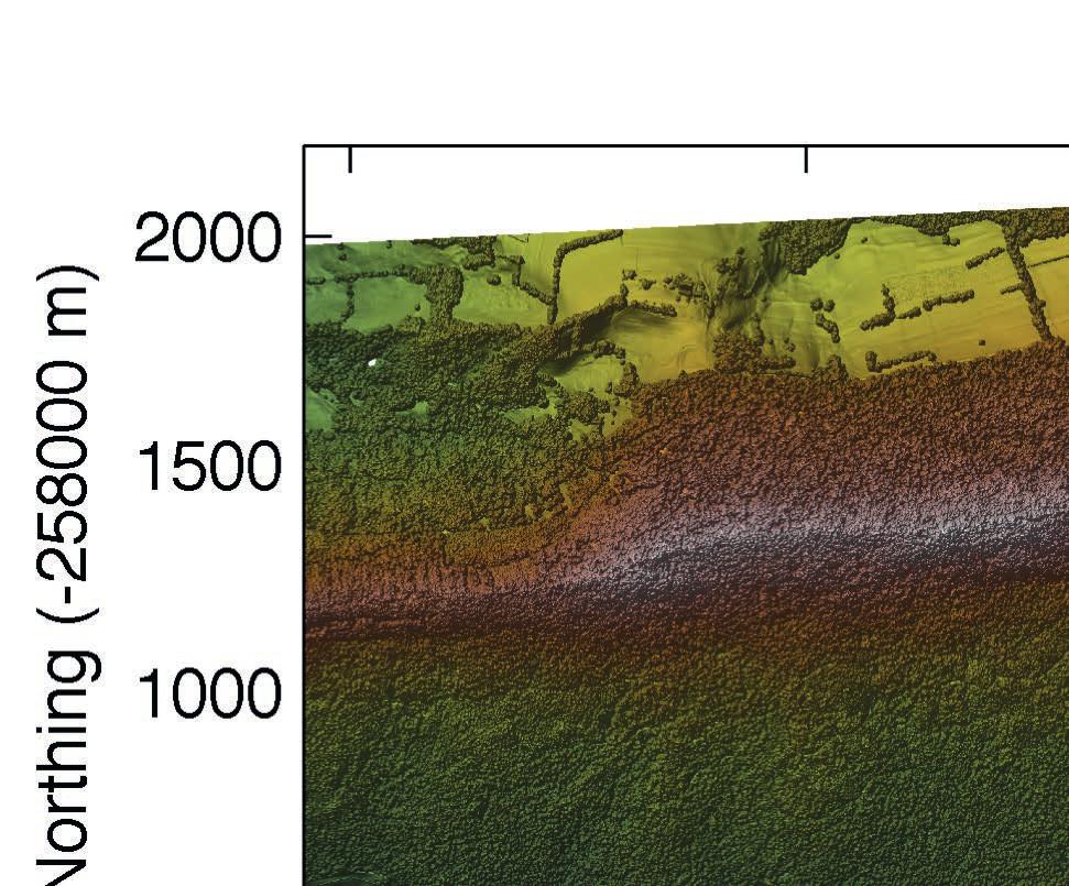
Digitale Reliefanalyse
 Digitale Reliefanalyse Modul 211 Arbeitsverzeichnisse Ihre Arbeitsverzeichnisse finden Sie unter: home_stud/modul_211/kursx Legen Sie in Ihrem Arbeitsverzeichnis ein Unterverzeichnis mit Namen: Hoehen
Shock pulse measurement principle
 Shock pulse measurement principle a [m/s²] 4.0 3.5 3.0 Roller bearing signals in 36 khz range Natural sensor frequency = 36 khz 2.5 2.0 1.5 1.0 0.5 0.0-0.5-1.0-1.5-2.0-2.5-3.0-3.5-4.0 350 360 370 380 390
GridMate The Grid Matlab Extension
 GridMate The Grid Matlab Extension Forschungszentrum Karlsruhe, Institute for Data Processing and Electronics T. Jejkal, R. Stotzka, M. Sutter, H. Gemmeke 1 What is the Motivation? Graphical development
Internationale Energiewirtschaftstagung TU Wien 2015
 Internationale Energiewirtschaftstagung TU Wien 2015 Techno-economic study of measures to increase the flexibility of decentralized cogeneration plants on a German chemical company Luis Plascencia, Dr.
Some Theory on magnetic susceptibility logging
 Some Theory on magnetic susceptibility logging Based on the publication: Nowaczyk, N.R. (2001): Logging of magnetic susceptibility, in: Tracking Environmental Changes in Lake Sediments: Basin Analysis,
Free space optic system for hop lengths up to 2000 m; Alarms can be transmitted to a maximum of four email addresses;
 CBL Communication by light Gesellschaft für optische Kommunikationssysteme mbh No longer failures due to weather conditions! AirLaser Free space optic system for hop lengths up to 2000 m; Designed for
Aktuelle und kommende Fernerkundungsdaten und ihr Nutzungspotential. E F T A S Fernerkundung Technologietransfer GmbH
 Aktuelle und kommende Fernerkundungsdaten und ihr Nutzungspotential E F T A S Fernerkundung Technologietransfer GmbH Oliver Buck Halle (Saale), 18.02. www.eftas.com 1 Den Überblick behalten EFTAS GmbH
Bayerisches Landesamt für Gesundheit und Lebensmittelsicherheit Pool water quality the German philosophy
 Bayerisches Landesamt für Gesundheit und Lebensmittelsicherheit Pool water quality the German philosophy Christiane Höller Bavarian Health and Food Safety Authority Legal regulations 1979 Federal Law on
5 mm (T1 3 / 4 ) MULTILED, Diffused LU 5351
 MULTILED, Diffused LU 5351") 5 mm (T1 3 / 4 ) MULTILED, Diffused LU 5351 Besondere Merkmale nicht eingefärbtes, teilweise diffuses Gehäuse Lötspieße im 2.54 mm Raster hohe Signalwirkung durch Farbwechsel der LED möglich Anzeige unterschiedlicher
5 mm (T1 3 / 4 ) MULTILED, Diffused LU 5351 Besondere Merkmale nicht eingefärbtes, teilweise diffuses Gehäuse Lötspieße im 2.54 mm Raster hohe Signalwirkung durch Farbwechsel der LED möglich Anzeige unterschiedlicher
There are 10 weeks this summer vacation the weeks beginning: June 23, June 30, July 7, July 14, July 21, Jul 28, Aug 4, Aug 11, Aug 18, Aug 25
 Name: AP Deutsch Sommerpaket 2014 The AP German exam is designed to test your language proficiency your ability to use the German language to speak, listen, read and write. All the grammar concepts and
Context-adaptation based on Ontologies and Spreading Activation
 -1- Context-adaptation based on Ontologies and Spreading Activation ABIS 2007, Halle, 24.09.07 {hussein,westheide,ziegler}@interactivesystems.info -2- Context Adaptation in Spreadr Pubs near my location
Minimierung des Fündigkeitsrisikos mit Hilfe von 2D- und 3D-Seismik
 Minimierung des Fündigkeitsrisikos mit Hilfe von 2D- und 3D-Seismik René Graf MD Subsurface Exploration Integrated Approach Acquisition Existing Studies Processing Wells, Outcrops Seismic Interpretation
3 Fernerkundungsdaten
 Fernerkundungsdaten 31 3 Fernerkundungsdaten Im Rahmen der Arbeit konnten sowohl Daten der Satellitenebene als auch flugzeuggetragenen hyperspektrale Sensoren untersucht werden. Eine Übersicht über grundlegende
TomTom WEBFLEET Tachograph
 TomTom WEBFLEET Tachograph Installation TG, 17.06.2013 Terms & Conditions Customers can sign-up for WEBFLEET Tachograph Management using the additional services form. Remote download Price: NAT: 9,90.-/EU:
DATA ANALYSIS AND REPRESENTATION FOR SOFTWARE SYSTEMS
 DATA ANALYSIS AND REPRESENTATION FOR SOFTWARE SYSTEMS Master Seminar Empirical Software Engineering Anuradha Ganapathi Rathnachalam Institut für Informatik Software & Systems Engineering Agenda Introduction
TMF projects on IT infrastructure for clinical research
 Welcome! TMF projects on IT infrastructure for clinical research R. Speer Telematikplattform für Medizinische Forschungsnetze (TMF) e.v. Berlin Telematikplattform für Medizinische Forschungsnetze (TMF)
ISO 15504 Reference Model
 Process flow Remarks Role Documents, data, tools input, output Start Define purpose and scope Define process overview Define process details Define roles no Define metrics Pre-review Review yes Release
Exercise (Part XI) Anastasia Mochalova, Lehrstuhl für ABWL und Wirtschaftsinformatik, Kath. Universität Eichstätt-Ingolstadt 1
 Anastasia Mochalova, Lehrstuhl für ABWL und Wirtschaftsinformatik, Kath. Universität Eichstätt-Ingolstadt 1") Exercise (Part XI) Notes: The exercise is based on Microsoft Dynamics CRM Online. For all screenshots: Copyright Microsoft Corporation. The sign ## is you personal number to be used in all exercises. All
Exercise (Part XI) Notes: The exercise is based on Microsoft Dynamics CRM Online. For all screenshots: Copyright Microsoft Corporation. The sign ## is you personal number to be used in all exercises. All
Quadt Kunststoffapparatebau GmbH
 Quadt Kunststoffapparatebau GmbH Industriestraße 4-6 D-53842 Troisdorf/Germany Tel.: +49(0)2241-95125-0 Fax.: +49(0)2241-95125-17 email: info@quadt-kunststoff.de Web: www.quadt-kunststoff.de Page 1 1.
Was ist das? Wer an einem sonnigen Tag die runden Lichtflecken unter einem Baum einmal entdeckt hat, findet sie immer und überall wieder.
 Was ist das? Wer an einem sonnigen Tag die runden Lichtflecken unter einem Baum einmal entdeckt hat, findet sie immer und überall wieder. Was hat es mit dem Phänomen auf sich? Der Light Walk verführt zum
SARA 1. Project Meeting
 SARA 1. Project Meeting Energy Concepts, BMS and Monitoring Integration of Simulation Assisted Control Systems for Innovative Energy Devices Prof. Dr. Ursula Eicker Dr. Jürgen Schumacher Dirk Pietruschka,
Innovation in der Mikrobearbeitung
 Presseinformation August 2011 / 1. von 3 Seiten Werbung und PR Telefon (0 61 72) 1 06-461 Telefax (0 61 72) 1 06-213 E-Mail s.dillmann@wexo.com Innovation in der Mikrobearbeitung Neuer Mikrobohrer aus
USBASIC SAFETY IN NUMBERS
 USBASIC SAFETY IN NUMBERS #1.Current Normalisation Ropes Courses and Ropes Course Elements can conform to one or more of the following European Norms: -EN 362 Carabiner Norm -EN 795B Connector Norm -EN
POR. Präzisions-O-Ring Precision O-Ring
 POR Die Hunger e und Rundschnurringe werden für statische Abdichtungen eingesetzt. Durch eine große Auswahl geeigneter Dichtungswerkstoffe werden Dichtungsprobleme bei verschiedenen Druckmedien, Drücken
Ausarbeitung Iteration I
 Ausarbeitung Iteration I Domain Model siehe [Lar02], Kap. 0 2 Domain Model Illustriert relevante Konzepte des Problembereichs Das wichtigste Dokument in OOA (Use-Cases sind nicht OO; Use-Cases sind ein
DOWNLOAD. Me and my body. Erste Schritte in Englisch. Anne Scheller. Downloadauszug aus dem Originaltitel: Klasse 3 4
 DOWNLOAD Anne Scheller Me and my body Erste Schritte in Englisch Klasse 3 4 auszug aus dem Originaltitel: Mit Geschichten, vielfältigen Übungen und Materialien zur Portfolio-Arbeit THE TERRIBLE TOM Luke
Westenberg Wind Tunnels
 MiniAir20 Hand measurement device for flow, humidity and temperature The hand measurement device MiniAir20 is used for the acquisition of temperature, relative humidity, revolution and flow velocity such
Statistics, Data Analysis, and Simulation SS 2015
 Mainz, June 11, 2015 Statistics, Data Analysis, and Simulation SS 2015 08.128.730 Statistik, Datenanalyse und Simulation Dr. Michael O. Distler Dr. Michael O. Distler
ø GEO GEX Maße in mm, wenn nicht anders angegeben/dimensions in mm, unless otherwise specified.
 GaAs-IR-Lumineszenzdioden GaAs Infrared Emitters 415 Cathode spacing 2.54mm 2.54 mm spacing 1.8 1.2 29 27 Area not flat Chip position.8 Approx. weight.2 g Area not flat.8 1.8 1.2 29.5 27.5 Cathode (Diode)
Cloud Architektur Workshop
 Cloud Architektur Workshop Ein Angebot von IBM Software Services for Cloud & Smarter Infrastructure Agenda 1. Überblick Cloud Architektur Workshop 2. In 12 Schritten bis zur Cloud 3. Workshop Vorgehensmodell
Group and Session Management for Collaborative Applications
 Diss. ETH No. 12075 Group and Session Management for Collaborative Applications A dissertation submitted to the SWISS FEDERAL INSTITUTE OF TECHNOLOGY ZÜRICH for the degree of Doctor of Technical Seiences
Contents. Interaction Flow / Process Flow. Structure Maps. Reference Zone. Wireframes / Mock-Up
 Contents 5d 5e 5f 5g Interaction Flow / Process Flow Structure Maps Reference Zone Wireframes / Mock-Up 5d Interaction Flow (Frontend, sichtbar) / Process Flow (Backend, nicht sichtbar) Flow Chart: A Flowchart
MULTI PHYSICS SIMULATION IN MANUFACTURING
 MULTI PHYSICS SIMULATION IN MANUFACTURING A. Junk CADFEM GmbH Contents Manufacturing Multi Physics in Manufacturing Manufacturing example: Residual Stresses in an Induction Hardened Roll Set up Conclusions
Workshop Aktuelle Entwicklungen bei der Auswertung von Fernerkundungsdaten für forstliche Aufgabenstellungen
 Workshop Aktuelle Entwicklungen bei der Auswertung von Fernerkundungsdaten für forstliche Aufgabenstellungen Schätzung von Holzvorräten und Baumartenanteilen mittels Wahrscheinlichkeitsmodellen Haruth
p^db=`oj===pìééçêíáåñçêã~íáçå=
 p^db=`oj===pìééçêíáåñçêã~íáçå= How to Disable User Account Control (UAC) in Windows Vista You are attempting to install or uninstall ACT! when Windows does not allow you access to needed files or folders.
POLDIRAD Measurements
 POLDIRAD Measurements Martin Hagen and Hartmut Höller Jens Reimann, Lothar Oswald, Hermann Scheffold, DLR Oberpfaffenhofen Polarization Doppler Radar POLDIRAD 1986 installed as the first fully polarimetric
PROLED STRIPS FLEX STRIP 300 MONO
 2013 FLEX STRIP 300 MONO dimmbar oder per DMX 512, DALI, 1-10 V ansteuerbar über MBNLED RGB MULTI Netzteile/Controller Spannungsversorgung: 12 VDC 2x Kabel 2-POL auf offenes Kabelende Breite x Höhe: 8
Support Technologies based on Bi-Modal Network Analysis. H. Ulrich Hoppe. Virtuelles Arbeiten und Lernen in projektartigen Netzwerken
 Support Technologies based on Bi-Modal Network Analysis H. Agenda 1. Network analysis short introduction 2. Supporting the development of virtual organizations 3. Supporting the development of compentences
Aufnahmeuntersuchung für Koi
 Aufnahmeuntersuchung für Koi Datum des Untersuchs: Date of examination: 1. Angaben zur Praxis / Tierarzt Vet details Name des Tierarztes Name of Vet Name der Praxis Name of practice Adresse Address Beruf
Beobachtung der Biosphärendynamik II
 Dynamik der Biosphäre Beobachtung der Biosphärendynamik II Wintersemester 2008/2009 Wolfgang Cramer Lehrstuhl "Globale Ökologie" http://www.pik-potsdam.de/~cramer -> "Teaching" Letzte Woche Die exogene
p^db=`oj===pìééçêíáåñçêã~íáçå=
 p^db=`oj===pìééçêíáåñçêã~íáçå= Error: "Could not connect to the SQL Server Instance" or "Failed to open a connection to the database." When you attempt to launch ACT! by Sage or ACT by Sage Premium for
MHG - Modular Humidity Generator
 MHG - Modular Humidity Generator Humidity Control Kontrollierte Luftfeuchtigkeit To provide reliable and reproducible results, an increasing number of analytical test methods require controlled environmental
Eingebettete Taktübertragung auf Speicherbussen
 Eingebettete Taktübertragung auf Speicherbussen Johannes Reichart Workshop Hochgeschwindigkeitsschnittstellen Stuttgart, 07.11.2008 Unterstützt durch: Qimonda AG, München Institut für Prof. Elektrische
Prof. Dr. Bryan T. Adey
 Leiter der Bachelor- Prof. Dr. Bryan T. Adey Institut: Fachbereich: IBI Infrastrukturmanagement Anzahl Themen: 5 Themen direkt auf der Website der Professur/des Instituts veröffentlicht Link: http://www.im.ibi.ethz.ch/lehre/studienarbeit
a new line of steam sterilizers
 a new line of steam sterilizers ticheeasy to use and high consumption savings multifunction display controlled by micro-processor double and patented motor-operated closure stainless steel chamber without
Level 1 German, 2012
 90886 908860 1SUPERVISOR S Level 1 German, 2012 90886 Demonstrate understanding of a variety of German texts on areas of most immediate relevance 9.30 am Tuesday 13 November 2012 Credits: Five Achievement
2. Physikalische Grundlagen
 Fernerkundung Lernmodul 6 Projektpartner: UniversitÄt Karlsruhe - Institut für Photogrammetrie und Fernerkundung Datum: 04.09.2003 Einleitung In der Fernerkundung werden Informationen Über Objekte durch
GMES-Echtzeitdienste: Anforderungen an die Bodenempfangsstation und das Datenmanagement
 GMES-Echtzeitdienste: Anforderungen an die Bodenempfangsstation und das Datenmanagement H. Maass, E. Schwarz, S. Lehner* Nationales Bodensegment Deutsches Fernerkundungsdatenzentrum (DFD) * Institut für
TerraSAR and German Contributions to the GMES Programme
 TerraSAR and German Contributions to the GMES Programme Gunter Schreier Business Development and GMES Coordination DLR German Remote Sensing Data Center The German Aerospace Center (DLR) Largest R&D institution
NEWSLETTER. FileDirector Version 2.5 Novelties. Filing system designer. Filing system in WinClient
 Filing system designer FileDirector Version 2.5 Novelties FileDirector offers an easy way to design the filing system in WinClient. The filing system provides an Explorer-like structure in WinClient. The
Modelling CO 2 and trace gas exchange between landsurface
 Modelling CO 2 and trace gas exchange between landsurface and atmosphere Rüdiger Grote (Ruediger.Grote@kit.edu) Institut für Meteorologie und Klimaforschung, Atmosphärische Umweltforschung, Garmisch-Partenkirchen,
Titelbild1 ANSYS. Customer Portal LogIn
 Titelbild1 ANSYS Customer Portal LogIn 1 Neuanmeldung Neuanmeldung: Bitte Not yet a member anklicken Adressen-Check Adressdaten eintragen Customer No. ist hier bereits erforderlich HERE - Button Hier nochmal
Technische Universität Berlin
 Technische Universität Berlin Fachbereich Wirtschaft und Management Institut für Technologie und Management Lehrstuhl für Innovations- und Technologiemanagement Prof. Dr. Hans Georg Gemünden TU Berlin.
JONATHAN JONA WISLER WHD.global
 JONATHAN WISLER JONATHAN WISLER WHD.global CLOUD IS THE FUTURE By 2014, the personal cloud will replace the personal computer at the center of users' digital lives Gartner CLOUD TYPES SaaS IaaS PaaS
Application of Sensor Networks
 1/29 Application of Sensor Networks Institute of Telematics Universität Karlsruhe GI-Dagstuhl-Forschungsseminar Nr. 05473, Algorithmen für Sensor- und Ad-hoc-Netzwerke, 23.-25. November 2005, IBFI Schloss
Inequality Utilitarian and Capabilities Perspectives (and what they may imply for public health)
") Inequality Utilitarian and Capabilities Perspectives (and what they may imply for public health) 1 Utilitarian Perspectives on Inequality 2 Inequalities matter most in terms of their impact onthelivesthatpeopleseektoliveandthethings,
Inequality Utilitarian and Capabilities Perspectives (and what they may imply for public health) 1 Utilitarian Perspectives on Inequality 2 Inequalities matter most in terms of their impact onthelivesthatpeopleseektoliveandthethings,