Validation of Coastal Wind and Wave Fields by High Resolution Satellite Data
|
|
|
- Alma Fischer
- vor 6 Jahren
- Abrufe
Transkript

1 Validation of Coastal Wind and Wave Fields by High Resolution Satellite Data Susanne Lehner, Miguel Bruck, Andrey Pleskachevsky German Aerospace Center
2 SWH by CWAVE from Global ENVISAT ASAR Data J. Schulz-Stellenfleth et al., JGR, X. Li et al., IEEE Folie 2 2


3 Spatial variability of sea state (~300m) by TerraSAR-X images 5km Pico island, Azores TerraSAR-X Stripmap VV pol. February 9, :41 Folie 3 Institut für Methodik der Fernerkundung bzw. Earth Deutsches Fernerkundungsdatenzentrum Observation Center 3
4 Spatial variability of sea state (~300m) by TerraSAR-X images XWAVE algorithm Hs=3.4 Lp=326m T=14.7s Hs=3.5 Lp=300m T=13.9s Hs=3.6m Lp=310m T=14.1s Hs=2.4m Lp=320m T=14.3s Pico island, Azores TerraSAR-X Stripmap VV pol. February 9, :41 Folie 4 Institut für Methodik der Fernerkundung bzw. Earth Deutsches Fernerkundungsdatenzentrum Observation Center 4

5 Horizon mask Neustrelitz for TerraSAR-X and ENVISAT Near Real Time Services for TS-X in < 20 min in European MarSur Projects MARISS with EMSA, JRC, ESA, several European satellite providers Folie 5 5
 Connection between Radar")
, Interpolation SAR Image")

6 Wind Field: XMOD Algorithm Geophysical Model Function GMF (Wind Roughness of Sea Surface) Connection between Radar NRCS, Wind Speed, Wind Direction and Incidence Angle SAR Image Streaks (2D-FFT, ), Interpolation SAR Image Calibration Wind Direction NRCS Inversion XMOD Wind Einfallswinkel Wind Incidence Flight Direction waves Angle Wind-Flight Folie 6 6
7 Development of the X-band GMF for sea surface wind field retrieval XMOD1, linear inversion 0 ( U10,, ) x0 x1u 10 x2 sin( ) x3 cos( 2 ) x4u 10 cos( 2 ) XMOD2, non-linear inversion, comparable to CMOD GMF U U,, ( A ( U,, ) cos n 0 10 n 10 ) 10 2 n 0 wind speed; incidence angle; angle between wind direction and SAR look direction XMOD1, Y. Ren et al, IJRS, tuning dataset from X-SAR (shuttle mission) XMOD2, X. Li et al, Spie 2011 (tuning onts-x data) Folie 7 7

8 Comaprison of Wind Speed Algorithms Folie 8 8


9 Case study over Alpha Ventus Alpha Ventus is the first offshore wind farm of Germany, located at the North Sea 58 m 90 m 5MW Wind turbine Folie 9 9

10 Case study over Alpha Ventus, Wind Farm North Sea TS-X Stripmap Aug.7, 2011 at 17:18 UTC VV polarization, spatial res. 3 m Folie 10 10


11 Sea surface wind field derieved from the TS-X data over Alpha Ventus XMOD2 XMOD1 Folie 11 11


12 Comparison of TS-X wind measurements to DWD (global) model 18:00UTC Higher variability in TS-X data Folie 12 12


13 Wind Input K-Model wind+3m/s wind wind - 3m/s JONSWAP Area GKSS (HZG) buoy Lehner, IJRS, 2011 Hs GKSS- modelled wave by K-model rider buoy measurement Folie 13 13
 mean m mean S FFT (m) signal modulation m")
 dkd filtering,")

14 XWAVE: Sea State Parameters from TerraSAR-X Images sub-scene signal intensity I I I( i, j) mean m mean S FFT (m) signal modulation m image spectra S TerraSAR-X SM Elbe estuary sub scene 2-D Imagespektrum im Wellenzahlraum E k min k max S( k, ) dkd filtering, L min, L max XWAVE function Parameters: H s, L p,t p 1D Spektrum im Frequenzraum buoy spectrum integrated image spectrum 100 m 50 m 2D image spectrum Folie 14 14
15 H s a * a E(1.0 a2 cos ) 3 Statitistics Wave Length XWAVE Empirical Algorithm Collecting data set over NOAA buoys, Image data have to be ordered for acquisition about 2 days in advance Folie 15 15
16 XWAVE Algorithm: estimation of Significant wave height from TS-X data Hs based on analysis of image spectra and uses fitted parameters a 1 E sin (1.0 a 2 cos( )) 4 a 3 flight θ E - total energy calculted from the image spectrum in domain λ min and λ max. θ - the incidence angle α - peak wave direction relative to azimuth (satellite flight) direction a 1..a 3 - coefficients determined by TS-X,TD-X data fitting with wave height given by buoys and DWD (German weather center) wave model data. waves α Folie 16 16

17 Modelling of Sea State over Helgoland with K Model and boundary conditions from TS-X North Sea, Helgoland Lehner et al. IJRS, 2011 Topography BSH Folie 17 17
 - wind sea (JONSWAP spectra) Boundaty spectra from TSX XWIND, XWAVE Folie 18")
18 SWH from K-Model with boundary conditions from TS-X The wind field: XMOD boundary spectra include two parts: - swell (obtained using XWAVE) - wind sea (JONSWAP spectra) Boundaty spectra from TSX XWIND, XWAVE Folie 18 18


19 Application: Sea-State spatial Variability and Wind Field estimation using TerraSAR-X Synthetic Aperture Radar Data buoy sea state at wave power plant differs from the one at the buoy location Comparison of spectral shape parameters for image and wave spectra buoy collocated measurement s Independent measurements - Spatial variability is observed by TS-X imagery - Wind field estimated Folie 19 19

 Tp (s) T 02 (s) T -10 (s)")
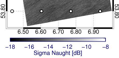
20 Example: Pico island, Sea State near Pico Wave Farm S(m2/Hz) Buoy spectrum SAR spectrum 10 2d spectrum frequency(hz) 1d frequency spectrum SM, VV polarization, February 14, 2011 M.Bruck et al, EWTEC, Buoy 19:30 TS-X 19:41 H s (m) Tp (s) T 02 (s) T -10 (s) m ( ) Folie 20 20


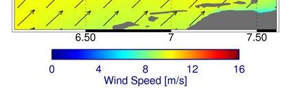
21 Pico island: TD-X Stripmap VV polarization. February 14, :49, ASCAT time: 22:00 Wind vectors derived by the ASCAT Wind speed derived from TS-X data Folie 21 21


22 Determination of Underwater Bathymetry using Dispersion Relation Rottenest Island A. Pleskachevsky et al., Ocean Dynamics Folie 22 Institut für Methodik der Fernerkundung bzw. Earth Deutsches Fernerkundungsdatenzentrum Observation Center 22

23 Underwatertopograpy from TerraSAR SAR and Optical Grid size 150m Folie 23 23


24 Determination of Underwater Bathymetry Validation A.Plekachevky et al Oceandynamics, 2011 Folie 24 24
25 Summary Obtained information on the highly variable wind field and sea state in coastal areas using high resolution TerraSAR data Use information from refraction to obtain underwater bathymetry Methods Estimation by XMOD and XWAVE algorithm Comparison/Validation of wind field sea state parameters derived from TS-X SAR data with in-situ buoy measurements. Characterization of sea sate using integrated sea state and spectral shape parameters Goal Real Time Satellite Services for North Sea, Baltic Sea, Mediterranean in cooperation with DWD NRT Maritime Monitoring Services in European Framework, EMSA, JRC, Folie 25 FRONTEX 25


26 Thank you for your attention! Folie 26 26


27 ENVISAT Wind Sea State Oil Land-Water Line Bathymetry Sea Ice Folie 27 27


![..10 km [Range Azimuth] Harbour, breakwaters, platforms](/docs-images/77/75913074/images/28-5.jpg "ScanSAR Mode Resolution: 16 m 16 m Scene Size: 100 km 150")
28 TerraSAR-X Nominal Imaging Modes StripMap Mode Resolution: 3 m 3 m Scene Size: 30 km 50 km [Range Azimuth] Coastal NRT < 20 min SpotLight Mode Resolution: 1 m 1,5... 3,5 m Scene Size: 10 km km [Range Azimuth] Harbour, breakwaters, platforms ScanSAR Mode Resolution: 16 m 16 m Scene Size: 100 km 150 km [Range Azimuth] Ships, sea ice Folie 28 28


29 Pico island: Spotlight VV polarization, 27 March :41 λ p p m λ p p 244 m 330 Boxsize: 770 m Folie 29 29

30 Wind Field Algorithm XMOD 1.0 Incident angle [ ] Wind direction [ ] NRCS by XMOD dependent on Incidence angle and wind direction (at angle of 35 ). Y. Ren et al IJRS, PORSEC 2010 Folie 30 30


31 Implementierung aus SAR abgeleiteter Parameter in numerische Seegangsmodelle TerraSAR-X Szene Wind und Randwerte Topographie und Seegangsmodell Seegangsmodel Ergebnisse Randspektrum aus zwei Teilen: - Dünung (XWAVE) - Windsee (JONSWAP) Windfeld: XMOD Algorithmus Seegang: XWAVE Algorithmus Folie 31 31


")

32 Graciosa island: Stripmap VV polarization February 13, Buoy spectrum SAR spectrum S(m2/hz) D spectrum frequency(hz) 1 D spectrum Buoy 8:39 TSX 7:55 H s (m) T p (s) T 02 (s) T -10 (s) m ( ) Folie 32 32
Remote Sensing Products for Environmental Assessment at Offshore Platforms and Pipelines
 Remote Sensing Products for Environmental Assessment at Offshore Platforms and Pipelines Susanne Lehner, Thomas König Domenico Velotto, Stephan Brusch German Aerospace Center (DLR) Remote Sensing Technology
Extraction of Wind and Wave Field from SAR data
 Extraction of Wind and Wave Field from SAR data S. Lehner, X. Li, Th. Bruns, W. Rosenthal German Aerospace Center (DLR), Oberpfaffenhofen Motivation Derive integrated Wave Parameters (e.g. SWH, mean period)
Meteo-marine Parameter aus Radarsatellitendaten
 SAR Maritime Applications Maritime Security and Safety Lab Forschungsstelle Maritime Sicherheit DLR BF IMF OP DLR Bremen Flughafen, Institut für Methodik der Fernerkundung, Oberpfaffenhofen Susanne Lehner,
Use of ALOS-PALSAR for Oceanography
 Use of ALOS-PALSAR for Oceanography Remote Sensing Technology Institute German Aerospace Agency, DLR-Germany S.Lehner, S.Brusch, Li XiaoMing, T. König SAR Oceanography Algorithms SAR Processor Wind Field
Susanne Lehner Deutsches Zentrum für Luft- und Raumfahrt
 Gefahren auf dem Wasser Piraten, Packeis und Monsterwellen Susanne Lehner Deutsches Zentrum für Luft- und Raumfahrt Münchner Wissenschaftstage 12.-15.November Untergang der MS München im Nordatlantik Artist
Meteorological measurements at the Offshore Platform FINO 2 - new insights -
 FINO 2011 Conference May 11 th 2011, Hamburg, Germany Meteorological measurements at the Offshore Platform FINO 2 - new insights - Dipl.-Geoök. Stefan Müller, Dipl.-Ing Joachim Schwabe Content 1. FINO
Verbesserte Vorhersagen für Offshore-Industrie, Küstenschifffahrt und Küstenschutz
 Verbesserte Vorhersagen für Offshore-Industrie, Küstenschifffahrt und Küstenschutz Abschlusspräsentation TP 3 Seegangsmonitor Bonn, 02.12.2015 Jens Kieser, Peter Hoffmann, Thomas Bruns, Frank Janssen,
SAR-Ozeanographie Messung mariner Parameter Susanne Lehner. Institut für Methodik der Fernerkundung
 SAR-Ozeanographie Messung mariner Parameter Susanne Lehner der Algorithmenentwicklung Eine Million ERS Wave Mode SAR Bilder prozessiert Windfelder
Near Real Time - SAR basierte Anwendungen im maritimen Bereich
 GeoForum MV 2011 Near Real Time - SAR basierte Anwendungen im maritimen Bereich Matthias Berg, Susanne Lehner, Stephan Brusch, Egbert Schwarz DLR Cluster Angewandte Fernerkundung Inhalt Übersicht Synthetic
NEREUS Workshop Maritime Security
 SAR Maritime Applications Maritime Security and Safety Lab Forschungsstelle Maritime Sicherheit DLR BF IMF OP DLR Bremen Flughafen, Institut für Methodik der Fernerkundung, Oberpfaffenhofen NEREUS Workshop
Regionale Reanalysen
 Regionale Reanalysen Frank Kaspar mit Beiträgen von Andrea Kaiser-Weiss, Michael Borsche (DWD) sowie dem Hans-Ertel-Zentrum für Wetterforschung Teilbereich Klimamonitoring, Universität Bonn the Climate
TP 3 Seegangsmonitor. Dr. Jens Kieser, Dr. Thomas Bruns. DeMarine-2 Gesamtprojekttreffen, 15. Mai Assoziierte Partner.
 TP 3 Seegangsmonitor Dr. Jens Kieser, Dr. Thomas Bruns Assoziierte Partner 1 Anforderungen im Offshore-Bereich Zunehmender Schiffsverkehr durch den Ausbau der Offshore-Industrie Verschleppung von Plattformen
Remote Sensing Technology Institute, DLR Germany. Synergetic use of Radar and optical Satellite Images to Support Severe Storm Prediction
 Remote Sensing Technology Institute, DLR Germany Synergetic use of Radar and optical Satellite Images to Support Severe Storm Prediction S. Brusch, S. Lehner, J.-S. Stellenfleth SEASAR 2008, Frascati-Rome-Italy
Using TerraSAR-X data for mapping of damages in forests caused by the pine sawfly (Dprion pini) Dr. Klaus MARTIN klaus.martin@slu-web.
 Dr. Klaus MARTIN klaus.martin@slu-web.") Using TerraSAR-X data for mapping of damages in forests caused by the pine sawfly (Dprion pini) Dr. Klaus MARTIN klaus.martin@slu-web.de Damages caused by Diprion pini Endangered Pine Regions in Germany
Using TerraSAR-X data for mapping of damages in forests caused by the pine sawfly (Dprion pini) Dr. Klaus MARTIN klaus.martin@slu-web.de Damages caused by Diprion pini Endangered Pine Regions in Germany
Aktuelle Anwendung von Fernerkundungsdaten
 Literaturhinweis: ALBERTZ, Jörg (2007): Einführung in die Fernerkundung, Grundlagen der Interpretation von Luft- und Satellitenbildern, 3. Auflage, Wisssenschaftliche Buchgemeinschaft Darmstadt Grundlagen
GMES-Echtzeitdienste: Anforderungen an die Bodenempfangsstation und das Datenmanagement
 GMES-Echtzeitdienste: Anforderungen an die Bodenempfangsstation und das Datenmanagement H. Maass, E. Schwarz, S. Lehner* Nationales Bodensegment Deutsches Fernerkundungsdatenzentrum (DFD) * Institut für
Nationalen Forum für Fernerkundung und Copernicus 2017
 Nationalen Forum für Fernerkundung und Copernicus 2017 Zugang zu Copernicus Daten und Produkten in Nahe Echtzeit Egbert Schwarz Deutsches Zentrum für Luft und Raumfahrt (DLR) Deutsches Fernerkundungsdatenzentrum
Geostatistics for modeling of soil spatial variability in Adapazari, Turkey
 1 Geostatistics for modeling of soil spatial variability in Adapazari, Turkey Jack W. Baker Michael H. Faber (IBK) ETH - Zürich 2 Practical evaluation of liquefaction occurrence Obtained from empirical
in Dano, Burkina Faso
 Energy Balance Measurements and Radiosoundings in Dano, Burkina Faso Martin Kohler, Norbert Kalthoff, Stephanie Heidt Forschungszentrum Karlsruhe (FZK) Institute for Meteorology and Climate Research (IMK-TRO)
A parameterised 3D-Structure-Model for the state of Bremen (Germany)
") A parameterised 3D-Structure-Model for the state of Bremen (Germany) An application for detailled groundwater flow and transport studies Bremen Geography and Geology 3 Bremen Geography and Geology 4 Structual
A parameterised 3D-Structure-Model for the state of Bremen (Germany) An application for detailled groundwater flow and transport studies Bremen Geography and Geology 3 Bremen Geography and Geology 4 Structual
GAUSS towards a common certification process for GNSS applications using the European Satellite System Galileo
 GAUSS towards a common certification process for GNSS applications using the European Satellite System Galileo Matthias Grimm, Dr. Michael Meyer zu Hörste Vortragstitel > 11. Juni 2010 > Folie 1 Agenda
Determination of tornado intensity from forest damage
 Determination of tornado intensity from forest damage Veronika Beck 1,2, Nikolai Dotzek 2, Robert Sausen 2 1 Physik-Department,, Garching, Germany 2 DLR-Institut für Physik der Atmosphäre, Oberpfaffenhofen,
Fishing effort in the Wadden Sea Difficult estimates in dendritic landscapes
 Fishing effort in the Wadden Sea Difficult estimates in dendritic landscapes Dr. Torsten Schulze, Katharina Schulte Thünen Institut für Seefischerei, Hamburg Hamburg, Dr. Torsten Schulze, Katharina Schulte
Air-Sea Gas Transfer: Schmidt Number Dependency and Intermittency
 Air-Sea Gas Transfer: Schmidt Number Dependency and Intermittency Bernd Jähne, Reinhard Nielsen, Christopher Pop, Uwe Schimpf, and Christoph Garbe Interdisziplinäres Zentrum für Wissenschaftliches Rechnen
POLDIRAD Measurements
 POLDIRAD Measurements Martin Hagen and Hartmut Höller Jens Reimann, Lothar Oswald, Hermann Scheffold, DLR Oberpfaffenhofen Polarization Doppler Radar POLDIRAD 1986 installed as the first fully polarimetric
J. Schulz-St., R. Weisse, B. Geyer, B. Rockel, E. Stanev, C. Schrum. Institut für Küstenforschung Geesthacht, Max-Planck-Str.
 Offshore-Windenergie: Modellbasierte Untersuchungen zu Umweltauswirkungen und Bereitstellung von Informationsprodukten für Planungs-, Bau-, und Betriebsphase J. Schulz-St., R. Weisse, B. Geyer, B. Rockel,
FEM Isoparametric Concept
 FEM Isoparametric Concept home/lehre/vl-mhs--e/cover_sheet.tex. p./26 Table of contents. Interpolation Functions for the Finite Elements 2. Finite Element Types 3. Geometry 4. Interpolation Approach Function
Climate change and availability of water resources for Lima
 Climate change and availability of water resources for Lima András Bárdossy bardossy@iws.uni-stuttgart.de Lima Marzo 12. 2009 1 Engineers and the future Knowledge about Past Design for Future Lima Marzo
Technische Universität Kaiserslautern Lehrstuhl für Virtuelle Produktentwicklung
 functions in SysML 2.0 La Jolla, 22.05.2014 12/10/2015 Technische Universität Kaiserslautern Lehrstuhl für Virtuelle Produktentwicklung Dipl. Wirtsch.-Ing. Christian Muggeo Dipl. Wirtsch.-Ing. Michael
Pilot Project Biogas-powered Micro-gas-turbine
 1/18 Pilot Project Biogas-powered Micro-gas-turbine Supported by the Hessischen Ministerium für Wirtschaft, Verkehr und Landesentwicklung Speaker Details 2/18 Jan Müller Works at Institute of Solar Energy
Numerical Analysis of a Radiant Syngas Cooler
 Numerical Analysis of a Radiant Syngas Cooler Folie 2, Dr.-Ing. Gerd Oeljeklaus, Universität Duisburg-Essen Universität Duisburg-Essen Prof. Dr.-Ing., Universität Duisburg-Essen - Ulrich Günther Siemens
Applying Pléiades in the ASAP project HighSens
 Applying Pléiades in the ASAP project HighSens Highly versatile, new satellite Sensor applications for the Austrian market and International Development (Contract number: 833435) Dr. Eva Haas, GeoVille
Summary Details for Performance, Duration and Acoustic Measurements for the. Aircon 10S Wind Turbine. UK MCS Certification Summary
 Summary Details for Performance, Duration and Acoustic Measurements for the Aircon 10S Wind Turbine UK MCS Certification Summary Certificate Number MCS TUV0007 Small Wind Turbine Certification Summary
Nationalen Forum für Fernerkundung und Copernicus 2017
 Nationalen Forum für Fernerkundung und Copernicus 2017 Zugang zu Copernicus Daten und Produkten Egbert Schwarz Deutsches Zentrum für Luft und Raumfahrt (DLR) Deutsches Fernerkundungsdatenzentrum (DFD)
DEMMIN. Durable Environmental Multidisciplinary Monitoring Information Network
 DEMMIN Durable Environmental Multidisciplinary Monitoring Information Network German Aerospace Center (DLR) German Remote Sensing Data Center (DFD) Department of Ground Segment (BN) Folie 1 Neustrelitz
Numerical analysis of the influence of turbulence on the exchange processes between porous-medium and free flow
 Numerical analysis of the influence of turbulence on the exchange processes between porous-medium and free flow T. Fetzer Institut für Wasser- und Umweltsystemmodellierung Universität Stuttgart January
Content. VOR Weather radar Surveillance radar WERAN. EMC Problem and Background. Numerical Simulations in WERAN. Summary
 WERAN Improved Simulation Techniques to Analyse to the Interaction Between a Windmill Power Plant and RADAR Systems T. Schrader, J. Bredemeyer, C. Stupperich, H. Garbe Content EMC Problem and Background
EINSPEISEMANAGEMENT: GRUNDLAGEN, ANALYSE- UND PROGNOSEMÖGLICHKEITEN
 EWC WEATHER CONSULT EINSPEISEMANAGEMENT: GRUNDLAGEN, ANALYSE- UND PROGNOSEMÖGLICHKEITEN DAVID WÖLFLE 26. WINDENERGIETAGE, 08.11.2017 About Team Manager at EWC Weather Consult GmbH https://www.linkedin.com/in/david-woelfle/
ISEA RWTH Aachen Electric Bus Simulation
 ISEA RWTH Aachen Electric Bus Simulation Finding the Optimal Technical Configuration 05.04.2017 Fabian Meishner Lehrstuhl für Elektrochemische Energiewandlung und 1 Speichersystemtechnik Electric Bus Simulation
Bayesian updating in natural hazard risk assessment
 International Forum on Engineering Decision Making, Third IFED Forum, Shoal Bay, Australia, 12-15 15 December 2007 1/23 Bayesian updating in natural hazard risk assessment Mathias Graf, Kazuyoshi Nishijima,
Interpolation Functions for the Finite Elements
 Interpolation Functions for the Finite Elements For the finite elements method, the following is valid: The global function of a sought function consists of a sum of local functions: GALERKIN method: the
Requirements stemming from QPF user community
 . Werner Schulz / Dr. Manfred Bremicker, Flood Forecasting Centre Baden-Württemberg, Karlsruhe Requirements stemming from QPF user community Werner Schulz State Institut for Environmental Protection Griesbachstr.
Exploring Cryosat-2 stack data for nadir-lead detection in sea-ice regions
 Deutsches Geodätisches Forschungsinstitut (DGFI-TUM) Technische Universität München Exploring Cryosat-2 stack data for nadir-lead detection in sea-ice regions Marcello Passaro, Felix Müller, Denise Dettmering
Geodätische Messungen mit TerraSAR-X - Stand der Genauigkeit
 INTERGEO 2011 Geodätische Messungen mit TerraSAR-X - Stand der Genauigkeit Michael Eineder, N. Yague-Martinez, C. Minet, X. Cong, B. Schättler DLR Institut für Methodik der Fernerkundung Outline Goal:
Geodätische Messungen mit TerraSAR-X - Stand der Genauigkeit
 INTERGEO 2011 Geodätische Messungen mit TerraSAR-X - Stand der Genauigkeit Michael Eineder, N. Yague-Martinez, C. Minet, X. Cong, B. Schättler DLR Institut für Methodik der Fernerkundung Outline Goal:
Attention: Give your answers to problem 1 and problem 2 directly below the questions in the exam question sheet. ,and C = [ ].
![Attention: Give your answers to problem 1 and problem 2 directly below the questions in the exam question sheet. ,and C = [ ].](/thumbs/72/66904987.jpg "Attention: Give your answers to problem 1 and problem 2 directly below the questions in the exam question sheet. ,and C = [ ].") Page 1 LAST NAME FIRST NAME MATRIKEL-NO. Attention: Give your answers to problem 1 and problem 2 directly below the questions in the exam question sheet. Problem 1 (15 points) a) (1 point) A system description
Page 1 LAST NAME FIRST NAME MATRIKEL-NO. Attention: Give your answers to problem 1 and problem 2 directly below the questions in the exam question sheet. Problem 1 (15 points) a) (1 point) A system description
Introduction FEM, 1D-Example
 Introduction FEM, D-Example /home/lehre/vl-mhs-/inhalt/cover_sheet.tex. p./22 Table of contents D Example - Finite Element Method. D Setup Geometry 2. Governing equation 3. General Derivation of Finite
Data Mining and Data Analysis using the Example of cross-border Traffic Management during Extreme Weather Events
 Data Mining and Data Analysis using the Example of cross-border Traffic Management during Extreme Weather Events Dipl.-Ing. Marc Hohloch Extreme Weather Events and the Impact for Mobility of Rescue Forces
Parametric Spectral Estimation
 Parametric Spectral Estimation Exercises for Digital Signal Processing II Exercise 2.3.26 Stefan Goetze / Volker Mildner Infos about the examination Diploma students: Oral examinations on March, 29 th.-
Internationale Energiewirtschaftstagung TU Wien 2015
 Internationale Energiewirtschaftstagung TU Wien 2015 Techno-economic study of measures to increase the flexibility of decentralized cogeneration plants on a German chemical company Luis Plascencia, Dr.
Neue Datengrundlagen im Bereich Windenergie: C3S und regionale Reanalysen
 Neue Datengrundlagen im Bereich Windenergie: C3S und regionale Reanalysen Dr. Andrea Kaiser-Weiss, Referat Nationale Klimaüberwachung (KU21), Deutscher Wetterdienst (DWD) Gliederung 1) Bedarf an Daten
2011 European HyperWorks Technology Conference
 2011 European HyperWorks Technology Conference Topology Optimization Methods applied to Automotive Transmission Housings 1 Agenda Introduction - Corporate Information - overview Topology Optimization for
The German Gas Network Development Plan A contribution towards the effective implementation of the German Energiewende
 The German Gas Network Development Plan A contribution towards the effective implementation of the German Energiewende Seite 1 Agenda Schedules of the German NDPs for Gas Development of German natural
Pilot area B: Zeeland (B + NL) Pilot area C: Terschelling and Northern Fryslan (NL) Pilot area D: Borkum (D)
 Pilot area C: Terschelling and Northern Fryslan (NL) Pilot area D: Borkum (D)") Pilot area A: Belgische Middenkust, (B) Pilot area B: Zeeland (B + NL) Pilot area C: Terschelling and Northern Fryslan (NL) Pilot area D: Borkum (D) Pilot area E: Schleswig and Sdr. Jylland (D + DK) Pilot
Pilot area A: Belgische Middenkust, (B) Pilot area B: Zeeland (B + NL) Pilot area C: Terschelling and Northern Fryslan (NL) Pilot area D: Borkum (D) Pilot area E: Schleswig and Sdr. Jylland (D + DK) Pilot
Industrial USB3.0 Miniature Camera with color and monochrome sensor
 Welcome to the presentation Industrial USB3.0 Miniature Camera with color and monochrome sensor & Data rates of modern image sensors S. 1/12 Vortrag_Spectronet_USB3.0_Datenverarbeitung_ENGLISCH_Vorlage_für_pdf_v1_MH20032014
Wakefield computation of PETRAIII taper section Laura Lünzer
 Wakefield computation of PETRAIII taper section Laura Lünzer 16. Dezember 2011 TU Darmstadt Fachbereich 18 Institut Theorie Elektromagnetischer Felder Laura Lünzer Geometry of tapered structure Undulator
Ion beam sputtering of Ag: Properties of sputtered and scattered particles
 Ion beam sputtering of Ag: Properties of sputtered and scattered particles René Feder, Horst Neumann, Carsten Bundesmann 1 Outline Motivation Experimental setup Process simulation Scattered primary ions
Algorithm Theory 3 Fast Fourier Transformation Christian Schindelhauer
 Algorithm Theory 3 Fast Fourier Transformation Institut für Informatik Wintersemester 2007/08 Chapter 3 Fast Fourier Transformation 2 Polynomials Polynomials p over real numbers with a variable x p(x)
Minimierung des Fündigkeitsrisikos mit Hilfe von 2D- und 3D-Seismik
 Minimierung des Fündigkeitsrisikos mit Hilfe von 2D- und 3D-Seismik René Graf MD Subsurface Exploration Integrated Approach Acquisition Existing Studies Processing Wells, Outcrops Seismic Interpretation
JPlus Platform Independent Learning with Environmental Information in School
 JPlus Platform Independent Learning with Environmental Information in School Mario Härtwig, Pierre Karrasch Salzburg, 7. Juli 2010 Genesis Umweltmonitoring als Beitrag zur Umweltbildung an Schulen. Kulturlandschaftsentwicklung
Potential of porphyrin fluorescence signals to serve as matrix-related Time-Temperature-Indicators in fresh meat production
 Potential of porphyrin fluorescence signals to serve as matrix-related Time-Temperature-Indicators in fresh meat production J. Schneider, J. S. Wulf, B. Surowsky, M. Geyer and O. Schlüter Gefördert durch
Workshop on Copernicus and the CAP. A technology vision for IACS
 Workshop on Copernicus and the CAP on 17 th March 2017 A technology vision for IACS Wolfgang Ehbauer StMELF Bavaria, Germany Outline 1. Some figures about Bavaria 2. Automatic methods in use 3. Tests with
GRIPS - GIS basiertes Risikoanalyse-, Informations- und Planungssystem
 GRIPS - GIS basiertes Risikoanalyse-, Informations- und Planungssystem GIS based risk assessment and incident preparation system Gregor Lämmel TU Berlin GRIPS joined research project TraffGo HT GmbH Rupprecht
Simulating the Idle: A New Load Case for Vehicle Thermal Management
 Simulating the Idle: A New Load Case for Vehicle Thermal Management Jan Eller FKFS / IVK University of Stuttgart Thomas Binner and Heinrich Reister Daimler AG Nils Widdecke and Jochen Wiedemann FKFS /
Coupled Meteorological-Hydrological. Early Flood Warning. for Alpine Catchments
 Coupled Meteorological-Hydrological Early Flood Warning for Alpine Catchments H. Kunstmann, A. Marx, G. Smiatek, J. Werhahn Challenge Alpine Catchments Fast precipitation-runoff response times short warning
Europäische Aktivitäten in der Erdbeobachtung
 Europäische Aktivitäten in der Erdbeobachtung Portfolio der FFG/ALR Dr. Thomas Geist 1. Juli 2014 IKT der Zukunft 2014 Workshop EO Thomas Geist Angewandte Fernerkundung WS 2010/2011 ESA EO Aktivitäten
Call Centers and Low Wage Employment in International Comparison
 Wissenschaftszentrum Nordrhein-Westfalen Kulturwissenschaftliches Institut Wuppertal Institut für Klima, Umwelt, Energie Institut Arbeit und Technik Call Centers and Low Wage Employment in International
Prüfung von Rotorblättern für Windkraftanlagen
 Prüfung von Rotorblättern für Windkraftanlagen Florian Sayer www.iwes.fraunhofer.de Kompetenzzentrum Rotorblatt Neue Testverfahren Neue Simulationsverfahren Neue Rotorblätter Material- und Technologieentwicklung
Eigenschaften und Verarbeitung topobathymetrischer. Wellenform zum DGM
 Eigenschaften und Verarbeitung topobathymetrischer Punktwolken Von der Gottfried Mandlburger, Martin Wieser, Philipp Glira, Andreas Roncat und Norbert Pfeifer gottfried.mandlburger@geo.tuwien.ac.at Technische
Advanced Track and Tire Modeling using SIMPACK User Routines
 Advanced Track and Tire Modeling using SIMPACK User Routines Werner, Jens Neubeck Forschungsinstitut für Kraftfahrwesen und www.fkfs.de SIMPACK User Meeting 2003 1 Introduction Continuous Track Model Implemented
Introduction FEM, 1D-Example
 Introduction FEM, 1D-Example home/lehre/vl-mhs-1-e/folien/vorlesung/3_fem_intro/cover_sheet.tex page 1 of 25. p.1/25 Table of contents 1D Example - Finite Element Method 1. 1D Setup Geometry 2. Governing
Separation of Manure and Digestate with the Aim of Phosphore and Biogas Utilization
 Separation of Manure and Digestate with the Aim of Phosphore and Biogas Utilization IBBA Digestate Workshop 2. September 2013 - Höör Marius Kerkering 1 www. f h- muenster. de/ egu Outline 1 Project information
https://cuvillier.de/de/shop/publications/6886
 Kristofer Leach (Autor) Modelling Force Transfer in Boundary Layers of Moving Walls for Compressible and Incompressible Turbulent Flows Across Multiple Scales https://cuvillier.de/de/shop/publications/6886
Optimization of EBM build processes by localized preheat strategies
 Optimization of EBM build processes by localized preheat strategies Fluid Technology and Microfluidics Dipl.-Ing. Philipp Drescher Prof. Dr.-Ing. Hermann Seitz 09.05.2016 2009 UNIVERSITÄT ROSTOCK FAKULTÄT
Customer-specific software for autonomous driving and driver assistance (ADAS)
") This press release is approved for publication. Press Release Chemnitz, February 6 th, 2014 Customer-specific software for autonomous driving and driver assistance (ADAS) With the new product line Baselabs
This press release is approved for publication. Press Release Chemnitz, February 6 th, 2014 Customer-specific software for autonomous driving and driver assistance (ADAS) With the new product line Baselabs
Austria Regional Kick-off
 Austria Regional Kick-off Andreas Dippelhofer Anwendungszentrum GmbH Oberpfaffenhofen (AZO) AZO Main Initiatives Andreas Dippelhofer 2 The Competition SPOT THE SPACE RELATION IN YOUR BUSINESS 3 Global
Fluorescence studies using low energy electron beam excitation
 Fluorescence studies using low energy electron beam excitation a very personal view by Andreas Ulrich with real work done by: Thomas Dandl, Thomas Heindl, and Andrei Morozov * and a lot of help by Jochen
SHAPE MORPHING OF FLEXIBLE SURFACES AND ACTUATOR INTERACTION
 SHAPE MORPHING OF FLEXIBLE SURFACES AND ACTUATOR INTERACTION Horst Baier, Leri Datashvili (LLB) Technische Universität München, Germany Research areas at LLB / TU München Advanced fiber composites / hybrid
Shock pulse measurement principle
 Shock pulse measurement principle a [m/s²] 4.0 3.5 3.0 Roller bearing signals in 36 khz range Natural sensor frequency = 36 khz 2.5 2.0 1.5 1.0 0.5 0.0-0.5-1.0-1.5-2.0-2.5-3.0-3.5-4.0 350 360 370 380 390
Simulation and Measurement of 24 GHz Short Range Radar (SRR) Interference
 Interference") Simulation and Measurement of 24 GHz Short Range Radar (SRR) Interference Jürgen Maurer, Marwan Younis, Joaquim Fortuny-Guasch, and Werner Wiesbeck Ku-Band Remote Sensing Frequency Usage H 2 0 22,235 Interferer
Simulation and Measurement of 24 GHz Short Range Radar (SRR) Interference Jürgen Maurer, Marwan Younis, Joaquim Fortuny-Guasch, and Werner Wiesbeck Ku-Band Remote Sensing Frequency Usage H 2 0 22,235 Interferer
FEM Isoparametric Concept
 FEM Isoparametric Concept home/lehre/vl-mhs--e/folien/vorlesung/4_fem_isopara/cover_sheet.tex page of 25. p./25 Table of contents. Interpolation Functions for the Finite Elements 2. Finite Element Types
Simulation of a Battery Electric Vehicle
 Simulation of a Battery Electric Vehicle M. Auer, T. Kuthada, N. Widdecke, J. Wiedemann IVK/FKFS University of Stuttgart 1 2.1.214 Markus Auer Agenda Motivation Thermal Management for BEV Simulation Model
LiLi. physik multimedial. Links to e-learning content for physics, a database of distributed sources
 physik multimedial Lehr- und Lernmodule für das Studium der Physik als Nebenfach Links to e-learning content for physics, a database of distributed sources Julika Mimkes: mimkes@uni-oldenburg.de Overview
Vom Wasserstand zum Risiko
 Jürgen Jensen, Arne Arns, Sönke Dangendorf, Christoph Mudersbach & Thomas Wahl 06. März 2013 Dialog Küstenforschung Handelskammer Hamburg 1 1 Inhalt Langfristige Änderungen im MSL in der Deutschen Bucht
DeMarine TP5. Jens Schröter, Lars Nerger, Svetlana Losa, Tijana Janjic(AWI) Frank Janssen(BSH)
 Frank Janssen(BSH)") DeMarine TP5 Entwicklung und Implementierung eines Verfahrens zur Datenassimilation von Fernerkundungsdaten in ein operationelles Modell für Nord- und Ostsee (DOM) Jens Schröter, Lars Nerger, Svetlana
DeMarine TP5 Entwicklung und Implementierung eines Verfahrens zur Datenassimilation von Fernerkundungsdaten in ein operationelles Modell für Nord- und Ostsee (DOM) Jens Schröter, Lars Nerger, Svetlana
GIS-based Mapping Tool for Urban Energy Demand
 GIS-based Mapping Tool for Urban Energy Demand Building Services, Mechanical and Building Industry Days Conference Johannes Dorfner Debrecen, 14 October 2011 Outline 1. Motivation 2. Method 3. Result 4.
Determining Vibro-Acoustic Effects in Multidomain Systems using a Custom Simscape Gear Library
 Determining Vibro-Acoustic Effects in Multidomain Systems using a Custom Simscape Gear Library Tim Dackermann, Rolando Dölling Robert Bosch GmbH Lars Hedrich Goethe-University Ffm 1 Power Noise transmission
Mitglied der Leibniz-Gemeinschaft
 Methods of research into dictionary use: online questionnaires Annette Klosa (Institut für Deutsche Sprache, Mannheim) 5. Arbeitstreffen Netzwerk Internetlexikografie, Leiden, 25./26. März 2013 Content
Classification of water supply and wastewater disposal data in river basin districts for Germany
 Classification of water supply and wastewater disposal data in river basin districts for Germany Diana Weißenberger Statistisches Landesamt Baden-Württemberg 19.03.2014 Contents 1) Survey of water supply
City West between Modern Age and History: How Does the Balancing Act. between Traditional Retail Structures and International
 City West between Modern Age and History: How Does the Balancing Act between Traditional Retail Structures and International Competition Work? Agenda 1. Basic Data about City West 2. Kurfürstendamm 3.
Test report. Bericht Nr.: PH001/10. Gruppe Physik Seite 1 von 6. Liquisol Mr. Tom Huymans Lindberg Oelegem BELGIUM. Client: Order No.
 Bericht Nr.: PH1/1 Fraunhofer Institut für Produktionstechnik und Automatisierung (IPA) Tel.: +49 711 6878-, Fax: +49 711 6878-79 Gruppe Physik Seite 1 von 6 Test report Client: Liquisol Mr. Tom Huymans
a) Name and draw three typical input signals used in control technique.
 Name and draw three typical input signals used in control technique.") 12 minutes Page 1 LAST NAME FIRST NAME MATRIKEL-NO. Problem 1 (2 points each) a) Name and draw three typical input signals used in control technique. b) What is a weight function? c) Define the eigen value
12 minutes Page 1 LAST NAME FIRST NAME MATRIKEL-NO. Problem 1 (2 points each) a) Name and draw three typical input signals used in control technique. b) What is a weight function? c) Define the eigen value
High Resolution Air- borne & Space-borne Radar with Real Aperture
 High Resolution Air- borne & Space-borne Radar with Real Aperture Downward Looking Radar Radar Altimeter 1 A. Resti et. al. The Envisat Radar Altimeter System (RA-2), ESA bulletin 98 june 1999 2 1 return
Cycling. and / or Trams
 Cycling and / or Trams Experiences from Bern, Switzerland Roland Pfeiffer, Departement for cycling traffic, City of Bern Seite 1 A few words about Bern Seite 2 A few words about Bern Capital of Switzerland
Atline Inspection of Casting Production Process at Volkswagen using VG Inline
 Atline Inspection of Casting Production Process at Volkswagen using VG Inline Atline Inspection of Casting Production Process at Volkswagen using VG Inline Authors: Dr.-Ing. Raimund Rösch, Frank Jeltsch
Quadt Kunststoffapparatebau GmbH
 Quadt Kunststoffapparatebau GmbH Industriestraße 4-6 D-53842 Troisdorf/Germany Tel.: +49(0)2241-95125-0 Fax.: +49(0)2241-95125-17 email: info@quadt-kunststoff.de Web: www.quadt-kunststoff.de Page 1 1.
Algorithms for graph visualization
 Algorithms for graph visualization Project - Orthogonal Grid Layout with Small Area W INTER SEMESTER 2013/2014 Martin No llenburg KIT Universita t des Landes Baden-Wu rttemberg und nationales Forschungszentrum
Dynamic Hybrid Simulation
 Dynamic Hybrid Simulation Comparison of different approaches in HEV-modeling GT-SUITE Conference 12. September 2012, Frankfurt/Main Institut für Verbrennungsmotoren und Kraftfahrwesen Universität Stuttgart
Fluid-Particle Multiphase Flow Simulations for the Study of Sand Infiltration into Immobile Gravel-Beds
 3rd JUQUEEN Porting and Tuning Workshop Jülich, 2-4 February 2015 Fluid-Particle Multiphase Flow Simulations for the Study of Sand Infiltration into Immobile Gravel-Beds Tobias Schruff, Roy M. Frings,
German Norwegian Seminar on Hydro Power
 German Norwegian Seminar on Hydro Power Oslo, November 16 th 2011 Hauptstrasse 6 99439 Wohlsborn Germany Phone +49 (0)3643 41502 17 Fax +49 (0)3643 41502 20 E-Mail info@kleinwasserkraft.de Web www.smallhydropower.de