Research on 3D Spatial Data Infrastructures at HFT Stuttgart
|
|
|
- Hanna Fleischer
- vor 5 Jahren
- Abrufe
Transkript
1 OGC TC meeting, Stuttgart, Research on 3D Spatial Data Infrastructures at HFT Stuttgart V. Coors, HFT Stuttgart


2 HFT Research The roots VRML Conference

3 3D-Karten
4 Urban Data Platform Urban Data Platform Refinery of urban data Urban data Refined by algorithms Accessable via Internet Data Services Application Services
5 Urban Data Platform Urban Data Platform (Reference architecture DIN 91357) Our focus: Consumers Citizens and Urban energy management Business Services Education, Energy, and Transportation Application Serices Analytics & Simulation, Visualization Data Services Integration, Aggregation, Quality Sensing Service Intelligent Sensors, Surveying, (Crowd Sourcing)


6 Urban Simulation: Public Participation Action Plan for climate protection Ludwigsburg (2016)


7 Towards a Zero Carbon City Prototype Brooklyn Urban Data Platform 7

8 Example: Prototype Brooklyn Urban Platform OGC Sensor Things Copyright 2018 Open Geospatial Consortium Copyright: Nathalie Schueller
9 Behind the Scenes Building Blocks Visualization Simulation 3D Building Model and Enery ADE Measurements / Sensors
10 Web-basierte 3D Visualisierung OGC Testbed 13: 3D Portrayal Service, Ralf Gutbell, Fraunhofer IGD, Volker Coors, HFT Stuttgart
11 Behind the Scenes Building Blocks Visualization Simulation 3D Building Model Measurements / Sensors


12 SimStadt: Urban Energy Simulation SimStadt Workflow - Input: - 3D Citymodel ++ - CityGML & Energy ADE - Weather data - Simulation - Heating demand per building - Refurbishment scenarii - Irradiation - District heating network layout


13 SimStadt 2.0: Software-Architektur Service-Orientierte Architektur Server C Sensor- Daten Sensor Things Server A Building Libraries Orchestration Client: Web-Browser Server B 3D City modell WFS
14 Behind the Scenes Building Blocks Visualization Simulation 3D Building Model Measurements / Sensors
15 SimStadt: Urban Energy Simulation Quality Management XSD valid CityGML documents valid CityGML Documents (geometry, CR, etc.) Available CityGML Documents (solid, CR ) CityGML fit for SimStadt CityGML files


16 Quality Management Solid Geometry Ground Surface 3m x 5m Eaves Heihgt: 3m Ridge Height: 4,5m Volume: 56,25 m 3 FME Workflow Volumenberechnung 16
17 Quality Management Volume error Volumen [m 3 ] No error 56,25 GE-gml:PO-NUMPONITS 48,75 GE-gml:PO-DUPPOINT-2 Self intersection 52,5 GE-gml:PO-DUPPOINT-3 Duplicated line 56,25 GE-gml:PO-PLANAR No planar surface 52,5 GE-gml:SO-POLYPEREGDE-1 Minimal hole 56,1875 GE-gml:SO-POLYPEREDGE-2 Large hole 37,5 GE-gml:SO-FACEORIENT Face orientation 18,75 17
18 Quality Management XSD valid LoD 2 Building Geometry Building LoD2 geometry -- Multi Surface Multi Surface Multi Surface, Xlink to Boundary Surface Multi Surface Boundary Surface LoD2 geometry Multi Surface Multi Surface Multi Surface, xlink to Solid- Polygone Multi Surface -- 18
19 Quality Management XSD valid LoD 2 Building Geometry SimStadt Building LoD2 geometry Boundary Surface LoD2 geometry Solid Solid Solid Solid Solid, Xlink to Boundary Surface Multi Surface Available without geometry Geometry -- Multi Surface, xlink to Solid- Polygone Multi Surface 19


20 Quality Management Validation Plan Validation plan CityGML model Validation Validation Report 20
21 Quality Management Validation Plan Based on CityGML Quality Interoperability Experiment OGC r1 Implementation Independent 21
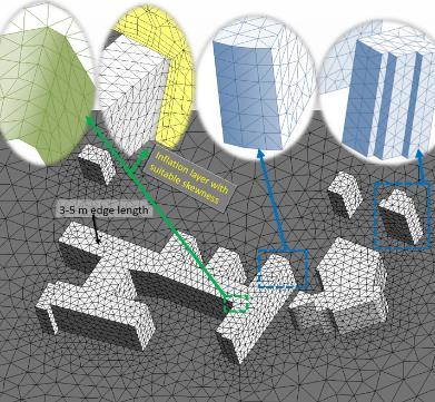


22 Urban Simulation: Wind field and Urban Climate CFD Simulation Simplification Geometry Simplification & Meshing Urban Data platform Visualisation Simulation


23 Urban Simulation: Wind field and Urban Climate Beyond Buildings: 3D Landscape Model L. Rothengaß, Master Thesis Vermessung Generierung und Evaluierung eines 3D-Landschaftsmodells für eine CFD-Windsimulation

24 Behind the Scenes Building Blocks Visualization Simulation 3D Building Model Measurements / Sensors

 06.10.")
25 Sensor Things Linking 3D building model and Sensor Data from CPS Building interior and sensors CO2 measures (ventilation system)

")
26 Example Moving Sensors (ebike) Sensor Things

27 HFT Research Team Coors Smart Cities need Smart People Researchers (external funding) Nora Bartke Habib Dastageeri Pithon Kabiro Raul Piepereit Preston Rodrigues, PhD Dr. Sven Schneider Rosanny Sihombing Parag Wate Joe Thunyathep Santhanavanich Patrick Würstle PhD Scholarship Landesgraduiertenkolleg Athanasios Koukofikis Shubhi Harbola Master Students Lukas Rothengass Matthias Betz Matthias Fitzky Martin Storz

28 SDSC 2018 / GeoDelft


29 Gefördert durch Contact Prof. Dr. Volker Coors 29
Geometrieprüfung von Gebäudemodellen der Länder
 HFT Forschung Geometrieprüfung von Gebäudemodellen der Länder Volker Coors, HFT Stuttgart AdV-Workshops der PG 3D-Geobasisdaten PG ATKIS-DOP, Limburg, 27.2.2017 1 Motivation Anwendungen von 3D-Stadtmodellen
Hochschule für Technik Stuttgart HFT Forschung
 HFT Forschung 1 Web-basierte 3D-Visualisierung Standard 3DPS WebMap Service für 3D-Stadt- und -Landschaftsmodelle Zur Darstellung von Bildern wird kaum noch über verschiedene Formate wie png, jpg und tif
3D-Portrayal Service Ein neuer OGC Standard für client- und serverseitiges Rendering von Geodaten
 HFT Forschung 3D-Portrayal Service Ein neuer OGC Standard für client- und serverseitiges Rendering von Geodaten V. Coors, Workshop 3D-Stadtmodelle, 9.11.2016 1 HFT Forschung Überblick Wozu ein neuer Standard?
Possible Contributions to Subtask B Quality Procedure
 Possible Contributions to Subtask B Quality Procedure aeteba - Energy Systems, Germany Elmar Sporer zafh.net Stuttgart, Germany Dr. Dirk Pietruschka 1/14 aeteba - Consortium of different companies - Turnkey
3DPortrayalService Ein neuer OGC Standard zur interoperablen 3D- Visualisierung
 3DPortrayalService Ein neuer OGC Standard zur interoperablen 3D- Visualisierung V. Coors 12. GeoForum MV 2016 4.4.2016 Rostock-Warnemünde Übersicht Wozu ein neuer Standard? Wie wird ein Standard beim OGC
Webbasierte Exploration von großen 3D-Stadtmodellen mit dem 3DCityDB Webclient
 Webbasierte Exploration von großen 3D-Stadtmodellen mit dem 3DCityDB Webclient Zhihang Yao, Kanishk Chaturvedi, Thomas H. Kolbe Lehrstuhl für Geoinformatik www.gis.bgu.tum.de 11/14/2015 Webbasierte Exploration
SimStadt Energiesimulation von Stadtquartieren
 SimStadt Energiesimulation von Stadtquartieren 1 SIMSTADT SIMSTADT - Energiesimulation von Stadtquartieren Geldgeber: Bundesministerium für Wirtschaft und Technoloie (BMWi) Ausschreibung: EnEff:Stadt /
 3D City Model Berlin Spatial Data Infrastructure Berlin: The 3D City Model ERDF Project Strategic Goal 3D City Model Berlin Strategic Goal Use of 3D City Model for: City and Urban Planning, Political Issues
Aktuelle Entwicklungen aus der ISO-Normung. Wolfgang Kresse, Hochschule Neubrandenburg kresse@hs-nb.de
 Aktuelle Entwicklungen aus der ISO-Normung Wolfgang Kresse, Hochschule Neubrandenburg kresse@hs-nb.de ISO International Organization for Standardization isos = gleich 1926: International Federation of
(Software) Architektur der Dinge. Roland Graf / Simon Kranzer IKT-Forum 2016 I(o)T for Industry - Von IT zu IoT
 Architektur der Dinge. Roland Graf / Simon Kranzer IKT-Forum 2016 I(o)T for Industry - Von IT zu IoT") (Software) Architektur der Dinge Roland Graf / Simon Kranzer IKT-Forum 2016 I(o)T for Industry - Von IT zu IoT Hardware Mainframe Speichersysteme Rechner Kopplung Zentralisierung Anwendungsprogramme Software
(Software) Architektur der Dinge Roland Graf / Simon Kranzer IKT-Forum 2016 I(o)T for Industry - Von IT zu IoT Hardware Mainframe Speichersysteme Rechner Kopplung Zentralisierung Anwendungsprogramme Software
3D Stadtmodelle als Geobasisdaten
 Fakultät Vermessung, Informatik, Mathematik 3D Stadtmodelle als Geobasisdaten Prof. Dr. Volker Coors 9. Vermessungsingenieurtag, 9.11.2012 1 Von 2D nach 3D Quelle: Freie und Hansestadt Hamburg, Landesbetrieb
Urbane Energiesimulationen basierend auf 3D-Stadtmodellen
 HFT Forschung Urbane Energiesimulationen basierend auf 3D-Stadtmodellen Geoinformatik Prof. Dr. Volker Coors Nachhaltige Energietechnik Prof. Dr. Ursula Eicker M. Eng. Romain Nouvel, 3D Model LoD2 Ludwigsburg
Air quality and Smart Cities
 Air quality and Smart Cities Projects of RheinEnergie AG Alexander Stankiewicz Content EU-Project GrowSmarter WP2 Energy GrowSmarter Call Project area What are our goals Energy refurbishment Energy SmartCity
Neue urbane Energiesimulations-Plattform für CityGML-Stadtmodelle. Zafh.net M. Sc. Romain Nouvel,
 Neue urbane Energiesimulations-Plattform für CityGML-Stadtmodelle Zafh.net M. Sc. Romain Nouvel, Darmstadt, den 19.11.2015 Motivationen 1. CityGML 3D Stadtmodelle nutzen und analysieren, um auf das volle
Lufft UMB Sensor Overview
 Lufft Sensor Overview Wind Radiance (solar radiation) Titan Ventus WS310 Platinum WS301/303 Gold V200A WS300 WS400 WS304 Professional WS200 WS401 WS302 Radiance (solar radiation) Radiation 2 Channel EPANDER
SARA 1. Project Meeting
 SARA 1. Project Meeting Energy Concepts, BMS and Monitoring Integration of Simulation Assisted Control Systems for Innovative Energy Devices Prof. Dr. Ursula Eicker Dr. Jürgen Schumacher Dirk Pietruschka,
Applying Pléiades in the ASAP project HighSens
 Applying Pléiades in the ASAP project HighSens Highly versatile, new satellite Sensor applications for the Austrian market and International Development (Contract number: 833435) Dr. Eva Haas, GeoVille
Browser- gestützte Visualisierung komplexer Datensätze: Das ROAD System
 AG Computeranwendungen und QuanLtaLve Methoden in der Archäologie 5. Workshop Tübingen 14. 15. Februar 2014 Browser- gestützte Visualisierung komplexer Datensätze: Das ROAD System Volker Hochschild, Michael
A geological 3D-information system for subsurface planning in urban areas - case study Darmstadt (Hesse, Germany)
") A geological 3D-information system for subsurface planning in urban areas - case study Darmstadt (Hesse, Germany) Rouwen Lehné, Hanna Kuhn, Heiner Heggemann & Christian Hoselmann 3 rd European meeting
A geological 3D-information system for subsurface planning in urban areas - case study Darmstadt (Hesse, Germany) Rouwen Lehné, Hanna Kuhn, Heiner Heggemann & Christian Hoselmann 3 rd European meeting
3D Portrayal ein neuer OGC-Standard für die web-basierte Visualisierung von 3D-Stadtmodellen
 3D Portrayal ein neuer -Standard für die web-basierte Visualisierung von 3D-Stadtmodellen V. Coors Workshop 3D-Stadtmodelle Bonn, 20.11.2013 Überblick Motivation Hintergrund Was ist der 3D-Portrayal Service?
Strukturierung städtischer 3D-Geoinformationen mit CityGML
 Technische Universität Berlin Strukturierung städtischer 3D-Geoinformationen mit CityGML Prof. Dr. Thomas H. Kolbe Institut für Geodäsie und Geoinformationstechnik Technische Universität Berlin kolbe@igg.tu-berlin.de
Building management and Online simulation of buildings
 Building management and Online simulation of buildings Prof. Dr. Ursula Eicker University of Applied Sciences Stuttgart Research Centre Sustainable Energy Technologies Page 1 Energy consumption control
Zuverlässige IT-Netzwerke als Basis für sicheren Informationsaustausch im Krisenfall. Univ.-Doz. Dr. Siegfried Reich DI DI(FH) Peter Dorffinger
 Peter Dorffinger") Zuverlässige IT-Netzwerke als Basis für sicheren Informationsaustausch im Krisenfall Univ.-Doz. Dr. Siegfried Reich DI DI(FH) Peter Dorffinger About Salzburg Research Independent research and technology
Zuverlässige IT-Netzwerke als Basis für sicheren Informationsaustausch im Krisenfall Univ.-Doz. Dr. Siegfried Reich DI DI(FH) Peter Dorffinger About Salzburg Research Independent research and technology
SMART CITIES: AUSTRIAN AND EUROPEAN APPROACHES IN R&D FUNDING
 SMART CITIES: AUSTRIAN AND EUROPEAN APPROACHES IN R&D FUNDING Johannes Bockstefl Deputy team leader Energy & Sustainability, Thematic Programmes, FFG Vienna, July 8, 2014 0 OVERVIEW The Austrian Smart
Smarte Geoinformationsdienste für nachhaltige Mobilität im transdisziplinären Forschungsprojekt i_city der HFT Stuttgart
 HFT Forschung Smarte Geoinformationsdienste für nachhaltige Mobilität im transdisziplinären Forschungsprojekt i_city der HFT Stuttgart V. Coors, 20 Jahre InGeoForum, 20.6.2017 1 HFT Forschung Rückblick:
3D Portrayal Service Ein neuer OGC Standard zur interoperablen 3D-Visualisierung
 3D Portrayal Service Ein neuer OGC Standard zur interoperablen 3D-Visualisierung Volker Coors Hochschule für Technik Stuttgart Schellingstr. 24 70174 Stuttgart Fraunhofer-Institut für Graphische Datenverarbeitung
3D-Stadtmodelle als Unterstützung der Energieplanung von Kommunen
 3D-Stadtmodelle als Unterstützung der Energieplanung von Kommunen Prof. Dr. Volker Coors, HFT Stuttgart Wo-Kongress 6. Juni 2013, Wissenschaftspark Gelsenkirchen 1 Energiebedarfssimulation auf Basis von
Generierung und Evaluierung dreidimensionaler Landschaftsmodelle für eine CFD-Windsimulation
 Generierung und Evaluierung dreidimensionaler Landschaftsmodelle für eine CFD-Windsimulation Master-Arbeit als Prüfungsleistung an der Hochschule für Technik und Stuttgart nach der SPO-2012 ausgeführt
Research on IF-MAP. Ingo Bente (Trust@FHH) 15.04.2011, University of Frankfurt
 15.04.2011, University of Frankfurt") Research on IF-MAP Ingo Bente (Trust@FHH) 15.04.2011, University of Frankfurt Introduction 2011/04/15 ESUKOM 2 Trust@FHH Research Group Team Chair: Prof Dr. Josef von Helden 3 research associates 4 student
Research on IF-MAP Ingo Bente (Trust@FHH) 15.04.2011, University of Frankfurt Introduction 2011/04/15 ESUKOM 2 Trust@FHH Research Group Team Chair: Prof Dr. Josef von Helden 3 research associates 4 student
3D Stadtmodelle für Wärmebedarfssimulationen
 HFT Forschung 3D Stadtmodelle für Wärmebedarfssimulationen Claudia Schulte, HFT Stuttgart, Institut für Angewandte Forschung (IAF) Prof. Dr. Volker Coors, HFT Stuttgart, Zentrum für Geodäsie und Geoinformatik
CityGML Ein Standard für virtuelle 3D-Stadtmodelle
 Technische Universität Berlin CityGML Ein Standard für virtuelle 3D-Stadtmodelle Prof. Dr. Thomas H. Kolbe Institut für Geodäsie und Geoinformationstechnik Technische Universität Berlin kolbe@igg.tu-berlin.de
Wireless Sensor Netzwerke für den industriellen Einsatz
 Wireless Sensor Netzwerke für den industriellen Einsatz Prof. Andreas Rüst Leiter Forschungsgruppe Internet-of-Things Zürcher Hochschule für angewandte Wissenschaften Institute of Embedded Systems Winterthur,
GIS-based Mapping Tool for Urban Energy Demand
 GIS-based Mapping Tool for Urban Energy Demand Building Services, Mechanical and Building Industry Days Conference Johannes Dorfner Debrecen, 14 October 2011 Outline 1. Motivation 2. Method 3. Result 4.
Smart Cities. Deutsch-Chinesischer Workshop
 Deutsch-Chinesischer Workshop Smart Cities STUTTGART WILLI-BLEICHER-STR. 20 GEWERKSCHAFTSHAUS KONFERENZRAUM 3+4 18. APRIL 2018, 09.30-16:30 UHR 19. APRIL 2018, 09:00-13:30 UHR Deutsch-Chinesischer Workshop
Office 365 Dynamics 365 Azure Cortana Intelligence. Enterprise Mobility + Security Operations Mgmt. + Security
 Office 365 Dynamics 365 Azure Cortana Intelligence Enterprise Mobility + Security Operations Mgmt. + Security API Application Availability Bottomless Storage Identity Management Full hybrid
Novell for Education. Beratung - Systembetreuung - Supporting Implementation von Ausbildungsschienen für österreichische Schulen
 Novell for Education 08.10.2007 Wolfgang Bodei / Thomas Beidl Folie 1 The Goal of n4e is an effective increase of quality in terms of Design Operation Administration of Novell based school network infrastructures
Trag Werk Holz Bau. Trag Werk Holz Bau. Trag Werk Holz Bau. Trag Werk Holz Bau. Trag Werk Holz Bau. Trag Werk Holz Bau. Trag Werk Holz Bau
 Contents URBAN WOOD Multi Storey Timber Buildings WOOD & THE CITY... Wood Based Building Design for Sustainable Urban Development Training & Research Program ˆURBAN WOOD Y. Amino, M.eng. Dr.sc.tech Contents
3D-Stadtmodelle heute. Eine Standortbestimmung
 3D-Stadtmodelle heute. Eine Standortbestimmung Dr.-Ing. Egbert Casper CITIS, Remscheid Sprecher Special Interest Group 3D Intergeo Eindrücke Was soll man davon halten? Buzzwords folgen Hype-Kurven! 3D-Stadtmodelle
Wärmebedarfsprognose für Gebäude und Stadtquartiere, Entwicklungen an der HFT Stuttgart
 Wärmebedarfsprognose für Gebäude und Stadtquartiere, Entwicklungen an der HFT Stuttgart Prof. Dr. habil. Ursula Eicker Zentrum für angewandte Forschung nachhaltige Energietechnik Hochschule für Technik
MULTI PHYSICS SIMULATION IN MANUFACTURING
 MULTI PHYSICS SIMULATION IN MANUFACTURING A. Junk CADFEM GmbH Contents Manufacturing Multi Physics in Manufacturing Manufacturing example: Residual Stresses in an Induction Hardened Roll Set up Conclusions
Simulating the Idle: A New Load Case for Vehicle Thermal Management
 Simulating the Idle: A New Load Case for Vehicle Thermal Management Jan Eller FKFS / IVK University of Stuttgart Thomas Binner and Heinrich Reister Daimler AG Nils Widdecke and Jochen Wiedemann FKFS /
GrowSmarter Call Smart Cities and Communities
 GrowSmarter Call Smart Cities and Communities Holistic integration of Energy, Mobility and ICT in huge lighthouse projects, being the first of it s kind (first mover risk) It is an implementation project
Energy efficiency in buildings and districts Key technologies within a case study of the Young Cities Project, Iran
 Energy efficiency in buildings and districts Key technologies within a case study of the Young Cities Project, Iran Prof. Dr.-Ing. Christoph Nytsch-Geusen UdK Berlin, Institut für Architektur und Städtebau
Industrie 4.0 Predictive Maintenance. Kay Jeschke SAP Deutschland AG & Co. KG., Februar, 2014
 Industrie 4.0 Predictive Maintenance Kay Jeschke SAP Deutschland AG & Co. KG., Februar, 2014 Anwendungsfälle Industrie 4.0 Digitales Objektgedächtnis Adaptive Logistik Responsive Manufacturing Intelligenter
Stadtweite Wärmebedarfsprognose auf Basis von 3D-Stadtmodellen
 Stadtweite Wärmebedarfsprognose auf Basis von 3D-Stadtmodellen Prof. Dr. habil. Ursula Eicker Zentrum für angewandte Forschung nachhaltige Energietechnik Hochschule für Technik Stuttgart Forschungsfelder
Studien- und Prüfungsordnung
 Schellingstrasse D-01 T +9 (0)11 89 0 F +9 (0)11 89 www.hft-stuttgart.de info@hft-stuttgart.de Hochschule für Technik Studien- und Prüfungsordnung Master International Project Management (Building, Real
Lehrangebot. Fachgebiet Informationssysteme Prof. Dr. Norbert Fuhr
 Lehrangebot Fachgebiet Informationssysteme Prof. Dr. Norbert Fuhr N. Fuhr, U. Duisburg-Essen Lehrangebot 1 Lehrangebot des FG Informationssysteme Datenbanken Internet-Suchmaschinen Information Retrieval
COP 21 Get the citizens involved! Example 1: evaluated rest waste amounts and impact for CO2-dropping rates
 14-09-2016 EnviroInfo HTW BERLIN green with IT e. V. Charlottenstr. 16, 10117 Berlin kommunikation@green-with-it.de Jörg Lorenz CEO COP 21 Get the citizens involved! Example 1: evaluated rest waste amounts
Storage Virtualisierung 2.0. Highway to Cloud?!
 Storage Virtualisierung 2.0 Highway to Cloud?! Ziel dieses Vortrags Überblick über die Anforderungen von Change IT an die Storage-Infrastruktur Die Gründe für rasantes Datenwachstum Storage Virtualisierung
Industrie 4.0 The Impact of Digitization on Sustainable Value Creation
 Industrie 4.0 The Impact of Digitization on Sustainable Value Creation INTANGIBLES: THE EUROPEAN STATE OF THE ART 2nd International Policy Conference Frankfurt am Main, 12. September 2017 Professor Dr.
CityGML Semantische Modellierung. Prof. Dr. Volker Coors, 11. Februar 2009 EDV in der Stadtplanung - Workshop CityGML
 CityGML Prof. Dr. Volker Coors, 11. Februar 2009 EDV in der Stadtplanung - Workshop CityGML 1 Semantische Modellierung 3D-Visualisierung ist nur ein Teil-Aspekt der Modellierung Visuelle Eigenschaften:
Vom Sensor zur thematischen Karte
 Vom Sensor zur thematischen Karte deegree SOS und WMS bringen Sensordaten und Kartodiagramme ins Geoportal Jens Fitzke fitzke@lat-lon.de http://www.lat-lon.de/ Agenda Kurze Vorstellung Ausgangsituation
A central repository for gridded data in the MeteoSwiss Data Warehouse
 A central repository for gridded data in the MeteoSwiss Data Warehouse, Zürich M2: Data Rescue management, quality and homogenization September 16th, 2010 Data Coordination, MeteoSwiss 1 Agenda Short introduction
3D webservices - where do we stand? Emmanuel Belo +41 21 619 10 25 emmanuel.belo@camptocamp.com
 3D webservices - where do we stand? Emmanuel Belo +41 21 619 10 25 emmanuel.belo@camptocamp.com Google Maps 2/32 Google Maps 3/32 Here maps (Nokia) 4/32 OpenWebGlobe 5/32 Cesium 6/32 Was wollen wir im
Das Internet der Dinge als Beschleuniger der Digitalisierung - Status Quo und Ausblick -
 Das Internet der Dinge als Beschleuniger der Digitalisierung - Status Quo und Ausblick - Nils Herzberg Global Head of IoT Go-To-Market Strategy - SAP SE Bildquelle: Hagleitner Bildquelle: Kaeser Kompressoren
Privacy-preserving Ubiquitous Social Mining via Modular and Compositional Virtual Sensors
 Privacy-preserving Ubiquitous Social Mining via Modular and Compositional s Evangelos Pournaras, Iza Moise, Dirk Helbing (Anpassung im Folienmaster: Menü «Ansicht» à «Folienmaster») ((Vorname Nachname))
Workflows mit BPMN & Business Rules mit DMN - Open Source und in Action mit Camunda BPM.
 Workflows mit BPMN & Business Rules mit DMN - Open Source und in Action mit Camunda BPM bernd.ruecker@camunda.com Hallo! Bernd Rücker Co-Founder of camunda > 10+ years experience with workflow and Java
Lehrangebot. Fachgebiet Informationssysteme Prof. Dr. Norbert Fuhr
 Lehrangebot Fachgebiet Informationssysteme Prof. Dr. Norbert Fuhr N. Fuhr, U. Duisburg-Essen Lehrangebot 1 Lehrangebot des FG Informationssysteme Datenbanken Internet-Suchmaschinen Information Retrieval
Lernmodule aus Geomedien. Real vs Virtual Worlds Earth vs Model. 3/31/2016. Interfaculty Department of Geoinformatics
 Josef Strobl University of Salzburg Interfaculty Department of Studien @Z_GIS Real vs Virtual Worlds Earth vs Model Bachelor Master PhD PD UNIGIS professional UNIGIS MSc Bachelor Geography PostDoc Research
Living LaB Ludwigsburg
 6th Agoria Smart Cities Forum & Award Living LaB Ludwigsburg Dr. Andrea Braeuning, Robert Bosch GmbH March 1st, 2018; Brussels Living Lab Ludwigsburg digitalizes the city. Does it? Data something to cope
in Dano, Burkina Faso
 Energy Balance Measurements and Radiosoundings in Dano, Burkina Faso Martin Kohler, Norbert Kalthoff, Stephanie Heidt Forschungszentrum Karlsruhe (FZK) Institute for Meteorology and Climate Research (IMK-TRO)
Concepts for cities in times of climate change
 IBA HAMBURG GMBH Concepts for cities in times of climate change Kai Michael Dietrich Livable Cities 16, Aarhus IBA HAMBURG GMBH City of Hamburg: A Grand Maritime Tradition IBA HAMBURG GMBH 3 Location of
Climate Change and Air Quality
 Climate Change and Air Quality Renate Forkel Richard Knoche Peter Suppan Hans Peter (HaPe) Schmid TU Munich Institute for Meteorology & Climate Research KIT / Research Centre Karlsruhe Climate Change relates
Realtime Security for Enterprise Networks based upon the Correlation of Metadata
 Realtime Security for Enterprise Networks based upon the Correlation of Metadata Josef von Helden (University of Applied Sciences and Arts, Hanover) 15.06.2011, München Introduction 2011/06/15 ESUKOM 2
entwine for the open minded
 cdn dualstream html5 player processing youtube video portal lms metadata live on demand learning recording annotation 9employees 3 continents 80 000 hours of content 14 happy clients produced per 2011
Inhaltsverzeichnis. Vorwort Einleitung CityGML als OGC-Norm Grundlagen Das Objektmodell von CityGML...
 Vorwort... 5 1 Einleitung... 13 2 CityGML als OGC-Norm... 15 2.1 Das Open Geospatial Consortium... 15 2.2 Kurze Geschichte von CityGML... 16 2.3 GML als Basis... 17 2.4 Normen ringsherum... 18 2.5 Alternativen
Workshop on Copernicus and the CAP. A technology vision for IACS
 Workshop on Copernicus and the CAP on 17 th March 2017 A technology vision for IACS Wolfgang Ehbauer StMELF Bavaria, Germany Outline 1. Some figures about Bavaria 2. Automatic methods in use 3. Tests with
Power, space heat and refurbishment: Tools and methods to include energy in urban planning. Thomas Hamacher
 Power, space heat and refurbishment: Tools and methods to include energy in urban planning Thomas Hamacher Problem Statement 2 New developments Urban planning Smaller scale units in the infrastructure
Studien- und Prüfungsordnung
 Schellingstrasse 4 D-70174 T +49 (0)711 896 0 F +49 (0)711 896 666 www.hft-stuttgart.de info@hft-stuttgart.de Hochschule für Technik Studien- und Prüfungsordnung Master Smart City Solutions Stand: 13.06.018
DEMMIN. Durable Environmental Multidisciplinary Monitoring Information Network
 DEMMIN Durable Environmental Multidisciplinary Monitoring Information Network German Aerospace Center (DLR) German Remote Sensing Data Center (DFD) Department of Ground Segment (BN) Folie 1 Neustrelitz
1. Was wird gebraucht? 2. Was wird nicht gebraucht? 3. Wie sollen wir weiter machen?
 Deutsches Normungs Panel DNP Konferenz 2. Mai 2016 Normung für die Industrie 4.0 Status Quo und Ausblick Diskussionsbeitrag M. Reigl, Siemens AG Berlin, 2016-05-02 1. Was wird gebraucht? 2. Was wird nicht
Dr. Jens Hündling Senior Sales Consultant. DOAG Apps 2011 Berlin, 05. Mai 2011
 Business Management: Grundlagen, Business Process Life Cycle, Überblick Oracle BPM Suite 11g Dr. Jens Hündling Senior Sales Consultant DOAG Apps 2011 Berlin, 05. Mai 2011
THE PRINICPLE OF OPENNESS.
 Credits: Grafik Linz_Open Commons: CC-by: Quelle Stadt Linz, CC-by Logo: CC-by: Creative Commons THE PRINICPLE OF OPENNESS. Local Data in the Open Commons Region Linz http://creativecommons.org/licenses/by/3.0/at/
jasimasolutions Simulation based process optimization for the agri food sector jasimabeverageplanner jasima Solutions Spin Off from
 jasima Solutions Spin Off from BIBA - Bremer Institut für Produktion und Logistik GmbH Simulation based process optimization for the agri food sector jasimabeverageplanner Torsten Hildebrandt Torsten.Hildebrandt@.de
Die Energiewende vorzeigen.
 Die Energiewende vorzeigen. Dr. Christian Kurz, Ph.D., R&D Manager Green Energy Lab www.greenenergylab.at Eine FTI-Initiative des Klima- und Energiefonds Eine Vorzeigeregion Energie mit idealen Voraussetzungen.
logarithmo ! 1 Equipping the energy sector with smart applications logarithmo
 . Equipping the energy sector with smart applications! 1 Vorstellung 1 Portfolio 2 Unsere Kunden! 2 Die Zukunft ist datenbasiert nutzen Sie bereits das volle Potenzial Ihrer Datenbasis? Im Kontext der
MULTI-SENSOR KONZEPT EINSATZMÖGLICHKEITEN UND GRENZEN 09. MÄRZ 2018 RALF PFISTERER
 MULTI-SENSOR KONZEPT EINSATZMÖGLICHKEITEN UND GRENZEN 09. MÄRZ 2018 RALF PFISTERER Agenda BCDS Wer ist das? MSK Was steckt dahinter? Grenzen bitte beachten! Zusammenfassung und Ausblick 2 Transport Data
Waldwissen.net (Forest-knowledge.net)
") Waldwissen.net (Forest-knowledge.net) Conference of Directors of State Forest Research Institutes, Vienna, July 5-6th 2004 project idea Establish an internet-based, scientifically sound, comprehensive
Waldwissen.net (Forest-knowledge.net) Conference of Directors of State Forest Research Institutes, Vienna, July 5-6th 2004 project idea Establish an internet-based, scientifically sound, comprehensive
Power, space heat and refurbishment: Tools and methods to include energy in urban planning. Thomas Hamacher
 Power, space heat and refurbishment: Tools and methods to include energy in urban planning Thomas Hamacher Problem Statement 2 1 Problem Statement 3 Problem Statement 4 2 New developments Urban planning
VALUE ADDED SOFTWOOD
 VALUE ADDED SOFTWOOD PRODUKT UND MARKTTRENDS IN DER EUROPÄISCHEN HOLZINDUSTRIE Dr. Joerg Peter Schmitt www.innomis.one 40 JAHRE VEUH 08. Juli 2016 Wien 1 VALUE ADDED SOFTWOOD PRODUKT UND MARKTTRENDS IN
WE SHAPE INDUSTRY 4.0 BOSCH CONNECTED INDUSTRY DR.-ING. STEFAN AßMANN
 WE SHAPE INDUSTRY 4.0 BOSCH CONNECTED INDUSTRY DR.-ING. STEFAN AßMANN Bosch-Definition for Industry 4.0 Our Seven Features Connected Manufacturing Connected Logistics Connected Autonomous and Collaborative
EAM-Vorlesung (SS2017)
") EAM-Vorlesung (SS2017) V4: TOGAF und das Metamodel Vassilios Goumas Frankfurt University of Applied Science 1 V4: Verlauf Was ist ein Metamodell Aufbau des Metamodells in TOGAF Aufteilung nach Core Metamodel
EAM-Vorlesung (SS2017) V4: TOGAF und das Metamodel Vassilios Goumas Frankfurt University of Applied Science 1 V4: Verlauf Was ist ein Metamodell Aufbau des Metamodells in TOGAF Aufteilung nach Core Metamodel
Geodatenbankunterstützung für die geotechnische Bewertung von Massenbewegungen mit Hilfe eines Web Geological Feature Server (WGFS)
") Geodatenbankunterstützung für die geotechnische Bewertung von Massenbewegungen mit Hilfe eines Web Geological Feature Server (WGFS) Björn Broscheit Universität Osnabrück Institut für Geoinformatik und
Geodatenbankunterstützung für die geotechnische Bewertung von Massenbewegungen mit Hilfe eines Web Geological Feature Server (WGFS) Björn Broscheit Universität Osnabrück Institut für Geoinformatik und
IT-gestützte Lehre Notwendiger Wandel hin zu einem Internet der Lerndienste ( aus der Cloud/SOA-basiert )
") IT-gestützte Lehre Notwendiger Wandel hin zu einem Internet der Lerndienste ( aus der Cloud/SOA-basiert ) Dr. Volker Zimmermann, IMC AG Forum IT-gestützte Lehre und Wissensmanagement, FH Deggendorf Obama
IT-gestützte Lehre Notwendiger Wandel hin zu einem Internet der Lerndienste ( aus der Cloud/SOA-basiert ) Dr. Volker Zimmermann, IMC AG Forum IT-gestützte Lehre und Wissensmanagement, FH Deggendorf Obama
Entwicklung ISO/OGC-konformer Metadaten und Katalogdienste
 19. September 2006 Entwicklung ISO/OGC-konformer Metadaten und Katalogdienste Wilhelmstraße 56 D-53721 Siegburg http://www.supportgis.de Tel.:+49(0)2241-2594- 0 Fax.:+49(0)2241-2594-29 thiele@supportgis.de
CityGML-Daten als Grundlage für webbasierte Visualisierungen
 CityGML-Daten als Grundlage für webbasierte Visualisierungen Geonetzwerk Münsterland Thementag 3D Christian Dahmen Christoph Uhlenküken Münster, 17. November 2017 connecting worlds CityGML-Daten als Grundlage
Towards Modular Supercomputing with Slurm
 Towards Modular Supercomputing with Slurm 2017-09-25 Dorian Krause et al., Jülich Supercomputing Centre, Forschungszentrum Jülich Dual-Architecture Supercomputing Facility IBM Power 4+ JUMP, 9 TFlop/s
DATA ANALYSIS AND REPRESENTATION FOR SOFTWARE SYSTEMS
 DATA ANALYSIS AND REPRESENTATION FOR SOFTWARE SYSTEMS Master Seminar Empirical Software Engineering Anuradha Ganapathi Rathnachalam Institut für Informatik Software & Systems Engineering Agenda Introduction
Visualisierung und Vorhersagesteuerung mit Delft FEWS in der Schweiz
 Federal Department of the Environment, Transport, Energy and Communications DETEC Federal Office for the Environment FOEN Visualisierung und Vorhersagesteuerung mit Delft FEWS in der Schweiz Martin Ebel,
Organisation und Integration von Simulationsaufgaben. Michael Moltenbrey,
 Praktikum Wissenschaftliches Rechnen Organisation und Integration von Simulationsaufgaben 31.1.2008, 1 Vorbesprechnung und Anmeldung Dr Ralf-Peter Mundani mundani@tum de Dr. Ralf Peter Mundani, mundani@tum.de
Entwicklung eines 3D-Geoinformationssystems für Gefahrensituationen im In- und Outdoorbereich im Rahmen von WALK
 Entwicklung eines 3D-Geoinformationssystems für Gefahrensituationen im In- und Outdoorbereich im Rahmen von WALK Mariusz Baldowski Hochschule für Angewandte Wissenschaften Hamburg Dept. Informatik mariusz.baldowski@haw-hamburg.de
Open Source in der Cloud
 Open Source in der Cloud Jens Fitzke fitzke@lat-lon.de http://www.lat-lon.de/ über lat/lon Uni Bonn spin-off als GbR (2000) - 2004: GmbH GDI/OGC/ISO-Kompetenz + Freie Software Beratung, Software-/Lösungsentwicklung,
CO2 Monitoring und Reporting auf Basis von 3D-Stadtmodellen
 CREATE MAINTAIN DISTRIBUTE AK 3D-Stadtmodelle CO2 Monitoring und Reporting auf Basis von 3D-Stadtmodellen Richard Redweik rredweik@virtualcitysystems.de virtualcitysystems Übersicht Experten und Lösungsanbieter
Algorithms for graph visualization
 Algorithms for graph visualization Project - Orthogonal Grid Layout with Small Area W INTER SEMESTER 2013/2014 Martin No llenburg KIT Universita t des Landes Baden-Wu rttemberg und nationales Forschungszentrum
From Mapping to Metadata, From Simple to Enterprise Portals? - A one Stop Solution using Portlet Technology*
 From Mapping to Metadata, From Simple to? - A one Stop Solution using Portlet Technology* (* for download images have been compressed; quality decreased) Hans Plum plum@lat-lon.de www.lat-lon.de www.deegree.org
Stadt quo vadis? Edeltraud Stiftinger, Dezember Siemens AG Alle Rechte vorbehalten
 Stadt quo vadis? Edeltraud Stiftinger, Dezember 00 Siemens AG 00. Alle Rechte vorbehalten Megatrends bestimmen maßgeblich die Zukunft unseres Planeten Urbanisierung Siemens AG 00. Alle Rechte vorbehalten
IOT IN DER ÖFFENTLICHEN VERWALTUNG EINE VISION. Gerd Rampelt. Grassau, February SAG PUBLIC ACCOUNT PLANNING WORKSHOP - v1
 IOT IN DER ÖFFENTLICHEN VERWALTUNG EINE VISION Gerd Rampelt Grassau, February 22 23 2018 SAG PUBLIC ACCOUNT PLANNING WORKSHOP - v1 TREIBER IM ÖFFENTLICHEN SEKTOR 2 SAG PUBLIC ACCOUNT PLANNING WORKSHOP
Cisco Intelligent Contact Management Solutions. ICM Internet Channels. Interactive E-Commerce und Internet Customer Contact
 Cisco Intelligent Contact Management Solutions ICM Internet Channels ICM Internet Channels Interactive E-Commerce und Internet Customer Contact 1999, Cisco Systems, Inc. 1 1999, Network-to-Desktop Cisco
Die Bedeutung von INSPIRE und Geodiensten für die Wirtschaft. Christian Kleine Ansprechpartnerworkshop GDI Brandenburg April 11, 2017
 Die Bedeutung von INSPIRE und Geodiensten für die Wirtschaft Christian Kleine Ansprechpartnerworkshop GDI Brandenburg April 11, 2017 Agenda About HERE TN-ITS INSPIRE und GDI Zusammenfassung HERE in numbers