Open Source GI and Cartography. Georg Gartner TU Wien
|
|
|
- Christina Kohl
- vor 8 Jahren
- Abrufe
Transkript
1 Open Source GI and Cartography Georg Gartner TU Wien

2 Outline 1. Introduction 2. Free and Open Source Software for GI and cartography 3. Open standards and technologies for GI and Cartography 4. Open Software for GI and Cartography 5. Case studies in urban planning

3 1. What is Free and Open Source Software? Four essential freedoms 1 : The freedom to run the program, for any purpose (Freedom 0) The freedom to study how the program works, and change it to make it do what you wish (Freedom 1) The freedom to redistribute copies so you can help your neighbor (Freedom 2) The freedom to distribute copies of your modified versions to others (Freedom 3) Access to the source code is a precondition for Freedom 1 and 3. A program is free software if users have all of these freedoms. 1.
 Access to the source code is a precondition for Freedom 1 and 3.")
4 Definition Free software is a matter of the user s freedom to run, copy, distribute, study, change and improve the software. Free software is a mater of liberty, not price. free speech vs. free beer


5 Google Maps (APIs) is free, but not a free software. Terms of Use

6 Bing Map? Not! Privacy and Legal

7 2. Free and Open Source Software for Geospatial Open source GIS provides accessibility, low cost solutions and lowers the entry barriers for the use of geospatial technologies for all. Relevant communities Open Geospatial Consortium (OGC) Open Source Geospatial Foundation (OSGeo) Research communities: ICA Working Group on Open Source Geospatial Technologies
 Open Source Geospatial Foundation")
8 OGC The Open Geospatial Consortium, Inc. (OGC) is a non-profit, international, voluntary consensus standards organization that is leading the development of standards for geospatial and location based services. Mission To serve as a global forum for the collaboration of developers and users of spatial data products and services, and to advance the development of international standards for geospatial interoperability.

9 OGC s standards Geography Markup Language GML Web Map Service (WMS) Web Coverage Service (WCS) Web Feature Service (WFS) Location Services (OpenLS).
. http://www.opengeospatial.")
10 OSGeo The OSGeo is a not-for-profit organization whose mission is to support and promote the collaborative development of open geospatial technologies and data. provides financial, organizational and legal support to the broader open source geospatial community. Hosting the FOSS4G conferences (Free and Open Source Software for Geospatial)

11 OSGeo s Projects Web Mapping Deegree, Geomajas, GeoServer, Mapbender, MapBuilder, MapFish, MapGuide Open Source, MapServer, OpenLayers Desktop Applications GRASS GIS, OSSIM, Quantum GIS, gvsig Geospatial Libraries FDO, GDAL/OGR, GEOS, GeoTools, MetaCRS, PostGIS Metadata Catalog GeoNetwork Other Projects Public Geospatial Data, Education and Curriculum

12 ICA Working Group on Open Source Geospatial Technologies The WG aims to promote multi-national holistic research in free and open source geospatial technologies in order to make accessible the latest developments in open source tools to the wider cartographic community. The WG attempts to enhance the usage of free and open source geospatial tools among the cartographic community worldwide, especially for education. A serial of conferences and workshops

13 3. Open standards and technologies GML (current version 3.2.1) an XML grammar for expressing geographical features Used as an open interchange format for transmitting geographic data on the Internet GML was adopted as an International Standard (ISO 19136:2007) in Ordnance Survey of GB use GML as the (only) format for supply of MasterMap data
 in 2007. Ordnance Survey of GB use GML as the (only) format for supply of MasterMap data 1 1.")
14 3. Open standards and technologies KML (Keyhole Markup Language ) a language for the visualization of geographic information tailored for "Google Earth". complements GML: KML can be used to carry GML content, and GML can be styled to KML for the purposes of presentation. SVG (Scalable Vector Graphic, by W3C) an XML-based file format for describing twodimensional vector graphics, both static and dynamic Can be used to visualize geospatial dataset (such as GML)

15 3. Open standards and technologies OGC s OpenGIS Web Services (OWS) Web Map Service (WMS 1.3.0) Provides georeferenced map images Return data types: GIF, PNG, JPEG, etc. Web Feature Service (WFS 1.1) Provides vector data on demand Return data types: GML 3.1.1, and GML Web Converage Service (WCS 1.1) Provides raster data on demand Return data types: GeoTIFF, DTED, HDF-EOS, or NITF.
 Provides raster data on demand Return data types: GeoTIFF, DTED, HDF-EOS, or NITF.")
16 3. Open standards and technologies WMS, WFS and WCS are designed as serverside mapping methods. Map (and other) requests are made through standard HTML methods 1 URL Parameters supplied within URL (GET) or hidden in document (POST) One request gives one response 1.
 or hidden in document (POST) One request gives one")

17 A WMS Example (A large image (1000 x 1000 pixels) of several cryospheric parameters in a polar stereographic projection focused on the Arctic): =1.1.1&request =GetMap&srs=EPSG:32661&format=image/gif&width=1000&height=1000&bbox= , , , &layers=sea_ice_extent_01,land,snow_extent_01,permafrost_extent,country_ borders,treeline,north_pole_geographic,arctic_circle,country_labels,geographic_features_sea

: http://nsidc.")

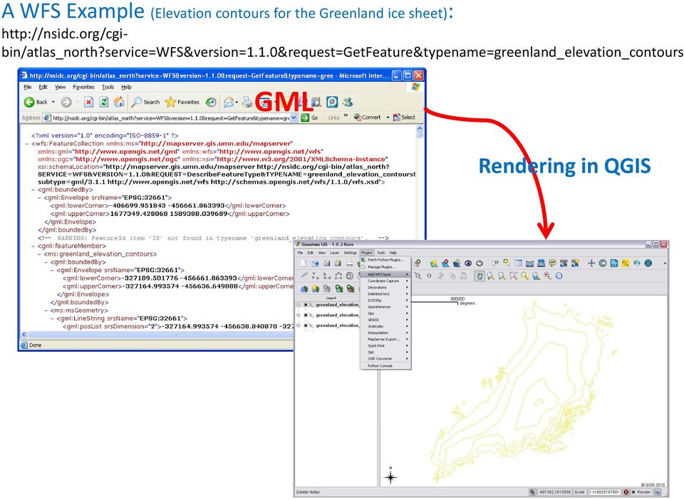
18 A WFS Example (Elevation contours for the Greenland ice sheet): GML Rendering in QGIS
19 A WCS Example (A GeoTIFF of sea ice concentration at 25-km resolution in a polar stereographic projection focused on the Arctic ) : =GetCoverage&crs=EPSG:32661&format=GeoTIFF&resx=25000&resy=25000&bbox= , , , &coverage=sea_ice_concentration_01 From:

20 3. Open standards and technologies Web Processing Service provides rules for standardizing how inputs and outputs (requests and responses) for geospatial processing services, such as polygon overlay. Sensor Observation Service provides an API for managing deployed sensors and retrieving sensor data and specifically observation data. More standards. OGC: ISO TC 211:

21 3. Open standards and technologies The above standards and technologies are adopted in many Open Source GI and Cartography applications.
22 4. Open Software for GI and Cartography Different kinds of software Web Mapping Desktop Applications Geospatial Libraries Metadata Catalog Others We will introduce some typical software.

23 4.1 Web Mapping Map Server (from OSGeo) Originally developed at the University of Minnesota (UMN Map Server) an open source development environment for building spatiallyenabled web mapping applications and services.

24 4.1 Web Mapping OpenLayers provides an JavaScript API for building rich webbased geographic applications similar to Google Maps and Bing Maps.
25 4.2 Desktop Applications Quantum GIS (QGIS) QGIS lets you browse, edit and create a variety of vector and raster formats, including ESRI shapefiles, spatial data in PostgreSQL/PostGIS, GRASS vectors and rasters, or GeoTiff. supports different plugins
 For performing spatial analysis consists of more than 350")

26 4.2 Desktop Applications GRASS (Geographic Resources Analysis Support System) For performing spatial analysis consists of more than 350 modules for processing vector (2D/3D), raster and voxel data can serve as a Desktop GIS and as the backbone of a complete GIS infrastructure.
27 GeoTools 4.3 Geospatial Libraries an open source Java code library which provides standards compliant methods for the manipulation of geospatial data. It implements OGC specifications (standards) as they are developed.
 from OGC.")
28 4.3 Geospatial Libraries PostGIS an open source software program that adds support for geographic objects to the PostgreSQL object-relational database. follows the Simple Features for SQL specification (standard) from OGC. QGIS Displaying Vector Data from PostGIS

29 4.4 Metadata Catalog GeoNetwork opensource a catalog application to manage spatially referenced resources providing powerful metadata editing and search functions as well as an embedded interactive web map viewer.
30 5. Case studies SITEL (México) a spatial data infrastructure, allows various government agencies to share data to be included in their own projects as health, security, urban furniture or mobility. over 1,910 vectorial layers plus another 70+ raster files, provided through PostGIS and WMS/WFS/WCS services with Mapserver. QGIS is used for data checking. Satellite imagery Orthophotos Digital elevation models Data Checking in QGIS
31 1. Forestry planning (Basel, Switzerland) 1 QGIS is used to import of existing data, digitizing, Analysis, Print and export. 5. Case studies Extract of the forestry measurements map
32 5. Case studies Examples of using GRASS Case studies of QGIS
33 Forschungsgruppe Kartographie Technologie Push in der Kartographie - Datenakquisition und Sensoren - WebMapping und Soziale Netzwerke - LBS und Ubiquitous Computing - 3D, AR und Cross Media - Geodateninfrastruktur
34 Forschungsgruppe Kartographie Datenakquisition und Sensoren Rapid Mapping, Real-Time Cartography
35 Forschungsgruppe Kartographie Datenakquisition und Sensoren Automatisierte Kartographische Modellbildung
36 Forschungsgruppe Kartographie Datenakquisition und Sensoren Crowd Sourcing
37 Forschungsgruppe Kartographie Datenakquisition und Sensoren Crowd Sourcing
38 Forschungsgruppe Kartographie Datenverarbeitung Pipes Clouds Real-Time Streaming
39 Forschungsgruppe Kartographie Earth Viewer
40 Forschungsgruppe Kartographie Web Mapping 2.0 Crowd Sourcing
41 Forschungsgruppe Kartographie WebMapping 2.0 Mashups
42 Forschungsgruppe Kartographie WebMapping 2.0 Mashups API Popularity Google Maps 47% Flickr 11% YouTube 9% Amazon 7% VirtualEarth 4% Ebay 4% 411Sync 3% YahooMaps 3% Del.icio.us 3% Yahoo 3%

43 Forschungsgruppe Kartographie WebMapping 2.0

44 Forschungsgruppe Kartographie WebMapping 2.0
45 Forschungsgruppe Kartographie Location Based Services / Mobile Apps
46 Forschungsgruppe Kartographie Ubiquitäres Computing
47 Forschungsgruppe Kartographie 3D Modellierung
48 Forschungsgruppe Kartographie Augmented Reality
49 Forschungsgruppe Kartographie Augmented Reality
50 Forschungsgruppe Kartographie Augmented Reality
51 Forschungsgruppe Kartographie Geodateninfrastruktur
52 Forschungsgruppe Kartographie Kartographie und das Informationszeitalter? - ständig steigende Datenmengen - dynamische Weiterentwicklung von relevanten Technologien - Anforderung an Interoperabilität/Schnittstellen - zeitnahe Weiterverarbeitung - Bedürfnis nach Interaktivität und dynam. Visualisierung - Analyse komplexer Daten - Kommunikation in nutzergerechter Form
53 Forschungsgruppe Kartographie Kartographie und das Informationszeitalter? Funktion von Karten: Artefakt abnehmend
54 Forschungsgruppe Kartographie Kartographie und das Informationszeitalter? Funktion von Karten: Interface zunehmend
55 Forschungsgruppe Kartographie Kartographie und das Informationszeitalter? Funktion von Karten: Metapher
56 Forschungsgruppe Kartographie Implikation Visualisierung Nutzergerechte Informationsvermittlung
57 Forschungsgruppe Kartographie Implikation Nutzerzentrierung Nutzerabhängiger Inhalt und Gestaltung Personalisierung, Adaptivität
58 Forschungsgruppe Kartographie Implikation Medienadäquanz Mediengerechte Aufbereitung
59 Forschungsgruppe Kartographie Implikation Kartographisches Dogma Gleichgewicht aus Maßstäblichkeit und Perzeptivität
60 Forschungsgruppe Kartographie Implikation Kartographische Modellierung Kartographische Modellbildung unter Einhaltung der constraints


61 Forschungsgruppe Kartographie Implikation Kartographische Modellbildung Optimierung/Formalisierung der syntaktischen Dimension für 2D+
62 Forschungsgruppe Kartographie Implikation Kartographische Modellbildung Optimierung/Formalisierung der semantischen Dimension


63 Forschungsgruppe Kartographie Implikation Cross Media Derivation von Präsentationsmodellen in verschiedenen Medien
Moderne Kartographie Technologien und Implikationen
 Moderne Kartographie Technologien und Implikationen Georg Gartner Feldkirch, November 2010 Kartographie ist in! Ist Kartographie in? Agenda Forschungsgruppe Kartographie Technologie Push Implikationen
Browser- gestützte Visualisierung komplexer Datensätze: Das ROAD System
 AG Computeranwendungen und QuanLtaLve Methoden in der Archäologie 5. Workshop Tübingen 14. 15. Februar 2014 Browser- gestützte Visualisierung komplexer Datensätze: Das ROAD System Volker Hochschild, Michael
Webbasierte Exploration von großen 3D-Stadtmodellen mit dem 3DCityDB Webclient
 Webbasierte Exploration von großen 3D-Stadtmodellen mit dem 3DCityDB Webclient Zhihang Yao, Kanishk Chaturvedi, Thomas H. Kolbe Lehrstuhl für Geoinformatik www.gis.bgu.tum.de 11/14/2015 Webbasierte Exploration
Open Source Produkte mit internationalen Standards
 Open Source Produkte mit internationalen Standards Raumbezogene Softwareangebote weltweit The Open Source Geospatial Foundation http://www.osgeo.org KAGIS Fortbildung 2007 Klagenfurt Arnulf Christl (Board
Algorithms for graph visualization
 Algorithms for graph visualization Project - Orthogonal Grid Layout with Small Area W INTER SEMESTER 2013/2014 Martin No llenburg KIT Universita t des Landes Baden-Wu rttemberg und nationales Forschungszentrum
Stellungnahme: Aufbau der GDI mit Free and Open Source Software
 Stellungnahme: Aufbau der GDI mit Free and Open Source Software Ausgangssituation scheinbar unvereinbar: - Top-Down Organisationsstrukturen - Bottom-Up Entwicklungsmodelle - Divergenz Geodatenanbieter
Quelloffene Softwarekomponenten im Bereich der raumbezogenen Datenverarbeitung: Eine Übersicht
 Quelloffene Softwarekomponenten im Bereich der raumbezogenen Datenverarbeitung: Eine Übersicht Franz Josef Behr, Hochschule für Technik Stuttgart 23.11.2018, 12. Vermessungsingenieurtag The content is
Creating OpenSocial Gadgets. Bastian Hofmann
 Creating OpenSocial Gadgets Bastian Hofmann Agenda Part 1: Theory What is a Gadget? What is OpenSocial? Privacy at VZ-Netzwerke OpenSocial Services OpenSocial without Gadgets - The Rest API Part 2: Practical
Mash-Up Personal Learning Environments. Dr. Hendrik Drachsler
 Decision Support for Learners in Mash-Up Personal Learning Environments Dr. Hendrik Drachsler Personal Nowadays Environments Blog Reader More Information Providers Social Bookmarking Various Communities
From Mapping to Metadata, From Simple to Enterprise Portals? - A one Stop Solution using Portlet Technology*
 From Mapping to Metadata, From Simple to? - A one Stop Solution using Portlet Technology* (* for download images have been compressed; quality decreased) Hans Plum plum@lat-lon.de www.lat-lon.de www.deegree.org
 3D City Model Berlin Spatial Data Infrastructure Berlin: The 3D City Model ERDF Project Strategic Goal 3D City Model Berlin Strategic Goal Use of 3D City Model for: City and Urban Planning, Political Issues
Inhaltsverzeichnis... VII
 Inhaltsverzeichnis Vorwort... V Inhaltsverzeichnis... VII 1 Einleitung... 1 1.1 Bedeutung von Internet-GIS... 1 1.2 Aufbau dieses Buchs... 1 1.3 Konventionen in diesem Buch... 3 1.4 Historie der Internet-GIS...
Open Source. Legal Dos, Don ts and Maybes. openlaws Open Source Workshop 26 June 2015, Federal Chancellery Vienna
 Open Source Legal Dos, Don ts and Maybes openlaws Open Source Workshop 26 June 2015, Federal Chancellery Vienna 1 2 3 A Case + vs cooperation since 2003 lawsuit initiated 2008 for violation of i.a. GPL
Einführung in Geodatenbanken, Zusatzfolien
 Einführung in Geodatenbanken, Zusatzfolien Stefan Wiesmeier, AUG, Unibasel (stefan.wiesmeier@unibas.ch) Inhalt: ab 2-5 Dateiformate Webservices ab 2-10 Übersicht DBMS mit Spatial Extension GIS Funktionen
Nutzung und Bereitstellung von OGC-Diensten in ArcGIS 9.3
 Nutzung und Bereitstellung von OGC-Diensten in ArcGIS 9.3 Matthias Schenker ESRI Geoinformatik AG 2007 ESRI Geoinformatik GmbH Unterstützung von OGC-Diensten mit ArcGIS Server 9.3 WMS Web Mapping Service
Raumbezogenes Informationsmanagement und Applikationsentwicklung. Andreas Hocevar OpenGeo ahocevar@opengeo.org
 Raumbezogenes Informationsmanagement und Applikationsentwicklung Andreas Hocevar OpenGeo ahocevar@opengeo.org Inhalte Was kann und warum will man ein WebGIS? Cloud Computing mit Amazon EC2 & OpenGeo Suite
Mitglied der Leibniz-Gemeinschaft
 Methods of research into dictionary use: online questionnaires Annette Klosa (Institut für Deutsche Sprache, Mannheim) 5. Arbeitstreffen Netzwerk Internetlexikografie, Leiden, 25./26. März 2013 Content
Architektur der Geodateninfrastruktur Deutschland
 Architektur der Geodateninfrastruktur Deutschland Version 2.0 Auszug Teil IV: Anhang Verzeichnis der referenzierten Standards Konzept zur fach- und ebenenübergreifenden Bereitstellung und Nutzung von Geodaten
Neues in ArcGIS Server 9.3 Matthias Schenker ESRI Geoinformatik AG
 Matthias Schenker ESRI Geoinformatik AG 2007 ESRI Geoinformatik GmbH Schwerpunkte bei ArcGIS Server 9.3 Qualitätsverbesserungen über alle Schichten des Server Stacks Front Ends ArcGIS Desktop ArcGIS Explorer
Satellitendaten auf der ArcGIS Plattform von Esri Content und Marketplace für Kunden und Endnutzer
 Satellitendaten auf der ArcGIS Plattform von Esri Content und Marketplace für Kunden und Endnutzer Dr. A. Carstens Esri Deutschland GmbH Berlin, 5.11.2015 ArcGIS Plattform ArcGIS Plattform Fachanwender
FreeGIS: an example of a Free Software Reference System
 FreeGIS: an example of a Free Software Reference System Peter Hopfgartner R3 GIS 1 Übersicht Was ist GIS Wer benutzt GIS Open Source GIS GIS im Internet Verteilte Daten Standards, OGC und INSPIRE Hürden
ColdFusion 8 PDF-Integration
 ColdFusion 8 PDF-Integration Sven Ramuschkat SRamuschkat@herrlich-ramuschkat.de München & Zürich, März 2009 PDF Funktionalitäten 1. Auslesen und Befüllen von PDF-Formularen 2. Umwandlung von HTML-Seiten
Exercise (Part II) Anastasia Mochalova, Lehrstuhl für ABWL und Wirtschaftsinformatik, Kath. Universität Eichstätt-Ingolstadt 1
 Anastasia Mochalova, Lehrstuhl für ABWL und Wirtschaftsinformatik, Kath. Universität Eichstätt-Ingolstadt 1") Exercise (Part II) Notes: The exercise is based on Microsoft Dynamics CRM Online. For all screenshots: Copyright Microsoft Corporation. The sign ## is you personal number to be used in all exercises. All
Exercise (Part II) Notes: The exercise is based on Microsoft Dynamics CRM Online. For all screenshots: Copyright Microsoft Corporation. The sign ## is you personal number to be used in all exercises. All
TalkIT: Internet Communities Tiroler Zukunftsstiftung Donnerstag, 22. 4. 2010
 TalkIT: Internet Communities Tiroler Zukunftsstiftung Donnerstag, 22. 4. 2010 Reinhard Bernsteiner MCiT Management, Communication & IT MCI MANAGEMENT CENTER INNSBRUCK Universitätsstraße 15 www.mci.edu
Applying Pléiades in the ASAP project HighSens
 Applying Pléiades in the ASAP project HighSens Highly versatile, new satellite Sensor applications for the Austrian market and International Development (Contract number: 833435) Dr. Eva Haas, GeoVille
Makologa Touré Damian Gawenda
 Vortrag von Makologa Touré Damian Gawenda im ITT am 08. August 2006 07.08.06 Makologa Touré Damian Gawenda 1 Übersicht Was ist ein WMS? Web-Technologien Wie installiere ich einen Web-Map-Server? 07.08.06
WP2. Communication and Dissemination. Wirtschafts- und Wissenschaftsförderung im Freistaat Thüringen
 WP2 Communication and Dissemination Europa Programm Center Im Freistaat Thüringen In Trägerschaft des TIAW e. V. 1 GOALS for WP2: Knowledge information about CHAMPIONS and its content Direct communication
OSGeoLive. Astrid Emde, Lars Lingner
 OSGeoLive Astrid Emde, Lars Lingner Einleitung OSGeo-Live ist ein OpenSource-Projekt, das 45 Softwareprojekte aus dem Bereich FOSS+GIS bündelt. Sie finden Projekte aus den Bereichen Web Mapping Clients
Magic Figures. We note that in the example magic square the numbers 1 9 are used. All three rows (columns) have equal sum, called the magic number.
 have equal sum, called the magic number.") Magic Figures Introduction: This lesson builds on ideas from Magic Squares. Students are introduced to a wider collection of Magic Figures and consider constraints on the Magic Number associated with such
Magic Figures Introduction: This lesson builds on ideas from Magic Squares. Students are introduced to a wider collection of Magic Figures and consider constraints on the Magic Number associated with such
Vom GDI-Grid zur Geo Cloud Raumbezogene Informationen in der D- Grid-Initiative für Wissenschaft und Wirtschaft
 Vom GDI-Grid zur Geo Cloud Raumbezogene Informationen in der D- Grid-Initiative für Wissenschaft und Wirtschaft Klaus Greve Geographisches Institut der Universität Bonn Verteiltes Rechnen: Begriffsbestimmung
TMF projects on IT infrastructure for clinical research
 Welcome! TMF projects on IT infrastructure for clinical research R. Speer Telematikplattform für Medizinische Forschungsnetze (TMF) e.v. Berlin Telematikplattform für Medizinische Forschungsnetze (TMF)
Was haben Viehweiden mit Software zu tun?
 Was haben Viehweiden mit Software zu tun? Informationstechnologien und die Allmende UNIX-Stammtisch, TU Chemnitz Christian Pentzold // Professur Medienkommunikation 25. Mai 2010 Warum funktioniert Wikipedia?
Cloud Computing in der öffentlichen Verwaltung
 Cloud Computing in der öffentlichen Verwaltung Willy Müller - Open Cloud Day 19.6.2012 2 Plug and Cloud? 3 The plug tower BPaaS Software SaaS Platform PaaS Storage/ Computing IaaS Internet Power grid 4
Order Ansicht Inhalt
 Order Ansicht Inhalt Order Ansicht... 1 Inhalt... 1 Scope... 2 Orderansicht... 3 Orderelemente... 4 P1_CHANG_CH1... 6 Function: fc_ins_order... 7 Plug In... 8 Quelle:... 8 Anleitung:... 8 Plug In Installation:...
Open Source GIS - das alternative geogovernment
 Open Source GIS - das alternative geogovernment Dr. Horst Düster Leiter Abteilung SO!GIS Koordination Kanton Solothurn horst.duester@bd.so.ch www.sogis.so.ch Open Source (freie Software) Was ist freie
Microsoft Azure Fundamentals MOC 10979
 Microsoft Azure Fundamentals MOC 10979 In dem Kurs Microsoft Azure Fundamentals (MOC 10979) erhalten Sie praktische Anleitungen und Praxiserfahrung in der Implementierung von Microsoft Azure. Ihnen werden
Product Lifecycle Manager
 Product Lifecycle Manager ATLAS9000 GmbH Landauer Str. - 1 D-68766 Hockenheim +49(0)6205 / 202730 Product Lifecycle Management ATLAS PLM is powerful, economical and based on standard technologies. Directory
Wie man heute die Liebe fürs Leben findet
 Wie man heute die Liebe fürs Leben findet Sherrie Schneider Ellen Fein Click here if your download doesn"t start automatically Wie man heute die Liebe fürs Leben findet Sherrie Schneider Ellen Fein Wie
LiLi. physik multimedial. Links to e-learning content for physics, a database of distributed sources
 physik multimedial Lehr- und Lernmodule für das Studium der Physik als Nebenfach Links to e-learning content for physics, a database of distributed sources Julika Mimkes: mimkes@uni-oldenburg.de Overview
prorm Budget Planning promx GmbH Nordring Nuremberg
 prorm Budget Planning Budget Planning Business promx GmbH Nordring 100 909 Nuremberg E-Mail: support@promx.net Content WHAT IS THE prorm BUDGET PLANNING? prorm Budget Planning Overview THE ADVANTAGES OF
Open Source in der Cloud
 Open Source in der Cloud Jens Fitzke fitzke@lat-lon.de http://www.lat-lon.de/ über lat/lon Uni Bonn spin-off als GbR (2000) - 2004: GmbH GDI/OGC/ISO-Kompetenz + Freie Software Beratung, Software-/Lösungsentwicklung,
p^db=`oj===pìééçêíáåñçêã~íáçå=
 p^db=`oj===pìééçêíáåñçêã~íáçå= How to Disable User Account Control (UAC) in Windows Vista You are attempting to install or uninstall ACT! when Windows does not allow you access to needed files or folders.
A central repository for gridded data in the MeteoSwiss Data Warehouse
 A central repository for gridded data in the MeteoSwiss Data Warehouse, Zürich M2: Data Rescue management, quality and homogenization September 16th, 2010 Data Coordination, MeteoSwiss 1 Agenda Short introduction
Impulsreferat: Free and Open Source Desktop GIS - Freie und quelloffene GIS für den Arbeitsplatz
 Prof. Dr.-Ing. Dietrich Schröder Labor für Geodätische Datenverarbeitung dietrich.schroeder@hft-stuttgart.de Impulsreferat: Free and Open Source Desktop GIS - Freie und quelloffene GIS für den Arbeitsplatz
Customer-specific software for autonomous driving and driver assistance (ADAS)
") This press release is approved for publication. Press Release Chemnitz, February 6 th, 2014 Customer-specific software for autonomous driving and driver assistance (ADAS) With the new product line Baselabs
This press release is approved for publication. Press Release Chemnitz, February 6 th, 2014 Customer-specific software for autonomous driving and driver assistance (ADAS) With the new product line Baselabs
JPlus Platform Independent Learning with Environmental Information in School
 JPlus Platform Independent Learning with Environmental Information in School Mario Härtwig, Pierre Karrasch Salzburg, 7. Juli 2010 Genesis Umweltmonitoring als Beitrag zur Umweltbildung an Schulen. Kulturlandschaftsentwicklung
Praktikum Entwicklung Mediensysteme (für Master)
") Praktikum Entwicklung Mediensysteme (für Master) Organisatorisches Today Schedule Organizational Stuff Introduction to Android Exercise 1 2 Schedule Phase 1 Individual Phase: Introduction to basics about
Praktikum Entwicklung Mediensysteme (für Master) Organisatorisches Today Schedule Organizational Stuff Introduction to Android Exercise 1 2 Schedule Phase 1 Individual Phase: Introduction to basics about
GridMate The Grid Matlab Extension
 GridMate The Grid Matlab Extension Forschungszentrum Karlsruhe, Institute for Data Processing and Electronics T. Jejkal, R. Stotzka, M. Sutter, H. Gemmeke 1 What is the Motivation? Graphical development
J RG IMMENDORFF STANDORT F R KRITIK MALEREI UND INSPIRATION ERSCHEINT ZUR AUSSTELLUNG IM MUSEUM LU
 J RG IMMENDORFF STANDORT F R KRITIK MALEREI UND INSPIRATION ERSCHEINT ZUR AUSSTELLUNG IM MUSEUM LU 8 Feb, 2016 JRISFRKMUIEZAIMLAPOM-PDF33-0 File 4,455 KB 96 Page If you want to possess a one-stop search
Aktuelle Entwicklungen aus der ISO-Normung. Wolfgang Kresse, Hochschule Neubrandenburg kresse@hs-nb.de
 Aktuelle Entwicklungen aus der ISO-Normung Wolfgang Kresse, Hochschule Neubrandenburg kresse@hs-nb.de ISO International Organization for Standardization isos = gleich 1926: International Federation of
EOxServer & MapServer. Open Source Lösungen für Erdbeobachtungsdaten
 EOxServer & MapServer Open Source Lösungen für Erdbeobachtungsdaten Wer ist EOX? (Was tun wir so & für wen?) Erdbeobachtung 101 Ofene Standards für Geoinformations Systeme MapServer EOxServer Wer ist
Brandbook. How to use our logo, our icon and the QR-Codes Wie verwendet Sie unser Logo, Icon und die QR-Codes. Version 1.0.1
 Brandbook How to use our logo, our icon and the QR-Codes Wie verwendet Sie unser Logo, Icon und die QR-Codes Version 1.0.1 Content / Inhalt Logo 4 Icon 5 QR code 8 png vs. svg 10 Smokesignal 11 2 / 12
IDRT: Unlocking Research Data Sources with ETL for use in a Structured Research Database
 First European i2b2 Academic User Meeting IDRT: Unlocking Research Data Sources with ETL for use in a Structured Research Database The IDRT Team (in alphabetical order): Christian Bauer (presenter), Benjamin
Distributed testing. Demo Video
 distributed testing Das intunify Team An der Entwicklung der Testsystem-Software arbeiten wir als Team von Software-Spezialisten und Designern der soft2tec GmbH in Kooperation mit der Universität Osnabrück.
Patentrelevante Aspekte der GPLv2/LGPLv2
 Patentrelevante Aspekte der GPLv2/LGPLv2 von RA Dr. Till Jaeger OSADL Seminar on Software Patents and Open Source Licensing, Berlin, 6./7. November 2008 Agenda 1. Regelungen der GPLv2 zu Patenten 2. Implizite
Notice: All mentioned inventors have to sign the Report of Invention (see page 3)!!!
!!!") REPORT OF INVENTION Please send a copy to An die Abteilung Technologietransfer der Universität/Hochschule An die Technologie-Lizenz-Büro (TLB) der Baden-Württembergischen Hochschulen GmbH Ettlinger Straße
REPORT OF INVENTION Please send a copy to An die Abteilung Technologietransfer der Universität/Hochschule An die Technologie-Lizenz-Büro (TLB) der Baden-Württembergischen Hochschulen GmbH Ettlinger Straße
Integrating Inspire into one-step process flow. Helmut Stepan
 Helmut Stepan Main Topics Providing continuously up to date INSPIRE data sets, requires a high degree on automation. Especially on the themes of annex II and annex III, with their dynamic, such automation
ALKIS- und Dienst-Nutzung mit Mapbender
 ALKIS- und Dienst-Nutzung mit Mapbender Olaf Knopp WhereGroup Einführung in Mapbender Aufbau / Architektur Funktionen Lizenz Grundlagen und Standards OSGeo Open Source Geospatial Foundation OGC Open Geospatial
A study on computer-aided design of PIN-diode phase modulators at microwave frequencies
 Downloaded from orbit.dtu.dk on: Jul 08, 2016 A study on computer-aided design of PIN-diode phase modulators at microwave frequencies Schjær-Jacobsen, Hans Publication date: 1976 Document Version Publisher's
Markus BöhmB Account Technology Architect Microsoft Schweiz GmbH
 Markus BöhmB Account Technology Architect Microsoft Schweiz GmbH What is a GEVER??? Office Strategy OXBA How we used SharePoint Geschäft Verwaltung Case Management Manage Dossiers Create and Manage Activities
STRATEGISCHES BETEILIGUNGSCONTROLLING BEI KOMMUNALEN UNTERNEHMEN DER FFENTLICHE ZWECK ALS RICHTSCHNUR FR EIN ZIELGERICHTETE
 BETEILIGUNGSCONTROLLING BEI KOMMUNALEN UNTERNEHMEN DER FFENTLICHE ZWECK ALS RICHTSCHNUR FR EIN ZIELGERICHTETE PDF-SBBKUDFZARFEZ41-APOM3 123 Page File Size 5,348 KB 3 Feb, 2002 TABLE OF CONTENT Introduction
Provisorische Agenda 2016 für firmeninterne Geospatial-Schulungen
 Provisorische Agenda 2016 für firmeninterne Geospatial-Schulungen Kontakt: Programme: training@camptocamp.com http://www.camptocamp.com/de/category/geospatial-de/?type=formation Schulungsorte: Chambéry
TinyMCE. Frederik Leidloff
 TinyMCE Frederik Leidloff Übersicht 2 TinyMCE Lizenz Entwicklung Bug Beschreibung XSS und Same Origin Policy Problemlösung TinyMCE 3 Tiny Moxiecode Content Editor Anpassbar durch Themes und Plugins Sprache
Employment and Salary Verification in the Internet (PA-PA-US)
") Employment and Salary Verification in the Internet (PA-PA-US) HELP.PYUS Release 4.6C Employment and Salary Verification in the Internet (PA-PA-US SAP AG Copyright Copyright 2001 SAP AG. Alle Rechte vorbehalten.
Employment and Salary Verification in the Internet (PA-PA-US) HELP.PYUS Release 4.6C Employment and Salary Verification in the Internet (PA-PA-US SAP AG Copyright Copyright 2001 SAP AG. Alle Rechte vorbehalten.
Web-basierte Geoinformation im Planungsprozess , VU, 2013W; TU Wien, IFIP
 Group exercise: Web maps EPSG: 3857 and EPSG: 4326 are used in the Your first online map example. What does EPSG mean, and what do the numbers mean? Find the South Pole on http://openstreetmap.org/. Are
Software development with continuous integration
 Software development with continuous integration (FESG/MPIfR) ettl@fs.wettzell.de (FESG) neidhardt@fs.wettzell.de 1 A critical view on scientific software Tendency to become complex and unstructured Highly
Aufgaben, Ziele und Mission der Open Source Geospatial Foundation
 , Ziele und Mission der Open Source Geospatial Foundation Arnulf Christl arnulf@osgeo.org Jorge Gaspar Sanz Salinas jsanz@prodevelop.es, Osnabrück Agenda Freie Software Lizenzierung FS Open Source Methodologie
Infrastructure as a Service (IaaS) Solutions for Online Game Service Provision
 Solutions for Online Game Service Provision") Infrastructure as a Service (IaaS) Solutions for Online Game Service Provision Zielsetzung: System Verwendung von Cloud-Systemen für das Hosting von online Spielen (IaaS) Reservieren/Buchen von Resources
Infrastructure as a Service (IaaS) Solutions for Online Game Service Provision Zielsetzung: System Verwendung von Cloud-Systemen für das Hosting von online Spielen (IaaS) Reservieren/Buchen von Resources
Username and password privileges. Rechteverwaltung. Controlling User Access. Arten von Rechten Vergabe und Entzug von Rechten DBS1 2004
 Arten von Rechten Vergabe und Entzug von Rechten Seite 1 Controlling User Access Database administrator Username and password privileges Users Seite 2 Privileges Database security System security Data
Martin Luther. Click here if your download doesn"t start automatically
 Die schönsten Kirchenlieder von Luther (Vollständige Ausgabe): Gesammelte Gedichte: Ach Gott, vom Himmel sieh darein + Nun bitten wir den Heiligen Geist... der Unweisen Mund... (German Edition) Martin
Long-term archiving of medical data new certified cloud-based solution offers high security and legally approved data management
 Long-term archiving of medical data new certified cloud-based solution offers high security and legally approved data management The European Centre of Expertise for the Health Care Industry Langzeitarchivierung
CSGIS Gbr Canalejo & Schönbuchner GIS. Der VfS Viewer: Ein auf Open Source basiertes Web GIS zur Information von Waldbesitzern in Bayern
 Der VfS Viewer: Ein auf Open Source basiertes Web GIS zur Information von Waldbesitzern in Bayern Gliederung Präsentation VfS Von analogen Standortkarten zu digitalen Daten Einleitung zum forstlichen Informationssystem
Cesium. Virtueller 3D Globus im Web. Elisabeth Leu, Camptocamp SA Emmanuel Belo, Camptocamp SA
 Cesium Virtueller 3D Globus im Web Elisabeth Leu, Camptocamp SA Emmanuel Belo, Camptocamp SA Übersicht Camptocamp Was ist Cesium? Datenquellen Features OL3 Cesium Ausblick 2/41 Open Source Lösungen als
Isabel Arnold CICS Technical Sales Germany Isabel.arnold@de.ibm.com. z/os Explorer. 2014 IBM Corporation
 Isabel Arnold CICS Technical Sales Germany Isabel.arnold@de.ibm.com z/os Explorer Agenda Introduction and Background Why do you want z/os Explorer? What does z/os Explorer do? z/os Resource Management
Dr. Seema Chandhok Dr. Parveen Babbar
 Dr. Seema Chandhok Dr. Parveen Babbar Study the existing projects and initiativesexploring the use of mobile phones in Libraries of Delhi, India. Finding the potential uses of mobile phones in this regard,
Titelbild1 ANSYS. Customer Portal LogIn
 Titelbild1 ANSYS Customer Portal LogIn 1 Neuanmeldung Neuanmeldung: Bitte Not yet a member anklicken Adressen-Check Adressdaten eintragen Customer No. ist hier bereits erforderlich HERE - Button Hier nochmal
JTAGMaps Quick Installation Guide
 Index Index... 1 ENGLISH... 2 Introduction... 2 Requirements... 2 1. Installation... 3 2. Open JTAG Maps... 4 3. Request a free JTAG Maps license... 4 4. Pointing to the license file... 5 5. JTAG Maps
3D webservices - where do we stand? Emmanuel Belo +41 21 619 10 25 emmanuel.belo@camptocamp.com
 3D webservices - where do we stand? Emmanuel Belo +41 21 619 10 25 emmanuel.belo@camptocamp.com Google Maps 2/32 Google Maps 3/32 Here maps (Nokia) 4/32 OpenWebGlobe 5/32 Cesium 6/32 Was wollen wir im
NEWSLETTER. FileDirector Version 2.5 Novelties. Filing system designer. Filing system in WinClient
 Filing system designer FileDirector Version 2.5 Novelties FileDirector offers an easy way to design the filing system in WinClient. The filing system provides an Explorer-like structure in WinClient. The
Nachlese Plattform Neue Technologien für die Raumplanung
 1 Nachlese Plattform Neue Technologien für die Raumplanung Am 23. November 2010 fand im Hotel Erzherzog Rainer die ÖIR Plattform zum Thema Neue Technologien für die Raumplanung statt. Konzipiert, organisiert
Java Tools JDK. IDEs. Downloads. Eclipse. IntelliJ. NetBeans. Java SE 8 Java SE 8 Documentation
 Java Tools JDK http://www.oracle.com/technetwork/java/javase/ Downloads IDEs Java SE 8 Java SE 8 Documentation Eclipse http://www.eclipse.org IntelliJ http://www.jetbrains.com/idea/ NetBeans https://netbeans.org/
JONATHAN JONA WISLER WHD.global
 JONATHAN WISLER JONATHAN WISLER WHD.global CLOUD IS THE FUTURE By 2014, the personal cloud will replace the personal computer at the center of users' digital lives Gartner CLOUD TYPES SaaS IaaS PaaS
An der Grenze zum Semantic Web LOGD für die Statistik
 An der Grenze zum Semantic Web LOGD für die Statistik Alain Nadeau, Armin Grossenbacher Schweizer Tage der öffentlichen Statistik, 20.9.2012 Von Print zum Web und immer mehr Das Web als Informationsplattform
Kartographie und raumbezogene Informationssysteme
 Kartographie und raumbezogene Informationssysteme Wir erschließen das räumliche Potenzial Ihrer Daten Berlin 22.10.2012 2 / 22 Zur Person Jörg Thomsen Diplomgeographie mit Nebenfach Kartographie (FU Berlin
Modul 6 Virtuelle Private Netze (VPNs) und Tunneling
 und Tunneling") Modul 6 Virtuelle Private Netze (VPNs) und Tunneling M. Leischner Netzmanagement Folie 1 Virtuelle Private Netze Begriffsdefinition Fortsetz. VPNC Definition "A virtual private network (VPN) is a private
Modul 6 Virtuelle Private Netze (VPNs) und Tunneling M. Leischner Netzmanagement Folie 1 Virtuelle Private Netze Begriffsdefinition Fortsetz. VPNC Definition "A virtual private network (VPN) is a private
Number of Maximal Partial Clones
 Number of Maximal Partial Clones KARSTEN SCHÖLZEL Universität Rostoc, Institut für Mathemati 26th May 2010 c 2010 UNIVERSITÄT ROSTOCK MATHEMATISCH-NATURWISSENSCHAFTLICHE FAKULTÄT, INSTITUT FÜR MATHEMATIK
The Future Internet in Germany and Europe
 The Future Internet in Germany and Europe David Kennedy Direktor Eurescom GmbH Heidelberg, Deutschland Starting point.. The innovative society and sustainable economy of Europe 2020 will be based on ICT
+++ Bitte nutzen Sie die integrierte Audio-Funktion von WebEx (Menü Audio -> Integrated Voice Conference -> Start auswählen), um uns zu hören!!!.
, um uns zu hören!!!.") +++ Bitte nutzen Sie die integrierte Audio-Funktion von WebEx (Menü Audio -> Integrated Voice Conference -> Start auswählen), um uns zu hören!!!. +++ Oracle Mobile Cloud Service (MCS) MCS SDK & MAF MCS
+++ Bitte nutzen Sie die integrierte Audio-Funktion von WebEx (Menü Audio -> Integrated Voice Conference -> Start auswählen), um uns zu hören!!!. +++ Oracle Mobile Cloud Service (MCS) MCS SDK & MAF MCS
There are 10 weeks this summer vacation the weeks beginning: June 23, June 30, July 7, July 14, July 21, Jul 28, Aug 4, Aug 11, Aug 18, Aug 25
 Name: AP Deutsch Sommerpaket 2014 The AP German exam is designed to test your language proficiency your ability to use the German language to speak, listen, read and write. All the grammar concepts and
p^db=`oj===pìééçêíáåñçêã~íáçå=
 p^db=`oj===pìééçêíáåñçêã~íáçå= Error: "Could not connect to the SQL Server Instance" or "Failed to open a connection to the database." When you attempt to launch ACT! by Sage or ACT by Sage Premium for
Serverless Architecture with Azure-Functions
 Serverless Architecture with Azure-Functions Mark Allibone @mallibone Noser Engineering AG 2017, Alle Rechte vorbehalten. Mark Allibone, Head of Mobile @mallibone Noser Engineering AG Ambassador https://mallibone.com
Karlsruhe Institute of Technology Die Kooperation von Forschungszentrum Karlsruhe GmbH und Universität Karlsruhe (TH)
") Combining Cloud and Grid with a User Interface Jie Tao Karlsruhe Institute of Technology jie.tao@kit.edu Die Kooperation von Outline Motivation The g-eclipse Project Extending gg-eclipse for a Cloud Framework
Combining Cloud and Grid with a User Interface Jie Tao Karlsruhe Institute of Technology jie.tao@kit.edu Die Kooperation von Outline Motivation The g-eclipse Project Extending gg-eclipse for a Cloud Framework
SELF-STUDY DIARY (or Lerntagebuch) GER102
 GER102") SELF-STUDY DIARY (or Lerntagebuch) GER102 This diary has several aims: To show evidence of your independent work by using an electronic Portfolio (i.e. the Mahara e-portfolio) To motivate you to work regularly
SELF-STUDY DIARY (or Lerntagebuch) GER102 This diary has several aims: To show evidence of your independent work by using an electronic Portfolio (i.e. the Mahara e-portfolio) To motivate you to work regularly
Scan leaflet and let yourself be surprised! Augmented Reality Enter a new dimension.
 Scan leaflet and let yourself be surprised! 3D Augmented Reality Enter a new dimension www.bizerba.com Download our free Bizerba-App from the App-Store (Apple) or Play-Store (Google). Apple devices SCAN
Geometrie und Bedeutung: Kap 5
 : Kap 5 21. November 2011 Übersicht Der Begriff des Vektors Ähnlichkeits Distanzfunktionen für Vektoren Skalarprodukt Eukidische Distanz im R n What are vectors I Domininic: Maryl: Dollar Po Euro Yen 6
Preisliste für The Unscrambler X
 Preisliste für The Unscrambler X english version Alle Preise verstehen sich netto zuzüglich gesetzlicher Mehrwertsteuer (19%). Irrtümer, Änderungen und Fehler sind vorbehalten. The Unscrambler wird mit
ISO 15504 Reference Model
 Process flow Remarks Role Documents, data, tools input, output Start Define purpose and scope Define process overview Define process details Define roles no Define metrics Pre-review Review yes Release
SharePoint 2010 Mobile Access
 Erstellung 23.05.2013 SharePoint 2010 Mobile Access von TIMEWARP IT Consulting GmbH Stephan Nassberger Hofmühlgasse 17/1/5 A-1060 Wien Verantwortlich für das Dokument: - Stephan Nassberger (TIMEWARP) 1
HIR Method & Tools for Fit Gap analysis
 HIR Method & Tools for Fit Gap analysis Based on a Powermax APML example 1 Base for all: The Processes HIR-Method for Template Checks, Fit Gap-Analysis, Change-, Quality- & Risk- Management etc. Main processes
Geoinformation im Internet
 Peter Korduan/Marco L. Zehner Geoinformation im Internet Technologien zur Nutzung raumbezogener Informationen im WWW Wichmann Heidelberg Vorwort V VII 1 Einleitung?.'. 1 1.1 Bedeutung von Internet-GIS