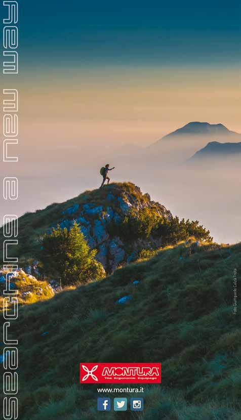
YOUR PASSION. THE RIGHT PLACE.
|
|
|
- Busso Franke
- vor 5 Jahren
- Abrufe
Transkript


1 YOUR PASSION. THE RIGHT PLACE.

2 2 TREKKING Garda Trentino, wandering from lake to sky

3 3 MONTE BALDO

4 4 Tenno Ledro Riva del Garda BIKE TREKKING CLIMBING SAILING & WINDSURFING DIVING


5 5 Palestra a cielo aperto Fitness-Studio unter freiem Himmel Outdoor training ground Dro Drena Arco Torbole sul Garda Nago CANYONING KITESURFING SWIMMING CANOE-KAYAK

6 6
7 7 Rifugi Berghütte I Alpine huts CAPANNA GRASSI Loc. Malga Grassi, Riva del Garda Tel Cell carlogrottolo@hotmail.it DAMIANO CHIESA Monte Altissimo di Nago, Brentonico Tel MALGA SAN GIOVANNI Loc. San Giovanni al Monte, Arco Tel Cell info@malgasangiovanni.com 5 PROSPERO MARCHETTI ESTATE 2017 CHIUSO Sommer 2017 geschlossen/summer 2017 closed Loc. Monte Stivo, Arco Tel NINO PERNICI Bocca Trat, Alpi di Ledro, Riva del Garda Tel Cell rifugiopernici@hotmail.it 30 SAN PIETRO Monte Calino, Tenno Tel Cell: info@rifugiosanpietro.eu 18 AL FAGGIO Loc. Al Faggio, Ledro Tel Fax info@hotelalfaggio.com 35 RIFUGIO GARIBALDI Via Strada per Tremalzo, Tremalzo Tel: GARDA Via Strada per Tremalzo, Tremalzo Tel info@tremalzo.info 13
8 8 MOUNTAIN GUIDE SERVICE BOOK IT OFFERS & ACTIVITIES ARCO MOUNTAIN GUIDE Arco Cell pag. 58 bit.ly/arcomountainguide BOOK HERE FREE ALP MOUNTAIN GUIDE SERVICE Booking & Equipment Rental: via Segantini, 86 e via Vergolano, 38 e 43 - Arco Cell Cell info@freealp.com pag. 26 bit.ly/freealp BOOK HERE GOBBI SPORT Via Segantini, 49 e 72 - Arco Tel info@gobbisport.it pag. 9 bit.ly/gobbisport BOOK HERE by Friends of Arco MMOVE INTO NATURE Via Legionari Cecoslovacchi, 14 loc. Prabi - Arco Cell Cell info@mmove.net bit.ly/friendsofarco BOOK HERE MOUNTIME OUTDOOR ADVENTURES Via P. Caproni Maini, 26e - Arco Cell info@mountime.com bit.ly/mountime BOOK HERE
 Tel.")

9 Photo credits: Fototeca Trentino Marketing, Archivio Garda Trentino SpA (Promovideo, Patrizia N. Matteotti, Daniele Lira, Mattia Bonavida), G.P. Calzà, Associazione Un territorio, due fronti, Archivio Sportler (foto di Herald Wisthaler), Archivio Consorzio per il Turismo della Valle di Ledro (Stefania Oradini, Mark Van Hattem, Promovideo). 9 Basi cartografiche riprodotte dalla CARTA ESCURSIONISTICA in scala 1: Cartografia: euroedit srl I Trento Euroedit srl Via del Commercio TRENTO (TN) Tel euroedit@euroedit.com - Stralci riprodotti per gentile concessione. Le carte sono edite e distribuite da Garda Trentino Azienda per il Turismo SpA Si declina ogni responsabilità per eventuali variazioni e inesattezze per cause non dipendenti dalla nostra volontà. Wir übernehmen keine Gewähr für eventuelle Änderungen, die unabhängig von unserem Willen sind. We do not accept any responsabilities for changes occured for reasons not dependent on our will.
10 10 Legenda Zeichenerklärung Key to symbols Dislivello Höhenunterschied Elevation difference Durata Zeit Duration Sentiero Weg Path Riferimento carta escursionistica (v. p. 40) Wanderkarte (s. S. 40) Hiking map (s. p. 40) Parcheggio Parken Parking Percorso Route Route Rifugi Berghütte Alpine huts Start Start Start Family Friendly GT GARDATREK La Corona del Garda Trentino - itinerario a tappe Die Krone des Garda Trentino - Rundweg in Etappen The crown of Garda Trentino - circular route in stages Tipologia Escursione Art der Tour Type of Tour Top 5 Grande Guerra Erster Weltkrieg First World War Interesse storico/ culturale historisch/kulturell historical/cultural Interesse naturalistico Natur nature Interesse geologico Geologie geology Sentiero della Pace Friedensweg Peace Pathway Punto Panoramico Aussichtspunkt Best view
11 11 Difficoltà Schwierigkeitsgrad Difficulty T E EE EEA SENTIERI TURISTICI: Facili itinerari, ampi, ben tracciati e con fondo stabile anche se sterrato. SPAZIERWEGE: Einfache Routen, breit, gut gekennzeichnet und auch auf Schotter mit stabilem Untergrund. TOURIST PATHS: Easy itineraries, wide, well marked, with stable roadbed even on dirt patch. SENTIERI ESCURSIONISTICI: Facili itinerari ben segnalati che tuttavia richiedono calzature e capacità di camminare anche su fondo a tratti sconnesso. WANDERWEGE: Gut ausgeschilderte, leichte Routen, die jedoch sowohl festes Schuhwerk als auch die Fähigkeit verlangen, auf teilweise unebenem Untergrund laufen zu können. HIKING PATHS: Easy and well marked routes that require, however, appropriate footwear and walking ability even on bumpy ground. SENTIERI ESCURSIONISTICI PER ESPERTI: Presentano brevi tratti attrezzati con funi e scale o ripidi ed esposti. Possono essere necessari casco e attrezzatura di autoassicurazione. Richiedono capacità di orientarsi. Prima di intraprenderli informarsi sulla percorribilità: (Commissione Sentieri). WANDERWEGE FÜR ERFAHRENE WANDERER: Kurze Streckenabschnitte mit Drahtseilen und Treppen oder steilen und ausgesetzten Passagen. Helm und Sicherheitsausrüstung können notwendig sein und man benötigt einen guten Orientierungssinn. Vor der Tour sollten Informationen über die Begehbarkeit der Strecke bei der für die Wanderwege zuständigen Kommission eingeholt werden. Infos unter: PATHS FOR EXPERIENCED HIKERS: These paths show sections equipped with ropes and ladders, and sometimes also steep and exposed parts. A helmet and a self-belay device may be necessary. These paths also require self-orientation skills. Before going, take information about the practicability of each path: (Commissione Sentieri-Office). Percorsi attrezzati in parete che richiedono specifiche attrezzature (imbragatura, set di sicurezza per ferrata, casco), conoscenze tecniche e allenamento. Prima di intraprenderli informarsi sulla percorribilità: www. sat.tn.it (Commissione Sentieri) Ausgebaute Routen an Wänden, die eine spezielle Ausrüstung (Gurt, Klettersteigset, Helm) und Erfahrung im Klettern verlangen. Vor der Tour sollten Informationen über die Begehbarkeit der Strecke bei der für die Wanderwege zuständigen Kommission eingeholt werden. Infos unter: Equipped routes on mountain walls. These routes require specific equipment (herness, safety set, helmet) and climbing skills. Before setting off, take information about the practicability of each path: (Commissione Sentieri)

12 12 GARDA TREK LA CORONA DEL GARDA TRENTINO Tre itinerari circolari da percorrere a tappe, lungo i pendii ed i crinali che fanno da corona al più grande lago d Italia. Tre percorsi di impegno crescente posti a quote diverse: i primi due da percorrere tutto l anno per scoprire i fantastici panorami che il Garda Trentino sa offrire anche nelle terse giornate invernali tra lecceti, oliveti e castelli, il terzo è una vera e propria cavalcata tra terra e cielo, lungo la cresta spartiacque che corona l Alto Garda, dalle scogliere del Garda ai pascoli di alta montagna del Monte Stivo ed Altissimo. Un tour impegnativo da percorrere in una settimana, con una successione di saliscendi da quota 90 a quota A completare il pieno di emozioni le magiche notti nei rifugi in quota, mentre giù in basso il lago riflette le luci delle piccole città sulla costa.

13 13 DIE KRONE DES GARDA TRENTINO Es gibt drei Rundwege, die in Etappen zurückgelegt werden können und längs der Hänge und Gebirgskämme verlaufen, die eine Art Krone um den größten See Italiens bilden. Die drei verschiedenen Routen bieten verschiedene Schwierigkeitsgrade in unterschiedlichen Höhenlagen: Die ersten zwei Wege sind das ganze Jahr über nutzbar. Hier können Besucher die fantastischen Panoramaaussichten zwischen Steineichen, Olivenhainen und Burgen entdecken, die das Garda Trentino auch im Winter an klaren Tagen zu bieten hat. Die dritte Route ist eine echte Abenteurertour entlang der Bergkämme, die den oberen Gardasee krönen und zwischen denen eine Wasserschneise verläuft. Sie führt über die Klippen des Gardasees bis zu den Almen des Hochgebirges von Monte Stivo und Altissimo. Eine anspruchsvolle Tour mit Höhenunterschieden von 90mt bis auf 2100mt. Für diese Tour sollte eine Woche eingeplant werden. Die perfekte Ergänzung der Wanderrouten ist eine Übernachtung in den Schutzhütten hoch oben in den Bergen. Besucher erleben den nächtlichen Sternenhimmel in den Bergen, während sich im See weiter unten die Lichter der kleinen Küstenorte widerspiegeln.

14 14 THE CROWN OF GARDA TRENTINO Three circular routes that are divided in stages, along the slopes and ridges that form the crown of Italy s largest lake. The three paths of varying degrees of difficulty are located at different hights. The first two routes can be walked throughout the entire year, to discover the breathtaking views that the Garda Trentino can offer during the clear winter days, among holm oak, olive groves and castles. The third route is a real journey between land and sky along the watershed ridge that crowns the Alto Garda, from the cliffs of the lake to the mountain pasture land of Mount Stivo and Altissimo. A demanding tour of approximately one week, with a succession of ups and downs that goes from 90mt to 2100mt altitude difference. All the emotions experienced will be crowned by the quiet magical nights spent in the mountain huts, enjoying the spectacular view of the lake at night, reflecting the lights of the coastal towns.

15 15 N.Pernici Cap. Grassi Tenno S.Pietro Riva del Garda S. Giovanni Dro Arco Torbole sul Garda Nago Drena D. Chiesa Altissimo P. Marchetti

16 16 LOW LO P CORONA BASSA Tappe / Etappen/ Stages: m 1045 m 33,50 km tot. 1. RIVA DEL GARDA - ARCO 540 m 520 m 14 km h 5,00 Riva del Garda (65 m) - Bastione (211 m) - Maddalena (270) - Foci-San Giacomo (155 m) - Deva (265 m) - San Lorenzo (330 m) - Tenno (406 m) - Novino (445 m ) - Valle del Tovo ( 490) - Falesia Baone (161 m) - Fontanelle - Arco (90 m) 2. ARCO - RIVA DEL GARDA 505 m 525 m 19,50 km h 6,00 Arco (90 m) - loc. Moletta (90 m) - Vastrè (300 m) - San Martino (120 m) - Massone (116 m) - Bolognano (145 m) - Vignole (125 m) - Belvedere Marmitte dei Giganti (165 m) - Nago (215 m) - Castel Penede (270 m) - Strada Santa Lucia - Torbole (66 m) - Riva del Garda
17 17 MEDIUM LO P CORONA MEDIA Tappe / Etappen/ Stages: m 3275 m 73,20 km tot. 1. RIVA DEL GARDA - RIFUGIO SAN PIETRO 1285 m 375 m 17,70 km h 6,00 Riva del Garda (65 m) - SAT Campi (692 m) - San Martino (789 m) - Pranzo (508 m) - Ville del Monte ( q 535), Canale ( q 585), Lago di Tenno/ Tennosee/lake Tenno ( q 600), SAT 406, SAT 406A ( q 683), SAT 406A, Bastiani ( q 854), SAT 406, Rif. San Pietro ( q 976) 2. RIFUGIO SAN PIETRO - CENIGA 380 m 1245 m 13 km h 4,00 Rif. San Pietro (976 m) - SAT Vedesè (970 m ) - Treni (835 m) - Croce di Bondiga (855 m) - SAT Bocca di Tovo (1079 m) - SAT Mandrea (620 m) - SAT SAT Ponte romano/römische Brücke/Roman bridge - Ceniga (108 m) 3. CENIGA - BOLOGNANO 710 m 675 m 19,50 km h 6,5 Ceniga (108 m) - Drena (390 m) - Open Air Gallery (460 m) - Braila (530 m) - Carobbi (750 m) - Troiana (660 m) - Pratacca - Bolognano (144 m) 4. BOLOGNANO - RIVA DEL GARDA 900 m 980 m 23 km h 7,00 Bolognano (144 m) - Busa dei Capitani (480 m) - Nago (200 m) - SAT Malga Zures (690 m) - Varno (590 m) - Busatte - Tempesta (227 m) - Torbole (67 m) - Riva del Garda (65 m) Descrizione dettagliata di ogni tappa, mappa e traccia gpx a disposizione sul nostro sito. Eine ausführliche Beschreibung zu jeder Etappe, Karten und GPX-Tracks finden Sie auf unserer Website. Go to our website for a detailed description, map, and gpx track for each stage.
18 18 TOP LO P CORONA ALTA Tappe / Etappen/ Stages: m 5305 m 90 km tot. 1. RIVA DEL GARDA - RIFUGIO NINO PERNICI 1800 m 280 m 12,50 km h 7,00 Riva del Garda (65 m) - SAT SAT SAT Bocca Giumella (1410 m) - SAT Bocca Saval (1740 m) - Rif. Nino Pernici (1600 m) 2. RIFUGIO NINO PERNICI - RIFUGIO SAN PIETRO 390 m 1000 m 11 km h 3,50 Rif. Nino Pernici (1600 m) - Bocca di Trat (1582 m) - Sentiero della Regina SAT Monte Vender (1504 m) - Lago di Tenno/Tennosee/lake Tenno (600 m) - SAT Canale di Tenno - SAT Bastiani (854 m) - SAT Rif. San Pietro (976 m) 3. RIFUGIO SAN PIETRO - CENIGA 720 m 1575 m 18,50 km h 5,5 Rif. S. Pietro (976 m) - SAT Monte Calino (1069 m) - Treni (835 m) - Croce di Bondiga (855 m) - SAT Bocca di Tovo (1079 m) - SAT 407A - Monte Biaina (1413 m) - San Giovanni al Monte (1060 m) - SAT Dos del Clef (720 m) - Mandrea (620 m) - SAT SAT Ponte romano/ römische Brücke/Roman bridge - Ceniga (108 m) 4. CENIGA - RIFUGIO PROSPERO MARCHETTI 1900 m 15,30 km h 7,50 Ceniga (108 m) - Coste di Varino - Sentiero della Maestra SAT Braila (530 m) - SAT Malga Vallestrè (1455 m) - SAT Monte Stivo (2058 m) - Rif. Prospero Marchetti (2012 m - CHIUSO/GESCHLOSSEN/CLOSED ESTATE/SOMMER/SUMMER 2017) 5. RIFUGIO PROSPERO MARCHETTI - NAGO 1800 m 12,50 km h 3,50 Rif. Prospero Marchetti (2012 m) - SAT Le Prese (1458 m) - Malga Zanga (1142 m) - Malga Fiavei (910 m) - SAT Tre Croci (438 m) - Castagneto/ Kastanienhain/Chestnut grove - Nago (215 m)
 - Rif. Damiano Chiesa (2060 m) 7. RIFUGIO DAMIANO CHIESA - RIVA DEL GARDA (VIA BATTELLO/ MIT DEM BOOT /BY BOAT) 330 m 650 m 7 km h 2,5 Rif.")
 Descrizione dettagliata di ogni tappa, mappa e traccia gpx a disposizione sul nostro sito. Eine ausführliche Beschreibung zu jeder Etappe, Karten und GPX-Tracks finden Sie auf unserer Website.")
19 19 6. NAGO - RIFUGIO DAMIANO CHIESA 1850 m 11 km h 7,00 Nago (215 m) - San Giuseppe (230 m) - SAT Malga Zures (690 m) - Malga Casina (1045 m) - Monte Varagna - SAT Monte Altissimo (2079 m) - Rif. Damiano Chiesa (2060 m) 7. RIFUGIO DAMIANO CHIESA - RIVA DEL GARDA (VIA BATTELLO/ MIT DEM BOOT /BY BOAT) 330 m 650 m 7 km h 2,5 Rif. Damiano Chiesa (2060 m) - SAT Bocca di Navene (1422 m) - SAT Colma di Malcesine (1754 m) - Funivia/Seilbahn/Cable way Malcesine - Monte Baldo (1730 m) - Malcesine (89 m) - Riva del Garda (65 m) Descrizione dettagliata di ogni tappa, mappa e traccia gpx a disposizione sul nostro sito. Eine ausführliche Beschreibung zu jeder Etappe, Karten und GPX-Tracks finden Sie auf unserer Website. Go to our website for a detailed description, map, and gpx track for each stage.
20 20 1. Sentiero della Ponale RIVA DEL GARDA - BIACESA 1 h. 2.30/3 fino a Pregasina nach Pregasina to Pregasina mt. 450 (Pregasina) mt. 600 (Lago di Ledro) E Attenzione! Alcuni tratti esposti alla caduta massi Achtung! Teilweise Steinschlaggefahr Attention! Partly exposed to falling rocks Via Monte Oro Biacesa DESCRIZIONE/BESCHREIBUNG/DESCRIPTION Dalla Centrale Idroelettrica di Riva del Garda, dirigersi in direzione sud, fino a trovare sulla destra, prima del tunnel, l inizio del sentiero. L itinerario si snoda a picco sulle acque del lago e regala panorami mozzafiato a ogni curva. Raggiunto il ponte che scavalca la Valle del Ponale si può decidere se salire a destra per raggiungere il Lago di Ledro o salire a sinistra per raggiungere l abitato di Pregasina. (Possibile rientro con i mezzi pubblici al bivio con la SS 240, a 3 km da Pregasina). Vom Wasserkraftwerk in Riva del Garda geht man in Richtung Süden bis zum Beginn des Weges auf der rechten Seite vor einem Tunnel. Die Route schlängelt sich oberhalb des Gardasees entlang und bietet bei jeder Kurve atemberaubende Ausblicke.Bei der Brücke über dem Ponaletal können Besucher entscheiden, ob sie rechts zum Ledrosee oder links zum Dörfchen Pregasina gehen möchten. Die Rückkehr ist mit öffentlichen Verkehrsmitteln von der Kreuzung an der Hauptstraße 240 möglich, ca. 3 km von Pregasina entfernt. Head south from the Riva del Garda Hydroelectric Power Station until you come to the start of the path on your right before the tunnel. This trail winds along the lake overlooking the water, with amazing views around every bend. When you get to the bridge across the Ponale Valley you can decide whether to go up on the right to Lake Ledro or go down on the left to Pregasina (Possible return to Riva del Garda with public transport at the junction with the main road 240, 3 Km from Pregasina). La Ponale è raggiungibile anche da Biacesa. Si percorre il sentiero all imbocco della strada che porta verso Pregasina, passando per i ruderi dell ex-centrale elettr. Rovereto, sino a raggiungere la Strada della Ponale. Voltando a destra si sale ancora e si può raggiungere Pregasina, mentre a sinistra si scende verso Riva del Garda. Die Ponale ist auch von Biacesa aus erreichbar. Nehmen Sie den Weg an der Einmündung der Straße, die nach Pregasina führt, vorbei an den Überresten des einstigen Wasserkraftwerks Rovereto, bis Sie die Strada della Ponale erreichen. Rechts geht es nach Pregasina hinauf, links hingegen hinab nach Riva del Garda. You can also get to the Ponale from Biacesa. Follow the trail at the start of the road to Pregasina which takes you past the ruins of the old Rovereto power station until you get to the Ponale Road. Turn right and it takes you further up to Pregasina, but if you turn left you head back down to Riva del Garda.


21 La strada del Ponale era un tempo l unica via di comunicazione tra il Garda Trentino e la Valle di Ledro. Inaugurata nel 1851, è rimasta aperta al traffico fino al Die Ponalestraße war einmal die einzige Verbindung zwischen Garda Trentino und dem Ledrotal eröffnet, war die Straße für den Verkehr bis 1992 freigegeben. The Ponale road was once the only route between Garda Trentino and Ledro Valley. It was inaugurated in 1851 and stayed open to public trafic up to Nella foto Autobus Fiat 621 RN da 22 posti del Collezione R. Trenti. Immagine tratta da A picco sul lago. Ponal - Uno spettacolo in roccia - Associazione Riccardo Pinter, GPS download:
22 Sentiero Busatte-Tempesta TORBOLE SUL GARDA 20 T h. 1.30/2 andata Hinweg one way to Tempesta Parco delle Busatte (Torbole) mt. 220 DESCRIZIONE/BESCHREIBUNG/DESCRIPTION Dal parco delle Busatte inizia la spettacolare escursione che si snoda per 4 km, con scalinate di ferro di quasi 400 gradini, quasi un balcone sul Lago di Garda. Il percorso è semi pianeggiante e supera due costoni: Corno di Bò e Salt de la Cavra. In un ora e mezza circa, attraversando paesaggi incantevoli, a strapiombo sul lago, caratterizzati da aspetti geologici, floreali e naturalistici straordinari, si raggiunge Tempesta (rientro con mezzi pubblici). In alternativa, al bivio con la strada forestale che scende a Tempesta, è possibile risalire e ricongiungersi al sentiero Busatte-Tempesta nei pressi della prima scalinata. Vom Park Busatte aus beginnt die herrliche Wanderung auf dem Naturpfad Busatte- Tempesta, der mit seiner Länge von 4 km wie eine Aussichtsplattform über dem See zu schweben scheint und Eisentreppen mit fast 400 Stufen einschließt. Die Strecke verläuft ziemlich eben und überwindet zwei Gebiete: Corno di Bò und Salt de la Cavra. Man durchquert eine zauberhafte Landschaft hoch über dem See und erreicht in etwa eineinhalb Stunden die Ortschaft Tempesta. Am Ziel angelangt, kommt man mit dem Bus der Linie A.P.T.V. nach Torbole zurück. Es ist auch möglich, zu Fuß nach Torbole zurück zu gehen. An der Kreuzung, an welcher die Forststraße runter nach Tempesta führt, begibt man sich einfach wieder auf den Weg nach oben, bis man den Busatte-Tempesta Weg in der Nähe der ersten Treppe erreicht. From Park Busatte s grassy area you head off for a spectacular hike along the Busatte Tempesta trail, a nature route overhanging the lake which winds for 4 km and includes flights of metal stairs with a total of 400 steps. The route is mostly flat and it has two climbs: Corno di Bò and Salt de la Cavra. This 90 minute hike through wonderful scenery, right above the lake in the midst of nature, flowers and geological phenomena, leads you to Tempesta. From here the trip back to Torbole can be made aboard a bus of the A.P.T.V. line. It is also possible to walk back to Torbole: at the junction with the road leading down to Tempesta, just go up the road till you reach again the Busatte - Tempesta path near the first stairs.


23 GPS download: 23
24 Marocche - Le Valli della Luna Das Mondtal/The lunar valley DRO 14 E h. 2/2.30 itinerario circolare Rundweg loop mt. 100 Nei pressi del tiro a piattello In der Nähe der Tontaubenschießen-Anlage Near the clay pigeon shooting area DESCRIZIONE/BESCHREIBUNG/DESCRIPTION Il biotopo delle Marocche è un deposito di materiale roccioso formato dal fenomeno delle glaciazioni. Sulla strada verso Drena, gli ingressi sono sulla sinistra, nei pressi dei parcheggi di fronte al tamburello. L ambiente ricorda un paesaggio lunare, a tratti desertico; dall ammasso roccioso si raggiunge la zona dove sono state scoperte impronte di dinosauri. Si attraversa il bosco verso il fiume Sarca e si costeggia l oasi paludosa dei Laghissol. Das Biotop Marocche ist eine ungeordnete Anhäufung an Lockergestein, die durch einen mit der Vergletscherung zusammenhängenden Erdrutsch entstanden ist. Auf der Straße nach Drena sind die Eingänge links neben den Parkplätzen ausgeschildert. Die Umgebung erinnert an eine teils wüstenartige Mondlandschaft. In dem Gebiet sind erst kürzlich Abdrücke von Dinosauriern aus dem Jura-Zeitalter entdeckt worden. Der Weg zum Mondtal führt durch den Wald zum Fluß Sarca und dann entlang des Sumpfgebietes von Laghissol. The Marocche biotope is a huge accumulation of rocky material created in the post-glacial period. The entry points are on the road to Drena, on your left, near the parking places. The landscape reminds of a lunar and sometimes even desert setting. From the great pile of rocks the path leads to the area where dinosaur tracks were discovered. It goes on in the wood towards river Sarca and then along the edge of the marshy Laghissol area. GIOCHIAMO ALL ESPLORATORE? Scopri le orme di dinosauro nascoste tra i massi delle Marocche: sono state lasciate ben 190 milioni di anni fa, che emozione toccarle! LUST AUF EINE EXPEDITION? Entdecke die Dinosaurier- Fußabdrücke in der Marocche: Diese wurden hier vor etwa Jahren hinterlassen. Was für ein Nervenkitzel, sie zu berühren! LET S PLAY THE EXPLORER! Find the dinosaurs footprints hidden in the Marocche: they were left more years ago, what a thrill to touch them!


25 GPS download: 25

26 26 Rif. San Pietro Monte Calino TENNO sentiero CAI/SAT 401/409 E h. 2/3 itinerario circolare Rundweg loop mt. 600 Parcheggio municipio Tenno Rathausparkplazt Tenno Town Hall parking place Tenno Rifugio San Pietro DESCRIZIONE/BESCHREIBUNG/DESCRIPTION Al bivio con la statale imboccare il sentiero SAT 401, fino a Calvola e poi a loc. La Croce. Su strada asfaltata proseguire fino a loc. Ranciom (percorso Mountain&Garda Bike) e loc. Treni. Imboccare il sentiero SAT 401 (Frassati) verso il Monte Calino in direzione sud. Dalla cima, scendere al rif. San Pietro. Um zur Berghütte San Pietro zu kommen, nimmt man von Tenno kommend den Weg SAT 401 nach Calvola und von dort aus weiter bis La Croce. Über eine asphaltierte Straße geht man weiter bis Ranciom (Mountain & Garda Bike Strecke) und Treni. Dort folgt man den Weg SAT 401 (Frassati) zum Monte Calino Richtung Süden. At the junction with the main road take the path SAT 401 to Calvola and La Croce. Go ahead on the asphalt road to Ranciom (Mountain & Garda Bike trail) and to Treni. Take then the path SAT 401 (Frassati) to Monte Calino heading southward. Form the top, go downhill to Rifugio San Pietro.


27 GPS download: 27
28 I Forti del Monte Brione RIVA DEL GARDA 21 T h. 3 itinerario circolare Rundweg loop Porto San Nicolò mt. 350 DESCRIZIONE/BESCHREIBUNG/DESCRIPTION L itinerario lungo il sentiero della Pace, tocca vari forti della Festung Abschnitt: visibili i resti di camminamenti, osservatori, trincee e strade militari. Il Monte Brione è un Biotopo: si contano ca. 500 specie diverse di piante, tipicamente mediterranee. Die Route zur Festung I Forti del Monte Brione führt den Friedenspfad entlang, wo man auf verschiedene Stationen des Festungsabschnittes trifft: Überreste von Laufgräben, Beobachtungsständen, Schützengräben und Militärstraßen sind hier sichtbar. Die Gegend Monte Brione ist zudem ein Naturreservat: Hier gibt es über 500 verschiedene Pflanzenarten einer typischen mediterranen Vegetation. The itinerary proceeds along the Peace Path, touching different forts: visible remains of the communication trenches, observation posts, combat trenches and military roads. Monte Brione is a protected natural area: you can find here more than 500 different species of a typical mediterranean vegetation. L Impero austroungarico eresse delle opere a guardia della riva nord del lago: il Festung Abschnitt, il settore fortificato di Riva del Garda. Al centro dell opera il Monte Brione con il Forte San Nicolò ( ) verso il lago, il forte S. Alessandro (1881) vicino alla cima, il Forte Batteria di Mezzo (1900) e il Forte Garda (1907). Die österreichisch-ungarische Monarchie errichtete ein Netz von Festungswerken zum Schutz des nördlichen Gardaseeufers: Der Festungsabschnitt von Riva del Garda. In der Mitte des Befestigungssystems stand der Monte Brione mit dem Forte San Nicolò ( ) an der Seeseite, dem Forte S. Alessandro (1881) auf der Spitze, und dazwischen der Befestigung Batteria di Mezzo (1900) sowie dem Forte Garda (1907). The Austo-Hungarian Empire built a serie of forts to protect the northern shore of lake Garda: the Festung Abschnitt. In the middle of the system was Monte Brione with its Forte San Nicolò ( ) close to the lake, the Forte S. Alessandro (1881) on the top, the Forte Batteria di Mezzo (1900) and the Forte Garda (1907).


29 29 GPS download: 29


30 30 Bastione Santa Barbara RIVA DEL GARDA Sentiero CAI/SAT 404 E h. 1.30/2 andata Hinweg uphill Via Monte Oro - Riva del Garda mt. 550 DESCRIZIONE/BESCHREIBUNG/DESCRIPTION Dal parcheggio salire al Bastione e proseguire sul sentiero SAT 404 direzione Capanna Santa Barbara. Da qui si raggiunge in breve l omonima chiesetta. Vom Parkplatz aus steigt man zur Bastione hinauf und geht dann weiter über den Weg SAT 404 Richtung Capanna Santa Barbara. Von hier erreicht man in kurzer Zeit die kleine Kirche. Form the parking place go up to the Bastione and then continue on the path SAT 404 to Capanna Santa Barbara. The chapel is shortly after the hut. GPS download:

31 31 Bastione - Santa Maria Maddalena - Foci San Giacomo RIVA DEL GARDA Sentiero CAI/SAT 404 E 1.30 Itinerario circolare Rundweg loop Via Monte Oro - Riva del Garda mt. 200 DESCRIZIONE/BESCHREIBUNG/DESCRIPTION Dal parcheggio salire in direzione Bastione per strada lastricata, indicazioni sentiero SAT 404. A quota 245 si raggiunge un bivio, a sinistra si raggiunge il Bastione - torrione fortificato del XVI secolo. Ritornare al bivio e seguire la strada sterrata - indicazioni per Campi/Rif. Pernici. Dopo 600 m si raggiunge il bivio per Foci/San Giacomo. Dopo 100 m si raggiunge la chiesa di Santa Maria Maddalena ( 1200 DC). Si prosegue in piano fino ad uno spiazzo con bacheca, da cui si scende lungo un tratto gradinato fino alla loc. Foci/San Giacomo, da cui si rientra a Riva del Garda lungo Via Ardaro. Vom Parkplatz folgt man dem gepflasterten Weg (SAT 404) Richtung Bastione. Auf einer Höhe von 245m erreicht man eine Gabelung. Links erreicht man die Bastion (befestigter Wachturm des 16. Jahrhunderts). Kehren sie zurück zur Gabelung und folgen sie der Schotterstrasse. Hinweisschilder für Campi/Rif. Pernici. Nach 600m erreichen sie die Kreuzung nach Foci/San Giacomo. Nach weiteren 100m gelangt man zur Kirche Santa Maria Maddalena (1200 AD). Am höchsten Punkt gibt es einen freien Platz mit Schaukasten, von welchem man über einen stufenförmigen Weg bis zur Loc. Foci/san Giacomo absteigt. Von hier folgt man Via Ardaro zurück bis nach Riva del Garda. From the parking lot you follow the dirt road (SAT 404) in direction to Bastione. At a height of 245m you reach an intersection. Going to the left you reach the bastion (fortificated tower, XVI century). Return to the intersection and follow the path with indication to Campi/Rif. Pernici. After 600m you reach the intersection Foci/San Giacomo. After another 100m you have reached the church of Santa Maria Maddalena (1200 AD). At the highest point you find a space with a showcase, from which you descend on a stepped path to Loc. Foci/san Giacomo. From here you proceed on Via Ardaro back to Riva del Garda. GPS download:

32 Marmitte dei Giganti Castagneto - Perlone TORBOLE SUL GARDA - NAGO 18 h. 2/2.30 andata Hinweg uphill itinerario circolare Rundweg loop E mt. 400 Torbole DESCRIZIONE/BESCHREIBUNG/DESCRIPTION Dalla fine di via Strada Granda salire fino ai pozzi glaciali Marmitte dei Giganti. Attraversare la statale e proseguire verso Nago. Alla rotonda, attraversare la strada e a sinistra lungo il sentiero del Castagneto risalire il Monte Perlone. Am Ende der Strada Granda kann man zu den Marmitte dei Giganti, auf Deutsch Töpfe der Riesen, hinauf steigen. Dabei handelt es sich um Eislöscher, auch Gletschermühlen genannt, die in der Eiszeit entstanden sind. Man überquert die Hauptstraße und geht weiter bis nach Nago; am Kreisverkehr überquert man noch einmal die Hauptstraße und nimmt links den Weg del Castagneto zum Monte Perlone hinauf. At the end of via Strada Granda go up to the glacial potholes Marmitte dei Giganti. Cross the main road and walk on up to Nago. At the turnabout cross the road and take the path del Castegneto on the left, which leads up to Monte Perlone. GPS download:


33 33 7. Bosco Caproni e Trincee di Vastrè ARCO 7 E h. 2 itinerario circolare Rundweg loop Carmellini al Ponte - Arco mt. 200 DESCRIZIONE/BESCHREIBUNG/DESCRIPTION Seguire la ciclabile fino a loc. Moletta, attraversare la statale e, passando dalla chiesetta di San Martino, proseguire per loc. Troiana. Al primo tornante, sulla mulattiera a sinistra, salire fino al bivio per il sentiero SAT 667, da qui a sinistra per il percorso delle Trincee. Dopo 300 metri, tornare sul sentiero principale e, verso destra, alla chiesetta di San Martino. Dieser historische Naturlehrpfad und Steinbruch liegt oberhalb (nordöstlich) des Ortsteiles Masone von Arco. Man folgt dem Radweg bis loc. Moletta, überquert dann die Hauptstraße und geht an der Kirche San Martino vorbei, weiter Richtung Troiana. In der Nähe der ersten Kehre kommt man links an eine Kreuzung, von der der Weg SAT 667 abgeht: Hier läuft man links entlang des ehemaligen Schützengrabens. Nach 300 Metern kehrt man zum Hauptweg zurück und biegt rechts zur Kirche San Martino ein. Follow the cycle path to loc. Moletta, cross the main road and, passing by the little church of San Martino, go ahead to Troiana. At the first bend take the track on the left till the junction with path SAT 667 and keep left for the Trench trail. After 300 m go back on the main path and, on the right, head back to the church of San Martino. GPS download:

34 34 6. Castello - Monte Colodri Monte Colt ARCO 6 h. 3 itinerario circolare Rundweg loop mt. 330 EE Escursionisti esperti, attenzione tratti esposti e ripidi - fondo sconnesso e con roccette Erfahrene Wanderer. Achtung: Ausgesetzte und steile Stellen, sowie loser und steiniger Untergrund Expert trekkers, warning: steep exposed stretches - rough stony terrain underfoot Arco DESCRIZIONE/BESCHREIBUNG/DESCRIPTION Dal centro di Arco, salire verso il castello, deviando poco prima dell ingresso per la valletta di Laghel, fino alla chiesetta di Santa Maria. A destra lungo il Sentiero dei Lecci fino al Monte Colodri, poi su sentiero SAT 431 lungo la cresta raggiungere la cima del Monte Colt. Su tratti ripidi ed esposti fino alla Croce di Colt, da qui scendere al Ponte Romano di Ceniga. Rientro in 50 minuti ad Arco. Vom Stadtzentrum Arco aus steigt man zur Burg hinauf. Kurz vor dem Eingang führt ein Wanderweg zum Laghel bis zur Kirche Santa Maria. Von dort aus geht man rechts über den Sentiero dei Lecci zum Monte Colodri, dann über den Weg SAT 431 den Kamm entlang bis zum Gipfel des Monte Colt. Bis zum Gipfelkreuz des Colt gibt es steile und unbefestigte Stellen. Von dort führt der Weg zur römischen Brücke in Cenica. Der Rückweg nach Arco dauert ca. 50 Minuten. From the centre, walk up to the castle. Before the entry, take the path to Laghel, till the little church of Santa Maria. Stay on the right on the Sentiero dei Lecci till Monte Colodri, then take path SAT 431 and, along the ridge, reach the top of Monte Colt. Across some steep exposed sections of the path go on till the Cross of Colt: from there, go downhill till the Roman Bridge in Ceniga. Form there you are back in Arco in 50 minutes. GPS download:
 Höhenweg (mt. 2079) High altitude route (mt. 2079) Prati di Nago (mt. 1560) Rifugio Di.")
35 35 Prati di Nago Monte Altissimo NAGO Sentiero CAI/SAT 601 h.3 andata Hinweg uphill mt. 550 E Non presenta difficoltà tecniche ma richiede abbigliamento adatto alla quota (si raggiungono mt. 2079) Höhenweg (mt. 2079) High altitude route (mt. 2079) Prati di Nago (mt. 1560) Rifugio Di. Chiesa - Altissimo DESCRIZIONE/BESCHREIBUNG/DESCRIPTION Dal parcheggio raggiungere il Monte Varagna con il sentiero SAT 601 e, lungo la cresta nord, la cima del Monte Altissimo fino al rifugio Damiano Chiesa. Presenza di trincee e fortificazioni. Vom Parkplatz aus erreicht man auf dieser Wanderroute zuerst den Monte Varagna über den Weg SAT 601. Dann geht es den Kamm entlang zum Gipfel des Monte Altissimo bis zur Berghütte Damiano Chiesa. Auf dem Weg kann man viele ehemalige Schützengräben und Befestigungsanlagen sehen. From the parking place reach first the Monte Varagna following the path SAT 601 and then, along the ridge, the top of Monte Altissimo and the Rifugio Damiano Chiesa. Many trenches and fortifications. GPS download:


36 36 Monte Stivo ARCO Sentiero CAI/SAT 608B h. 3 andata Hinweg uphill mt. 800 Rifugio P. Marchetti E Itinerario in quota (mt. 2058) Höhenweg (mt. 2058) High altitude route (mt. 2058) Da Loc. Santa Barbara sul Monte Velo raggiungere il parcheggio a S. Antonio Von Santa Barbara auf dem Monte Velo erreicht man den Parkplatz in S. Antonio From Santa Barbara on Monte Velo reach the parking place in S. Antonio DESCRIZIONE/BESCHREIBUNG/DESCRIPTION Dal parcheggio seguire le indicazioni SAT 608B fino a loc. Prese. Poi, sul sentiero SAT 608, raggiungere Malga Stivo e, con un tratto ripido, il Rifugio Marchetti e la cima. Der Aufstieg zum Monte Stivo erfolgt über Forstwege und eine schmale Steige vom Passo Bordala aus. Über den Kamm erreicht man den Nordosten des Gipfels und hat aufgrund der herausragenden Lage des Monte Stivo einen herrlichen Blick auf die umliegenden Gebirgsgruppen. Vom Parkplatz aus kann man den Weg SAT 608B bis Prese folgen. Dort nimmt man den Weg SAT 608 zur Malga Stivo und erreicht über eine steile Strecke die Berghütte Marchetti und den Gipfel. From the parking place follow the signpost SAT 608B till Prese, From there go ahead on the path SAT 608 to Malga Stivo and, on a steep trail, reach Rifugio Marchetti and the top. GPS download:


37 37 Monte Misone TENNO Sentiero CAI/SAT 406/412 E h 2.30 andata Hinweg uphill Loc. Calino 753 m DESCRIZIONE/BESCHREIBUNG/DESCRIPTION Dal parcheggio, imboccare la strada forestale in direzione Monte Misone, quindi il sentiero SAT 412 che sale ripido fino alla Sella del Castiol. Si prosegue fino alla Malga Misone e di qui, in circa 40 minuti, alla cima. Vom Parkplatz aus nimmt man die Waldstraße Richtung Monte Misone und dann den Weg SAT 422. Dieser führt steil hinauf bis Sella del Castiol. Weiter geht es bis zur Alm Malga Misone. Von dort erreicht man in etwa 40 Minuten den Gipfel. From the parking place take the forest road in direction Monte Misone and then path SAT 422 which climbs up steep to Sella del Castiol. Go on till Malga Misone and, from here, reach in about 40 min. the summit. GPS download:

38 Narveol - Salim DRENA 17 E 1,30/2,00 Drena centro 150 m DESCRIZIONE/BESCHREIBUNG/DESCRIPTION Dal centro di Drena salire lungo la strada selciata parallela all ingresso del Santuario di Fatima. Poco prima di una netta curva prendere a destra un sentiero che in breve porta a loc. Narveol. Si costeggia - lasciandola a sinistra - un abitazione rurale e si prosegue tra due muri in pietra. Al termine si prende a sinistra la traccia in salita e si raggiunge Maso Salim costeggiando un muraglione in pietra. Rientro al punto di partenza seguendo la strada sterrata e poi asfaltata, si attraversa la zona artigianale di Drena. Die Route zum Ort Narveol führt vom Ortskern Drena die gepflasterte Straße hinauf, die sich parallel zum Eingang der kleinen Gedenkkapelle von Fatima befindet. Vor einer scharfen Kurve führt ein Weg rechts ab, der in kurzer Zeit zum Ort Narveol führt. Auf dem Weg zur Ferienwohnung Maso Salim kommt man an einem Bauernhof vorbei, der sich auf der linken Seite befindet und setzt den Weg dann zwischen zwei Steinmauern fort. Am Ende nimmt man auf der linken Seite einen Pfad bergauf entlang einer Steinmauer und erreicht dann Maso Salim. Die Rückkehr zum Ausgangspunkt erfolgt zuerst über Schotterstraße und dann über Asphalt. Man durchquert dabei das Gewerbegebiet von Drena. From the center of Drena you go up the causeway parallel to the entrance of the Fatima Sanctuary. Just before a sharp curve take the path on the right, which takes you quickly to Loc. Narveol. On your left there is a rural house, you follow the path between two stone walls. At the end you take the left path going up to Maso Salim alongside a stone wall. Go back to the starting point by taking first the stoney road and then continuing on the paved road to the industrial area of Drena. GPS download:

39 39 San Giovanni - Monte Brento ARCO 408/408B EE 4 h itinerario circolare Rundweg loop Malga San Giovanni 504 m DESCRIZIONE/BESCHREIBUNG/DESCRIPTION Dal parcheggio, imboccare il sentiero SAT 408 fino a Malga Valbona, quindi proseguire sul sentiero SAT 408B in direzione Monte Brento. Attenzione! In questo tratto il sentiero è piuttosto esposto ma offre una vista spettacolare sulla Valle del Sarca. Dalla cima, tenere il sentiero SAT 408B fino al punto di partenza. Vom Parkplatz aus nimmt man den Weg SAT 408 bis Malga (Alm) Valbona, dann geht man weiter über den Weg SAT 408B in Richtung Monte Brento. Achtung! Der Weg ist hier ausgesetzt, aber bietet einmalige Blicke über das Sarcatal. Vom Gipfel kehrt man über den Weg SAT 408B zum Startpunkt zurück. From the parking place take path SAT 408 until Malga Valbona, then go further on the path SAT 408B towards Monte Brento. Attention! The trail is exposed here but offers a unique view over the Sarca Valley. From the summit, take path SAT 408B back to the starting point. GPS download:

40 40 Garda Trentino & Valle di Ledro Trekking Maps IT Scopri tutti gli itinerari Trekking del Garda Trentino e della Valle di Ledro! Più di 800 km sui più bei percorsi dell alto Garda, Valle di Ledro e non solo, itinerari che dalle rive del lago arrivano sino a mt. Ce n è per tutti i gusti: escursioni facili, sentieri lungo i percorsi della Guerra, trekking impegnativi a tappe e ferrate con viste panoramiche... vivi la tua passione: CAMMINA NEL GARDA TRENTINO E NELLA VALLE DI LEDRO! In vendita presso tutti gli uffici informazioni Garda Trentino e Ledro. Entdecken Sie mit uns alle Wanderrouten des Garda Trentino und Ledrotals! Mehr als 800 km auf den schönsten Strecken des nördlichen Gardasees und Ledrosees, vom Seestrand bis zu 2000Mt Höhe - und das ist noch nicht alles. Im Garda Trentino und Ledrotal gibt es Wanderwege für jeden Geschmack: Einfache Spaziergänge, historische Pfade entlang der ehemaligen Front des Ersten Weltkrieges, anspruchsvolle Wanderungen in Etappen und Klettersteige mit einmaligem Ausblick. Erleben Sie Ihr ganz persönliches Abenteuer: WANDERN SIE IM GARDA TRENTINO UND LEDROTAL! Die Garda Trentino Trekking Map erhalten Sie in den Informationsbüros von Garda Trentino und Ledro. DE EN Discover all the hiking routes of Garda Trentino and Ledro Valley! More than 800 km on the most beautiful itineraries of Garda Trentino and Ledro Valley, going from the lake up to 2000 mt high. We have all you ever wished for: easy walks, paths along the former front line of the WWI, challenging trekking in stages and via ferrata with stunning views. Live your passion, walk on in the Garda Trentino and Ledro Valley! On sale at Garda Trentino and Ledro tourist offices.
41 41

42 42 Grande Guerra: tracce sul fronte meridionale Der Erste Weltkrieg: Spuren entlang der Südfront The Great War: Traces on the southern front IT Il Garda Trentino e la Valle di Ledro si trovavano all inizio del XX secolo proprio al confine tra Austria-Ungheria e Italia e per questo portano tracce ancora ben visibili delle opere costruite a loro difesa. Da tempo le associazioni locali lavorano per il recupero e la valorizzazione dei manufatti presenti nel nostro territorio, per preservare la memoria di un evento storico che ha segnato l intera Europa. In occasione del centenario della Prima Guerra Mondiale ( ), proponiamo una serie di itinerari che ripercorre i luoghi più significativi del fronte. Si ringraziano l associazione Un territorio, due fronti, la sezione A.N.A. di Nago, l associazione TST Trentino Storia Territorio e le sezioni SAT di Riva del Garda, Arco e Ledro. Zu Beginn des 20. Jahrhunderts lag Garda Trentino und Ledrotal direkt an der Grenze zwischen Österreich-Ungarn und Italien und weist daher heute noch deutlich sichtbare Spuren der zu seiner Verteidigung errichteten Bauten auf. Seit einiger Zeit arbeiten lokale Verbände an der Restaurierung und Erschließung der vorhandenen Bauwerke des Gebiets, um die Erinnerung an die historischen Ereignisse, die ganz Europa gezeichnet haben, zu bewahren. Anlässlich des 100. Jahrestages des Ersten Weltkriegs ( ) bieten wir eine Reihe von Strecken, die zu den bedeutendsten Orten der Front führen. Wir danken dem Verband Un territorio, due fronti, der A.N.A.- Sektion in Nago, dem Verband TST - Trentino Storia Territorio und der SAT-Sektion in Riva del Garda, Arco und Ledro für ihre Unterstützung. DE

43 43 EN At the beginning of the 20th century, Garda Trentino and Ledro Vally were right on the border between Austria-Hungary and Italy, and because of this there are still visible traces of the works constructed for their defence. For a long time, local associations have worked to recover and enhance artefacts in our territory, to preserve the memory of a historical event that affected the whole of Europe. On the occasion of the centenary of the First World War ( ), we propose a series of itineraries that retrace the most significant places of the front. Thanks to the Un territorio, due fronti association, the Nago branch of the National Alpine Association (ANA), the Trentino Storia Territorio (TST) association and the Riva del Garda, Arco and Ledro branch of the SAT.

44 Traole-Segrom - Malga Zures NAGO 23 E h. 2.30/3 itinerario circolare Rundweg loop Loc. Traole di Nago mt. 470 DESCRIZIONE/BESCHREIBUNG/DESCRIPTION Lungo il sentiero della Pace fino Malga Zures, risalendo la dorsale del Segrom. Presenza di postazioni difensive che segnavano il confine tra Italia e Impero Austro Ungarico. Diese historische Route führt den Sentiero della Pace (Friedensweg) entlang, bis Malga Zures. Hier steigt man den Kamm vom Segrom hinauf, an den Verteidigungsanlagen vorbei, die die Grenze zwischen Italien und dem Österreichisch-Ungarischen Reich markierten. Go up to Malga Zures along the Sentiero della Pace (Peace Pathway), following the ridge of Segrom, passing by artillery posts which served to defend the border between Italy and the Austro-Hungarian Empire. GPS download:

45 Sentiero della Memoria NAGO 24 E h. 5/6 itinerario circolare Rundweg loop Malga Zures mt. 600 DESCRIZIONE/BESCHREIBUNG/DESCRIPTION Dal parcheggio raggiungere Varno. Salire verso Dos del Mosca e Bait della Selva e da lì scendere fino all Acqua d Oro e Garbegne, passando il cimitero di guerra e le cucine di Sasso Sega, raggiungere Dosso Alto e Malga Zures. Vom Parkplatz aus beginnt diese Tour in Varno. Man passiert Dos del Mosca und Bait della Selva und erreicht von dort Acqua d Oro und Garbegne, das am Soldatenfriedhof gelegen ist, sowie Cucine di Sasso Sega mit zahlreichen Gedenktafeln. Von dort kann man bis Dosso Alto weitergehen und wieder zurück Richtung Malga Zures. From the parking place reach Varno. Go up to Dos del Mosca and Bait della Selva and then downhill to Acqua d Oro and Garbegne, passing by the War Cemetery and kitchens of Sasso Sega. Reach Dosso Alto and finally go back to Malga Zures. GPS download:

46 46 S. Giovanni - Cima Rocca RIVA DEL GARDA - BIACESA Sentiero CAI/SAT 417/460/471a h. 2 andata Hinweg uphill mt. 400 EEA Con attrezzatura per via ferrata e torcia Mit Klettersteigausrüstung und Taschenlampe With via ferrata equipment with torch Biacesa DESCRIZIONE/BESCHREIBUNG/DESCRIPTION Salire al bivio di Caregna, imboccare segnavia SAT 417 e poi 460 fino alla chiesetta di San Giovanni. Su sentiero della Rocca 471A attraverso gallerie fino alla sommità dello Sperone o Cima Rocca. Da qui A) scendere a nord su percorso attrezzato (471/471A) B) tornare all imbocco della terza galleria e da lì al percorso precedente (460/460B). Rientro sul sentiero 417. Von Biacesa aus steigt man zur Abzweigung von Caregna hinauf und folgt dann den Pfaden SAT 417 und SAT 460 bis zur Kirche S. Giovanni. Über den Sentiero della Rocca 471A erreicht man mit einem kleinen Umweg den Gipfel Sperone (Cima Rocca). Von hier aus kann man zum Weg 471A/471 zurückkehren und geht weiter bis Bocca Pasumer (ausgebaute Route). Dann geht es über den Weg SAT 460B, 460 und 417 zurück zu Biacesa. Alternativ kann man auch den vorherigen Weg zurückgehen. Starting in Biacesa, the itinerary climbs up to the Caregna junction and then turns onto the paths SAT 417 and SAT 460 up to the small church of S. Giovanni. Following the Rocca Path (SAT 471A) reach the top (Cima Rocca). From there A) go back on paths SAT 471A/471 and get to Bocca Pasumer (equipped route). From there, go back to Biacesa on paths SAT 460B, 460 and 417. B) go back on the same way. GPS download:

47 47 Malga Grassi Rifugio Nino Pernici RIVA DEL GARDA Sentiero CAI/SAT 402 E h andata Hinweg uphill mt. 550 Malga Grassi Rifugio Pernici DESCRIZIONE/BESCHREIBUNG/DESCRIPTION Sul sentiero SAT 402 nel bosco fino a Malga Dosso de Fiori. Seguire la forestale e quindi il sentiero a sinistra fino a una fonte. Da lì salire su sentiero ripido fino al rifugio Nino Pernici. Diese Route führt über den Weg SAT 402 im Wald bis zur Malga (Alm) Dosso de Fiori. Man folgt der Forststraße und nimmt dann den Weg links bis man eine Quelle erreicht. Von dort geht es hinauf über einen steilen Weg zur Berghütte Pernici. On the path SAT 402 in the woods till Malga Dosso de Fiori. From there, follow the forest road and take the path on the left, till a spring. Go ahead on a steep trail to Rifugio Nino Pernici. Scarica GPS la download: traccia GPS: GPS-Spur download: Download GPS tracks:
 300 m DESCRIZIONE/BESCHREIBUNG/DESCRIPTION L itinerario percorre l ex prima linea austrungarica.")

48 Monte Corno NAGO 25 E 2.30 h itinerario circolare Rundweg loop loc. Coel Nago (vicino alla rotonda a inizio paese) 300 m DESCRIZIONE/BESCHREIBUNG/DESCRIPTION L itinerario percorre l ex prima linea austrungarica. Accanto agli appartamenti Nido d Aquila seguire le indicazioni per Castegneto fino al bivio e quindi la mulattiera sulla destra. Seguire le indicazioni lungo il percorso per visitare i manufatti bellici fino alla Busa dei Capitani. Da lì, seguire il sentiero SAT 637 fino al punto di partenza. Diese Route führt die ehemalige österreichisch-ungarische Militärgrenze entlang. Man folgt der Beschilderung Richtung Castagneto bis zu einer Kreuzung. Dort nimmt man den rechten Pfad. Entlang des Weges kommt man an den wichtigsten Kriegsstätten vorbei, bis man den Stützpunkt Busa dei Capitani erreicht. Von dort kann man zum Startpunkt über den Weg SAT 637 zurückgehen. The route leads along the former austro-hungarian first line. Beside the appartments Nido d Aquila follow the signs to Castagneto till the crossroads and take the muletrack on the right. Follow the signs along the way leading to the most important sites till Busa dei Capitani. Then follow path SAT 637 back to the starting point. GPS download:
. Lungo il sentiero, ex baraccamenti e trincee. Rientro per il medesimo percorso.")
49 49 Cima Nodice - Scala Santa RIVA DEL GARDA - PREGASINA Icona sentiero: 422/429 EEA 3 h tot insgesamt tot Pregasina 409 m DESCRIZIONE/BESCHREIBUNG/DESCRIPTION Imboccare il sentiero 422 e poi il 429 in direzione Cima Nodice, raggiungibile con la spettacolare Scala Santa (percorso attrezzato). Lungo il sentiero, ex baraccamenti e trincee. Rientro per il medesimo percorso. Zuerst nimmt man den Weg 422 gefolgt vom Weg 429 Richtung Cima Nodice, der über die spektakuläre Scala Santa (Deutsch: Heilige Treppe) erreichbar ist. Der gut ausgebaute Weg führt entlang ehemaliger Baracken und Schützengräben. Zurück kann man denselben Weg benutzen. First take the path 422 and then the path 429 towards Cima Nodice, which is accessible via the spectacular Scala Santa / Holy Stairs (Equipped way). Along the way, former barracks and trenches. Back to the starting point on the same path. Scarica GPS la download: traccia GPS: GPS-Spur download: Download GPS tracks:

50 50 Sentiero del Defension Mauer Alessandro Lutteri Weg der Defensionsmauer Path of the Defension Mauer RIVA DEL GARDA - BIACESA Sentiero della Ponale h. 3,30/4 mt. 400 E Attenzione! Alcuni tratti esposti alla caduta massi Achtung! Teilweise Steinschlaggefahr Attention! Partly exposed to falling rocks Via Monte Oro Biacesa DESCRIZIONE/BESCHREIBUNG/DESCRIPTION Si sale per il sentiero della Ponale, sino ad imboccare sulla destra all altezza della Valle dello Sperone, il sentiero 405. Proseguire fino al bivio per Cima Capi e poi a sinistra il sentiero 472. Si procede fra le balze rocciose della Rocchetta e le opere fortificate Defension Mauer, con il singolare passaggio nel camminamento coperto. Per il ritorno proseguire per Biacesa, o scendere per un piccolo sentiero sulle famose Z della Ponale, direzione Riva del Garda. Man geht den Ponale-Wanderweg hinauf und biegt auf der Höhe von Valle dello Sperone rechts auf den Weg 405 ein. Weiter geht es bis zur Abzweigung nach Cima Capi. Danach schlägt man links den Wanderweg 472 ein. Dieser führt durch die felsigen Klippen des Monte Rocchetta und entlang der Befestigungsanlagen der Defensionsmauer mit ihrem einzigartigen überdachten Durchgang. Man kann den Rückweg über Biacesa nehmen oder auf einem kleinen Pfad hinunter über die berühmten Z-Kurven der Ponale nach Riva del Garda zurückkehren. You walk up the path of the Ponale until you reach the Sperone Valley, you then take the path 405 which is on the right. You continue until the junction for Cima Capi and then take the path on the left 472, here you proceed among the rocky crags of the Rochetta and the fortified Defension Mauer, where you will pass through a covered pathway. To return you take the direction for Biacesa, or you can follow the small path going down the famous Z of the Ponale leading back to Riva del Garda. GPS download:


51 51 È possibile percorre questo itinerario anche partendo da Biacesa, si sale prima verso le fortificazioni lungo il sent. 472, per poi scendere lungo il sentiero 405 e raggiungere la Ponale, dalla quale, salendo, si rientra in Valle di Ledro. Diese Route kann auch in Biacesa begonnen werden. Zunächst geht es auf dem 472 zu den Befestigungsanlagen hinauf, dann bergabwärts auf dem 405 bis zur Ponale, von wo aus es bergauf zurück ins Ledrotal geht. It is also possible to do this hike starting out from Biacesa, heading up to the fortifications first on SAT 472 and then coming down on SAT 405 to join the Ponale which takes you uphill again and back to Valle di Ledro.


 BIACESA RIF.")
52 52 ALPIEDI LEDRO ALPS TREK IT Un percorso di 5 tappe che ripercorre le cime attorno alla Valle di Ledro alla scoperta della Rete delle Riserve delle Prealpi Ledrensi e le sue peculiarità botaniche, faunistiche e storiche. Eine 5-Etappen-Tour über die Gipfel rund um das Ledrotal, bei der Sie die voralpinen Landschaften wunderbarer Naturschutzgebiete mit einzigartiger Flora, Fauna und Geschichte erkunden können. DE EN A five-stage trek across the peaks around Ledro Valley through the Ledro Alps Nature Reserve Network to discover the flora, fauna and history of the area. TAPPE / ETAPPEN/ STAGES: STORO TREMALZO TREMALZO BIACESA (Bivacco Arcioni) BIACESA RIF. PERNICI RIF. PERNICI CAMPEL CAMPEL STORO 5600 mt dislivello 101 km tot. Info:


53 53 COMING SOON LEDRO TREK MEDIUM & LOW Due percorsi ad anello a fondo valle e mezzacosta lungo sentieri tra boschi con magnifici scorci sul Lago di Ledro, accessibili per la maggior parte dell anno. Zwei Rundwege im Talboden und auf halber Höhe inmitten der Wälder verzaubern mit magischen Ausblicken auf den Ledrosee. Wanderungen sind praktisch das ganze Jahr über möglich. Two loops, accessible most of the year, to hike along the bottom of the valley and midmountain with trails through the woods and magnificent views over Lake Ledro. Malga Campel Al Faggio N.Pernici Concei Tiarno Bezzecca Molina Biacesa Pieve Bivacco Arcioni Bivacco Malga Alpo Albergo Garda Garibaldi

54 54 1. Dromaè - Giro Cima D oro MEZZOLAGO 1 - Ledro map E h. 6,30 via San Michele a Mezzolago mt DESCRIZIONE/BESCHREIBUNG/DESCRIPTION Salire sul sentiero SAT 453 fino alla strada forestale per un breve tratto per poi prendere il sentiero botanico sulla sinistra: ultimo tratto su strada forestale per ammirare il panorama. Qui imboccare il sentiero austroungarico fino alla croce di Cima d Oro e poi, lungo il crinale, fino a Bocca Dromaè. Discesa su sentiero SAT 453. In primavera Dromaè si copre di narcisi e peonie. Zunächst geht es auf dem SAT-Weg 453 hinauf bis zur Forststraße. Nach einem kurzen Stück geht es links auf dem Botanikpfad weiter: der letzte Abschnitt der Forststraße besticht mit einem einzigartigen Panorama. Hier nehmen Sie dann den Sentiero Austroungarico (auf den Spuren der österreichisch-ungarischen Vergangenheit) bis zum Gipfelkreuz der Cima d Oro und gehen dann auf dem Grat bis zur Bocca Dromaè weiter. Der Abstieg erfolgt auf dem SAT 453. Im Frühling tauchen hier Narzissen und Pfingstrosen die Landschaft in frische Farben. Take the trail SAT 453 for a short stretch up as far as the forestry road and then take the botanic trail on the left, the final section on a forestry road to admire the panorama. Here take the Austro-Hungarian trail to the cross on Cima d Oro and then continue along the ridge to Bocca Dromaè. Head back down on SAT 453. In spring Dromaè is covered with wild narcissus and peonies.


55 GPS download: 55
 verso il Bochet de Carèt; scendere fino a Bocca di")
56 56 2. Passo Trat - Cima Parì TRAT - CONCEI 2 - Ledro map E h. 4,30 sotto Malga Trat, Concei mt. 580 DESCRIZIONE/BESCHREIBUNG/DESCRIPTION Dal parcheggio seguire la strada forestale fino alla malga da cui parte il senter de le vache (SAT 435) verso il Bochet de Carèt; scendere fino a Bocca di Saval per risalire lungo un sentiero non segnalato ma facile da riconoscere che porta a Cima Parì. Scendere fino a Saval dallo stesso percorso e poi imboccare il sentiero SAT 413 verso Bocca di Trat. Rientro su strada forestale. Folgen Sie vom Parkplatz aus der Forststraße bis zur Alm, wo der Senter de le Vache (SAT 435) in Richtung Bochet de Carèt abgeht; gehen Sie bis zur Bocca di Saval hinab, und dann auf dem unbeschilderten, aber dennoch leicht erkennbaren Pfad bis zur Cima Parì hinauf. Auf demselben Weg steigen Sie nach Saval ab und nehmen dann den SAT 413 zur Bocca di Trat. Der Rückweg führt über die Forststraße. From the car park follow the forestry road to the pasture and the start of the senter de le vache (cows trail) SAT 435 to Bochet de Carèt; go down to Bocca di Saval and head up again along an unmarked but easily recognisable trail which leads to Cima Parì. Hike down to Saval on the same trail and take SAT 413 to Bocca di Trat. Return on the forestry road.


57 GPS download: 57

58 58 3. Monte Carone PRE 3 - Ledro map E h. 7 via San Giacomo, Prè mt DESCRIZIONE/BESCHREIBUNG/DESCRIPTION Da Prè imboccare il sentiero SAT 421 fino alla cappella della Madonna del Cinale dove si svolta a destra per il sentiero che conduce fino ai prati di Cadrione. Proseguire fino a Bocca dei Fortini: a sinistra imboccare il sentiero verso la cima. Tratto della salita è caratterizzato da scalini in pietra della guerra. Per rientrare, imboccare il sentiero a sinistra fino a Malga Vil, da qui fino a Prè sul sentiero SAT 421. Von Prè aus nehmen Sie den SAT 421 bis zur Kapelle Madonna del Cinale, wo Sie rechts auf den Weg abbiegen, der bis zu den Weiden von Cadrione führt. Gehen Sie weiter bis zur Bocca dei Fortini, dann nehmen Sie links den Pfad bis zum Gipfel. Beim Anstieg passieren Sie Steinstufen aus Kriegszeiten. Zurück geht es auf dem Weg links bis zur Malga Vil, und von dort aus über den SAT 421 bis nach Prè. From Prè take the trail SAT 421 as far as the chapel of Madonna del Cinale where you turn right onto the trail which leads to the meadows of Cadrione. Continue as far as Bocca dei Fortini: take the trail on your left to the summit. Part of this uphill stretch is on stone steps built during the war. To go back, take the trail on your left to Malga Vil and from there take SAT 421 to Prè.


59 GPS download: 59

60 60 4. Monte Corno PIEVE 4 - Ledro map E h. 6,3 Via Nuova a Pieve mt DESCRIZIONE/BESCHREIBUNG/DESCRIPTION Dal parcheggio, lungo la ciclabile, raggiungere via Alzer e quindi via al Roccolo: imboccare il sentiero SAT 456 fino a San Martino, dove si trova un antico eremo, e poi proseguire verso Bochet de Spinera. Qui continuare sul sentiero SAT 456B fino al Monte Corno da cui si gode di una vista a 360 su tutta la Valle ed il Lago di Ledro. Rientro dallo stesso tragitto. Vom Parkplatz aus, auf dem Fahrradweg entlang, erreichen Sie die Via Alzer und dann die Via al Roccolo: nehmen Sie dann den SAT 456 bis nach San Martino, wo sich eine uralte Einsiedelei befindet, und dann weiter in Richtung Bochet de Spinera. Gehen Sie auf dem SAT 456B weiter bis zum Monte Corno. Dort können Sie einen 360 -Blick auf das gesamte Tal und den Ledrosee genießen. Zurück geht es auf demselben Weg. From the car park, head along the cycle path until you get to via Alzer and then via al Roccolo: take the trail SAT 456 as far as San Martino where there is an ancient hermitage, and then continue on to Bochet de Spinera. Here you take SAT 456B to Monte Corno where you have a 360 panorama over Lake Ledro and the entire valley. Head back the way you came.


61 GPS download: 61
, continuare lungo una mulattiera verso Cadria.")
62 62 5. Monte Cadria LENZUMO 5 - Ledro map h. 6 mt E EE (sulla cima/auf dem Gipfel/on the peak) Loc. Ex-Centrale, Concei DESCRIZIONE/BESCHREIBUNG/DESCRIPTION Dalla Loc. Ex-Centrale prendere la strada forestale fino a Vies (SAT 423), continuare lungo una mulattiera verso Cadria. Nella Valle di Cadria si prende il sentiero sulla destra (SAT 423) che percorre il crinale della montagna, tra trincee della Grande Guerra e stelle alpine fino alla Cima che domina tutta la valle. Scendere dalla cima fino alla malga e poi rientro lungo lo stesso tragitto. Im Ortsteil Ex-Centrale nehmen Sie die Forststraße bis nach Vies (SAT 423), und gehen dann auf einem Saumpfad weiter in Richtung Cadria. Im Cadriatal nehmen Sie den Weg rechts (SAT 234), der auf dem Bergkamm entlang an Schützengräben aus den Zeiten des Ersten Weltkriegs und Edelweiß vorbei bis zum Gipfel führt, die hoch über dem gesamten Tal thront. Absteigen vom Gipfel bis zur Alm und dann züruck auf demselben Weg. From the old power station take the forestry road to Vies (SAT 423), continue along a mule track in the direction of Cadria. In Valle di Cadria take the trail on your right (SAT 423) which runs along the mountain ridge among World War I trenches and edelweiss to the summit and panoramic views of the entire valley. Hike down from the peak to the hut and then return on the way you came.


63 GPS download: 63
64 Regole per l escursionista Verhaltensanweisungen für Wanderer Rules for excursionist Per le tue escursioni in montagna, scegli itinerari in funzione delle tue capacità fisiche e tecniche, documentandoti sulla zona da visitare e dotandoti di adeguata carta topografica. Se cammini in gruppo prevedi tempi di percorrenza in relazione agli escursionisti più lenti. Provvedi a un abbigliamento ed equipaggiamento consono all impegno e alla lunghezza dell escursione e porta nello zaino l occorrente per eventuali situazioni di emergenza, senza dimenticare una minima dotazione di pronto soccorso. Di preferenza, non intraprendere da solo un escursione in montagna e in ogni caso lascia detto a qualcuno l itinerario che prevedi di percorrere, avvisando del tuo ritorno. Informati sulle previsioni meteo e osserva costantemente lo sviluppo del tempo. Nel dubbio torna indietro. A volte è meglio rinunciare piuttosto che trovarsi in difficoltà a causa del maltempo o per essersi cimentati con difficoltà di grado superiore alle proprie forze, capacità, attrezzature. Studia preventivamente itinerari alternativi di rientro. Riporta a valle i tuoi rifiuti. Rispetta la flora e la fauna. Evita di uscire inutilmente dal sentiero e di prendere scorciatoie. Rispetta la cultura e le tradizioni locali ricordandoti che sei ospite delle genti di montagna Es ist empfehlenswert, für Ihre Bergausflüge Wege zu wählen, die Ihren körperlichen und technischen Fähigkeiten entsprechen. Informieren Sie sich über die Gegend und besorgen Sie eine geeignete Geländekarte. Falls Sie sich in einer Gruppe bewegen, planen Sie genug Zeit ein, um allen Wanderern der Gruppe gerecht zu werden.. Sorgen Sie dafür, entsprechende Kleidung sowie Ausrüstung für den Einsatz und die Länge des Ausfluges mitzuführen und packen Sie Ausrüstung für Notfälle ein, inklusive einer Erste- Hilfe- Ausstattung. Es wird empfohlen, Bergwanderungen nicht alleine zu unternehmen und auf jeden Fall jemanden vor dem Start über den geplanten Wanderweg und anschließend über Ihre Rückkehr zu informieren. Informieren Sie sich über die Wettervorhersage und beobachten Sie ständig die Entwicklung des Wetters. Im Zweifelsfall ist eine Rückkehr empfehlenswert. Manchmal ist es besser, auf die Wanderung zu verzichten, als sich dem Risiko eines Unwetters auszusetzen oder Schwierigkeiten überbrücken zu wollen, die über die eigenen Kräfte, Fähigkeiten und Ausrüstung gehen. Denken Sie vorab an alternative Wege für die Rückkehr. Bringen Sie Ihre Abfälle immer ins Tal zurück und respektieren Sie die Pflanzenund Tierwelt. Vermeiden Sie es, unnötig von den Wegen abzuweichen und Abkürzungen einzuschlagen. Respektieren Sie die örtliche Kultur und Traditionen und erinnern Sie sich daran, dass Sie bei der Bergbevölkerung zu Gast sind.

65 65 1 For your hiking tour, choose itineraries that suit your physical and technical abilities. Collect information about the area you are visiting. Get detailed topographical maps. When in a group, take account of the slowest walker in reckoning tour times. 2 Wear clothes and take equipment that suit the difficulty and lenght of your tour. Keep emergency gear in your rucksack, including first aid supplies. 3 Dont t go walking alone in the mountains. In any case, tell someone where you are going and report back on returning. 4 Look at weather forecast before setting off and always keep an eye on the weather. 5 In case of doubt, go back. It s better to give up than risk bad weather or face difficulties beyond yuor strength, ability, equipment. Think about alternative return routes before starting the tour. 6 Take your rubbish back with you. Respect flora and fauna. Do not leave marked paths. Dont t take short cuts. Respect local culture and traditions, remember you are a guest of the local mountain people. Attenzione: tutti i percorsi elencati si sviluppano in ambiente naturale, percorrerli significa accettare il rischio della pratica di uno sport nella natura: ad esempio caduta di rami, sassi, fondo sconnesso, tratti esposti... Achtung: Alle beschriebenen Wanderwege befinden sich inmitten der Natur. Begehung und Benutzung erfolgen auf eigene Gefahr. Attention please: all described walks are to be undertaken at own risk: due to the natural environment in which they are we recommend to pay particular attention to falling branches or rocks, to slippery ground and to exposed trails.
66 66

67 67 Hotels & Co Ospitalità a misura di sportivo Trova la tua sistemazione ideale con proposte e servizi dedicati agli amanti dell outdoor e verifica la disponibilità con un click... Gastfreundliche Sportunterkünfte Finden Sie Ihre ideale Unterkunft mit vielen Dienstleistungen für Outdoor-Fans und prüfen Sie die Verfügbarkeit mit einem Klick... Special sporty hospitality Find your ideal accommodation with services suitable for any outdoor lover and check availability with one click...
Ein Wanderparadies zwischen See und Bergen. Hiking paradise between lake and mountains. Il paradiso tra lago e montagna
 #gardatrentino www.gardatrentino.it/outdoor Il paradiso tra lago e montagna Ein Wanderparadies zwischen See und Bergen Hiking paradise between lake and mountains 3 Walking in paradise IT Percorsi panoramici
Listen to your passion
 Listen to your passion 2 www.gardatrentino.it/outdoor WALK THIS WAY [Garda Trentino, wandering from lake to peak] MONTE ALTISSIMO 3 Trekking 4 Tenno Arco Riva del Garda BIKE TREKKING CLIMBING DIVING CANYONING
Ein Wanderparadies zwischen See und Bergen. A paradise between lake and mountains. Il paradiso tra lago e montagna.
 www.gardatrentino.it/outdoor Il paradiso tra lago e montagna Ein Wanderparadies zwischen See und Bergen A paradise between lake and mountains A passo d uomo Im Schritttempo At a walking pace Tra il lago
A paradise between lake and mountains. Ein Paradies zwischen See und Berge. Il paradiso tra lago e montagna. www.gardatrentino.
 Il paradiso tra lago e montagna Ein Paradies zwischen See und Berge A paradise between lake and mountains www.gardatrentino.it/outdoor 2012 a passo d uomo Tra il lago e la montagna si snoda una rete di
Englisch-Grundwortschatz
 Englisch-Grundwortschatz Die 100 am häufigsten verwendeten Wörter also auch so so in in even sogar on an / bei / in like wie / mögen their with but first only and time find you get more its those because
Cycling and (or?) Trams
 Trams") Cycling and (or?) Trams Can we support both? Experiences from Berne, Switzerland Roland Pfeiffer, Departement for cycling traffic, City of Bern Seite 1 A few words about Bern Seite 2 A few words about
Cycling and (or?) Trams Can we support both? Experiences from Berne, Switzerland Roland Pfeiffer, Departement for cycling traffic, City of Bern Seite 1 A few words about Bern Seite 2 A few words about
Cycling. and / or Trams
 Cycling and / or Trams Experiences from Bern, Switzerland Roland Pfeiffer, Departement for cycling traffic, City of Bern Seite 1 A few words about Bern Seite 2 A few words about Bern Capital of Switzerland
Our outdoor suggestions for summer
 Our outdoor suggestions for summer Hike to Höllentalklamm The tour starts directly at the hotel A beautiful panoramic trail brings you to the entrance of the Höllentalklamm Enjoy the spectacular view over
Appartamenti Villa Garden (engl)
") Apartments with swimming pool in the hills above Tropea Just above Tropea you find a quiet little paradise, the Villa Garden at Gasponi. Seven pretty apartments are surrounded by a large garden with pool,
Apartments with swimming pool in the hills above Tropea Just above Tropea you find a quiet little paradise, the Villa Garden at Gasponi. Seven pretty apartments are surrounded by a large garden with pool,
Where are we now? The administration building M 3. Voransicht
 Let me show you around 9 von 26 Where are we now? The administration building M 3 12 von 26 Let me show you around Presenting your company 2 I M 5 Prepositions of place and movement There are many prepositions
Appartamenti Villa Garden (engl)
") Apartments with swimming pool in the hills above Tropea Just above Tropea you find a quiet little paradise, the Villa Garden at Gasponi. Seven pretty apartments are surrounded by a large garden with pool,
Apartments with swimming pool in the hills above Tropea Just above Tropea you find a quiet little paradise, the Villa Garden at Gasponi. Seven pretty apartments are surrounded by a large garden with pool,
PONS DIE DREI??? FRAGEZEICHEN, ARCTIC ADVENTURE: ENGLISCH LERNEN MIT JUSTUS, PETER UND BOB
 Read Online and Download Ebook PONS DIE DREI??? FRAGEZEICHEN, ARCTIC ADVENTURE: ENGLISCH LERNEN MIT JUSTUS, PETER UND BOB DOWNLOAD EBOOK : PONS DIE DREI??? FRAGEZEICHEN, ARCTIC ADVENTURE: Click link bellow
ASKING THE WAY CODE 175
 ASKING THE WAY Fertigkeit Hören Relevante(r) Deskriptor(en) Deskriptor 3: Kann Anweisungen, Fragen und Auskünfte in einem sprachlich vertrauten Kontext (z.b. Wegerklärungen) meistens verstehen. (A2) Themenbereich(e)
Frankfurt. How to find us
 Frankfurt How to find us Directions Visiting us by car Coming from North (A5) / West (A66) Arriving at Eschborner Dreieck please leave the Autobahn at exit A 648 in direction Frankfurter Kreuz, Frankfurt/Stadtmitte.
Wie man heute die Liebe fürs Leben findet
 Wie man heute die Liebe fürs Leben findet Sherrie Schneider Ellen Fein Click here if your download doesn"t start automatically Wie man heute die Liebe fürs Leben findet Sherrie Schneider Ellen Fein Wie
Killy Literaturlexikon: Autoren Und Werke Des Deutschsprachigen Kulturraumes 2., Vollstandig Uberarbeitete Auflage (German Edition)
") Killy Literaturlexikon: Autoren Und Werke Des Deutschsprachigen Kulturraumes 2., Vollstandig Uberarbeitete Auflage (German Edition) Walther Killy Click here if your download doesn"t start automatically
Killy Literaturlexikon: Autoren Und Werke Des Deutschsprachigen Kulturraumes 2., Vollstandig Uberarbeitete Auflage (German Edition) Walther Killy Click here if your download doesn"t start automatically
CENTROPE CUP AUSTRIA. 14. Grand Prix Austria Vienna Schloß Laudon.
 CENTROPE CUP AUSTRIA 14. Grand Prix Austria Vienna Schloß Laudon www.boule.at 1. May 2010 We are glad to invite you for the 14th Grand Prix Austria - Centrope Cup 2010 taking place on 1. May. The austrian
Die Gemeinde Eppan befindet sich in der nördlichsten. Von der Autobahn-Ausfahrt Bozen-Süd sind es noch ca. 8 km bis zum Hauptort St. Michael.
 Anfahrtsweg nach Eppan an der Weinstraße Itinerario per Appiano sulla Strada del Vino Die Gemeinde Eppan befindet sich in der nördlichsten Provinz Italiens, der Provinz Bozen/Südtirol. Von der Autobahn-Ausfahrt
CENTROPE CUP AUSTRIA. 15. Grand Prix Austria Vienna Schloß Laudon.
 CENTROPE CUP AUSTRIA 15. Grand Prix Austria Vienna Schloß Laudon www.boule.at 30. April 2011 We are glad to invite you for the 15th Grand Prix Austria - Centrope Cup 2011 taking place on 30. April 2011.
Wandern-Klettersteig-Kulinarik "Vielfalt am Gardasee" am 09. bis 10. Juni 2018
 Wandern-Klettersteig-Kulinarik "Vielfalt am Gardasee" am 09. bis 10. Juni 2018 Der nördliche Gardasee mit Blick auf Torbole und im Hintergrund das Bergdorf Pregasina 1. Tag: 09. Juni 2018 Abfahrt: 1. Zustiegsmöglichkeit
Hotel Lago di braies Pragser Wildsee Dolomiti
 Hotel Lago di braies Pragser Wildsee Dolomiti Foto: Hermann Oberhofer Foto: Hermann Maria Gasser Alto Adige Südtirol Dolomiti 1496 m Posizione Lage Location Una fantasmagoria di colori ai piedi delle Dolomiti
Berlin. Your Simulator Training Pocket Guide. follow me
 Berlin. Your Simulator Training Pocket Guide. follow me Welcome Getting around the Lufthansa Flight Training Center Berlin. Welcome to Berlin. The training center has been constructed to help you concentrate
Fahrradausbildung - Bicycle Safety Training
 Fahrradausbildung - Bicycle Safety Training [Ref.: Der schlaue Radfahrer LAMA Verlag 2005] Helferkreis Karlskron 2015 1. Grundsätzliche Regeln STVO ( Straßenverkehrsordnung ): 1) Radfahrer müssen einzeln
Planning a trip to California
 Planning a trip to California Die Millers planen eine 10-Tage-Tour mit dem Wohnmobil durch Kalifornien. Das Problem ist bloß, jedes Familienmitglied möchte etwas anderes sehen. Es ist nicht genug Zeit,
Wegbeschreibung zu Casa Simba, Estepona How to get to Casa Simba, Estepona
 Wegbeschreibung zu Casa Simba, Estepona How to get to Casa Simba, Estepona Vom Flughafen Malaga kommend Entfernung ca. 90 km Coming from Malaga Airport Distance approx. 90 km Richtung Algeciras-Cadiz auf
SEPTEMBER 2018
 22. 30. SEPTEMBER 2018 www.innsbruck-tirol 2018.com DAS TOP-SPORT- EVENT 2018 IN TIROL. ACHT TAGE, 12 RENNEN, ÜBER 1000 ATHLETEN: Die 2018 UCI Road World Championships verwandeln Innsbruck-Tirol im September
A HOLIDAY IN CRETE CODE 132
 A HOLIDAY IN CRETE Fertigkeit Hören Relevante(r) Deskriptor(en) Deskriptor 1: Kann Gesprächen über vertraute Themen die Hauptpunkte entnehmen, wenn Standardsprache verwendet und auch deutlich gesprochen
733. Riva del Garda - Prè - Passo Guil - Pregasina
 Kartengrundlagen: outdooractive Kartografie; Deutschland: GeoBasisDE / BKG 2018, GeoBasisDE / LDBV 2018, Österreich: 19962018 here. All rights reserved., BEV 2012, Land Vorarlberg, Italien: 19942018 here.
Golosabici: Auf dem Friedensweg im Trentino
 1/7 2/7 3/7 4/7 Wegeart Höhenprofil Länge Tourdaten Beste Jahreszeit Bewertungen Autoren Strecke 23,5 km Kondition Erlebnis Dauer 4:41 Std Technik Landschaft Aufstieg 921 m Höhenlage Community Abstieg
Ein Stern in dunkler Nacht Die schoensten Weihnachtsgeschichten. Click here if your download doesn"t start automatically
 Ein Stern in dunkler Nacht Die schoensten Weihnachtsgeschichten Click here if your download doesn"t start automatically Ein Stern in dunkler Nacht Die schoensten Weihnachtsgeschichten Ein Stern in dunkler
Matschfinder AlpenXL 2011 Gardasee 17. 25. September 2011 250 Km 5.000 Hm
 Matschfinder AlpenXL 2011 Gardasee 17. 25. September 2011 250 Km 5.000 Hm Charakter: geführte MountainbikeTour mit wohlfühl Charakter: Anspruchsvoll: alpines Gelände, kurze Schiebepassagen, ansonsten durchweg
für 630 m und biegen dann links in die Straße Sieversufer ein. Nach 200 m sehen Sie unser Firmengebäude
 Anreise mit dem PKW Aus Richtung Hamburg Sie fahren über die A24 Richtung Berlin bis zum Dreieck Havelland und wechseln dann auf die A10 in Richtung Berlin Zentrum. Folgen Sie der A10 bis zum Dreieck Oranienburg.
Im Fluss der Zeit: Gedanken beim Älterwerden (HERDER spektrum) (German Edition)
 (German Edition)") Im Fluss der Zeit: Gedanken beim Älterwerden (HERDER spektrum) (German Edition) Ulrich Schaffer Click here if your download doesn"t start automatically Im Fluss der Zeit: Gedanken beim Älterwerden (HERDER
Im Fluss der Zeit: Gedanken beim Älterwerden (HERDER spektrum) (German Edition) Ulrich Schaffer Click here if your download doesn"t start automatically Im Fluss der Zeit: Gedanken beim Älterwerden (HERDER
Martin Luther. Click here if your download doesn"t start automatically
 Die schönsten Kirchenlieder von Luther (Vollständige Ausgabe): Gesammelte Gedichte: Ach Gott, vom Himmel sieh darein + Nun bitten wir den Heiligen Geist... der Unweisen Mund... (German Edition) Martin
EXPOS É. Andergasse Wien. Villa Franz Glaser 1888, Dornbach
 Villa Franz Glaser 1888, Dornbach Historical Villa in the residential area of Dornbach Vienna, Architect Franz Glaser 1888 Built in 1888, the Villa is part of a residential area, which was designed and
Busatte Tempesta Trail, a classic of Garda Trentino
 Busatte Tempesta 5.4km 2:08h 156m 231m Difficulty easy Base Map: outdooractive Kartografie; Germany: GeoBasis-DE / BKG 2018, GeoBasis-DE / LDBV 2018, Austria: 1996-2018 here. All rights reserved., BEV
Funktion der Mindestreserve im Bezug auf die Schlüsselzinssätze der EZB (German Edition)
") Funktion der Mindestreserve im Bezug auf die Schlüsselzinssätze der EZB (German Edition) Philipp Heckele Click here if your download doesn"t start automatically Download and Read Free Online Funktion
Funktion der Mindestreserve im Bezug auf die Schlüsselzinssätze der EZB (German Edition) Philipp Heckele Click here if your download doesn"t start automatically Download and Read Free Online Funktion
24. bis 25. Mai 2014
 WANDERN KLETTERSTEIG - KULINARIK "Vielfalt am Gardasee" 24. bis 25. Mai 2014 Der nördliche Gardasee mit Blick auf Torbole 1. Tag: 24. Mai 2014 Abfahrt: 1. Zustiegsmöglichkeit 05:45 Innsbruck, Landhaus
Route Verbal Instructions (English and German Language) Route 1. Absolute:
 Route 1. Absolute:") Route Verbal Instructions (English and German Language) Route 1 Walk straight to ESE for 400 meters. You see a block of houses to the north and to the south of the street. You see a restaurant and a hair
Route Verbal Instructions (English and German Language) Route 1 Walk straight to ESE for 400 meters. You see a block of houses to the north and to the south of the street. You see a restaurant and a hair
Toblach-Grenze/Sillian
 Deutsch Toblach-Grenze/Sillian Schwierigkeit: leicht Strecke: 20 km Dauer: 1, 5h Höchster Punkt: 1214 m Kurzbeschreibung Die Strecke führt von Toblach / Innichen (Italien) bis zur Grenze /Sillian. Dieser
Select language click button
 Select language click button Polish Czech Meinsberg Zschopau Meinsberg Die Zschopau Die Zschopau Hier befinden wir uns im unteren Zschopautal etwa 10 km vor der Mündung der Zschopau bei Schweta in die
FACHKUNDE FüR KAUFLEUTE IM GESUNDHEITSWESEN FROM THIEME GEORG VERLAG
 FACHKUNDE FüR KAUFLEUTE IM GESUNDHEITSWESEN FROM THIEME GEORG VERLAG DOWNLOAD EBOOK : FACHKUNDE FüR KAUFLEUTE IM GESUNDHEITSWESEN Click link bellow and free register to download ebook: FACHKUNDE FüR KAUFLEUTE
Wegbeschreibung Medizinische Universität Graz/Rektorat Auenbruggerplatz 2, A-8036 Graz
 Wegbeschreibung Medizinische Universität Graz/Rektorat Auenbruggerplatz 2, A-8036 Graz Anreise: Mit der Bahn: Von der Haltestelle Graz Hauptbahnhof mit der Straßenbahnlinie 7 bis zur Endstation Graz St.
COMPUTER: Mission Berlin. November 9, 2006, ten o ten am. You've got 120 minutes to save Germany and 3 lives. Can you trust the superintendent?
 Episode 03 Direction Kantstraße Anna heads off towards Kantstraße but is held up because she has to ask for directions. She loses more time when the men on motorcycles arrive and shoot at her. The mission
Die Faszination der Berge in Sulden. Il fascino delle montagne a Solda
 Die Faszination der Berge in Sulden Jeden Dienstag vom 21. Juni bis 04. Oktober 2016 Il fascino delle montagne a Solda Ogni martedì dal 21 giugno al 04 ottobre 2016 Sulden Stieralm - Kälberalm - Sulden
Finally, late in the evening, our Romanian guests arrived at the train station in St. Valentin.
 Comenius meeting in Enns from Nov. 4 th to Nov. 8 th, 2013 Monday,Noveber 4 th : The meeting started on Nov, 4 th with the arrival of the participating schools. The teachers and students from Bratislava
Was heißt Denken?: Vorlesung Wintersemester 1951/52. [Was bedeutet das alles?] (Reclams Universal-Bibliothek) (German Edition)
![Was heißt Denken?: Vorlesung Wintersemester 1951/52. [Was bedeutet das alles?] (Reclams Universal-Bibliothek) (German Edition)](/thumbs/68/59244907.jpg "Was heißt Denken?: Vorlesung Wintersemester 1951/52. [Was bedeutet das alles?] (Reclams Universal-Bibliothek) (German Edition)") Was heißt Denken?: Vorlesung Wintersemester 1951/52. [Was bedeutet das alles?] (Reclams Universal-Bibliothek) (German Edition) Martin Heidegger Click here if your download doesn"t start automatically Was
Was heißt Denken?: Vorlesung Wintersemester 1951/52. [Was bedeutet das alles?] (Reclams Universal-Bibliothek) (German Edition) Martin Heidegger Click here if your download doesn"t start automatically Was
Warum nehme ich nicht ab?: Die 100 größten Irrtümer über Essen, Schlanksein und Diäten - Der Bestseller jetzt neu!
 Warum nehme ich nicht ab?: Die 100 größten Irrtümer über Essen, Schlanksein und Diäten - Der Bestseller jetzt neu! (German Edition) Susanne Walsleben Click here if your download doesn"t start automatically
RECHNUNGSWESEN. KOSTENBEWUßTE UND ERGEBNISORIENTIERTE BETRIEBSFüHRUNG. BY MARTIN GERMROTH
 RECHNUNGSWESEN. KOSTENBEWUßTE UND ERGEBNISORIENTIERTE BETRIEBSFüHRUNG. BY MARTIN GERMROTH DOWNLOAD EBOOK : RECHNUNGSWESEN. KOSTENBEWUßTE UND Click link bellow and free register to download ebook: RECHNUNGSWESEN.
PONS DIE DREI??? FRAGEZEICHEN, ARCTIC ADVENTURE: ENGLISCH LERNEN MIT JUSTUS, PETER UND BOB
 Read Online and Download Ebook PONS DIE DREI??? FRAGEZEICHEN, ARCTIC ADVENTURE: ENGLISCH LERNEN MIT JUSTUS, PETER UND BOB DOWNLOAD EBOOK : PONS DIE DREI??? FRAGEZEICHEN, ARCTIC ADVENTURE: Click link bellow
How to get to Group Head Office Hamburg.
 How to get to Group Head Office Hamburg. This is how you find your way. This is how you find your way to the central offices of the Jungheinrich Group in Hamburg. Approaching from the airport by car Leave
Report about the project week in Walsall by the students
 Report about the project week in Walsall by the students 29-03-2014: We had a very early start, took the bus to Bratislava, the plane to Birmingham, then the train to Walsall, where the students met their
EVANGELISCHES GESANGBUCH: AUSGABE FUR DIE EVANGELISCH-LUTHERISCHE LANDESKIRCHE SACHSEN. BLAU (GERMAN EDITION) FROM EVANGELISCHE VERLAGSAN
 FROM EVANGELISCHE VERLAGSAN") EVANGELISCHES GESANGBUCH: AUSGABE FUR DIE EVANGELISCH-LUTHERISCHE LANDESKIRCHE SACHSEN. BLAU (GERMAN EDITION) FROM EVANGELISCHE VERLAGSAN DOWNLOAD EBOOK : EVANGELISCHES GESANGBUCH: AUSGABE FUR DIE EVANGELISCH-LUTHERISCHE
EVANGELISCHES GESANGBUCH: AUSGABE FUR DIE EVANGELISCH-LUTHERISCHE LANDESKIRCHE SACHSEN. BLAU (GERMAN EDITION) FROM EVANGELISCHE VERLAGSAN DOWNLOAD EBOOK : EVANGELISCHES GESANGBUCH: AUSGABE FUR DIE EVANGELISCH-LUTHERISCHE
Die Intrige: Historischer Roman (German Edition)
") Die Intrige: Historischer Roman (German Edition) Ehrenfried Kluckert Click here if your download doesn"t start automatically Die Intrige: Historischer Roman (German Edition) Ehrenfried Kluckert Die Intrige:
Die Intrige: Historischer Roman (German Edition) Ehrenfried Kluckert Click here if your download doesn"t start automatically Die Intrige: Historischer Roman (German Edition) Ehrenfried Kluckert Die Intrige:
Handbuch der therapeutischen Seelsorge: Die Seelsorge-Praxis / Gesprächsführung in der Seelsorge (German Edition)
") Handbuch der therapeutischen Seelsorge: Die Seelsorge-Praxis / Gesprächsführung in der Seelsorge (German Edition) Reinhold Ruthe Click here if your download doesn"t start automatically Handbuch der therapeutischen
Handbuch der therapeutischen Seelsorge: Die Seelsorge-Praxis / Gesprächsführung in der Seelsorge (German Edition) Reinhold Ruthe Click here if your download doesn"t start automatically Handbuch der therapeutischen
DAS ERSTE MAL UND IMMER WIEDER. ERWEITERTE SONDERAUSGABE BY LISA MOOS
 Read Online and Download Ebook DAS ERSTE MAL UND IMMER WIEDER. ERWEITERTE SONDERAUSGABE BY LISA MOOS DOWNLOAD EBOOK : DAS ERSTE MAL UND IMMER WIEDER. ERWEITERTE Click link bellow and free register to download
CITYGUIDE. Zurich. Ihr Weg zu uns. How to find us
 CITYGUIDE Zurich Ihr Weg zu uns How to find us Mit öffentlichen Verkehrsmitteln By public transportation Von der Tramstation «Kreuzstrasse» zu Fuss Die Holbeinstrasse ist eine Querstrasse zur Kreuzstrasse
Kraftwerk Berlin. Today, this formerly silenced Berlin power station is a vibrant place for exhibitions and events. A space resonating with energy.
 Kraftwerk At the centre of, on the Köpenicker Straße, is the former power station Mitte a piece of s industrial history. Built approximately at the same time as the Wall during the years 1960-1964, its
SEW-EURODRIVE Driving the world. Ihr Weg zu perfekter Antriebstechnik SEW-Eurodrive in Bruchsal. The road to perfect drive engineering
 SEW-EURODRIVE Driving the world Ihr Weg zu perfekter Antriebstechnik SEW-Eurodrive in Bruchsal The road to perfect drive engineering SEW-Eurodrive in Bruchsal Anfahrtsbeschreibung Sie möchten zu SEW-EURODRIVE
How to find Webasto by car
 How to find Webasto by car from Nuremberg from Passau 9 from Stuttgart Neufahrn 92 Airport -Allach -Nord from Lindau 96 Germering-Süd exit 34 99 -Südwest Pasinger Straße 94 99 - Ost Germeringer Straße
WP2. Communication and Dissemination. Wirtschafts- und Wissenschaftsförderung im Freistaat Thüringen
 WP2 Communication and Dissemination Europa Programm Center Im Freistaat Thüringen In Trägerschaft des TIAW e. V. 1 GOALS for WP2: Knowledge information about CHAMPIONS and its content Direct communication
Wer bin ich - und wenn ja wie viele?: Eine philosophische Reise. Click here if your download doesn"t start automatically
 Wer bin ich - und wenn ja wie viele?: Eine philosophische Reise Click here if your download doesn"t start automatically Wer bin ich - und wenn ja wie viele?: Eine philosophische Reise Wer bin ich - und
Was ist das? Wer an einem sonnigen Tag die runden Lichtflecken unter einem Baum einmal entdeckt hat, findet sie immer und überall wieder.
 Was ist das? Wer an einem sonnigen Tag die runden Lichtflecken unter einem Baum einmal entdeckt hat, findet sie immer und überall wieder. Was hat es mit dem Phänomen auf sich? Der Light Walk verführt zum
Materialien zu unseren Lehrwerken
 Word order Word order is important in English. The word order for subjects, verbs and objects is normally fixed. The word order for adverbial and prepositional phrases is more flexible, but their position
Die Bedeutung neurowissenschaftlicher Erkenntnisse für die Werbung (German Edition)
") Die Bedeutung neurowissenschaftlicher Erkenntnisse für die Werbung (German Edition) Lisa Johann Click here if your download doesn"t start automatically Download and Read Free Online Die Bedeutung neurowissenschaftlicher
Die Bedeutung neurowissenschaftlicher Erkenntnisse für die Werbung (German Edition) Lisa Johann Click here if your download doesn"t start automatically Download and Read Free Online Die Bedeutung neurowissenschaftlicher
VIRGINIA CODE 159. Interkulturelle und landeskundliche Aspekte. Schreibmaterial
 VIRGINIA Fertigkeit Hören Relevante(r) Deskriptor(en) Deskriptor 1: Kann Gesprächen über vertraute Themen die Hauptpunkte entnehmen, wenn Standardsprache verwendet und auch deutlich gesprochen wird. (B1)
Der Topos Mütterlichkeit am Beispiel Bertolt Brechts "Der kaukasische Kreidekreis" und "Mutter Courage und ihre Kinder" (German Edition)
") Der Topos Mütterlichkeit am Beispiel Bertolt Brechts "Der kaukasische Kreidekreis" und "Mutter Courage und ihre Kinder" (German Edition) Filio Gavriilidou Click here if your download doesn"t start automatically
Der Topos Mütterlichkeit am Beispiel Bertolt Brechts "Der kaukasische Kreidekreis" und "Mutter Courage und ihre Kinder" (German Edition) Filio Gavriilidou Click here if your download doesn"t start automatically
NIKOTINSUCHT - DIE GROßE LüGE: WARUM RAUCHEN NICHT SüCHTIG MACHT UND NICHTRAUCHEN SO EINFACH SEIN KANN! (GERMAN EDITION)
") Read Online and Download Ebook NIKOTINSUCHT - DIE GROßE LüGE: WARUM RAUCHEN NICHT SüCHTIG MACHT UND NICHTRAUCHEN SO EINFACH SEIN KANN! (GERMAN EDITION) DOWNLOAD EBOOK : NIKOTINSUCHT - DIE GROßE LüGE: WARUM
Read Online and Download Ebook NIKOTINSUCHT - DIE GROßE LüGE: WARUM RAUCHEN NICHT SüCHTIG MACHT UND NICHTRAUCHEN SO EINFACH SEIN KANN! (GERMAN EDITION) DOWNLOAD EBOOK : NIKOTINSUCHT - DIE GROßE LüGE: WARUM
Selbstbild vs. Fremdbild. Selbst- und Fremdwahrnehmung des Individuums (German Edition)
") Selbstbild vs. Fremdbild. Selbst- und Fremdwahrnehmung des Individuums (German Edition) Jasmin Nowak Click here if your download doesn"t start automatically Selbstbild vs. Fremdbild. Selbst- und Fremdwahrnehmung
Selbstbild vs. Fremdbild. Selbst- und Fremdwahrnehmung des Individuums (German Edition) Jasmin Nowak Click here if your download doesn"t start automatically Selbstbild vs. Fremdbild. Selbst- und Fremdwahrnehmung
Star Trek: die Serien, die Filme, die Darsteller: Interessante Infod, zusammengestellt aus Wikipedia-Seiten (German Edition)
") Star Trek: die Serien, die Filme, die Darsteller: Interessante Infod, zusammengestellt aus Wikipedia-Seiten (German Edition) Doktor Googelberg Click here if your download doesn"t start automatically Star
Star Trek: die Serien, die Filme, die Darsteller: Interessante Infod, zusammengestellt aus Wikipedia-Seiten (German Edition) Doktor Googelberg Click here if your download doesn"t start automatically Star
There are 10 weeks this summer vacation the weeks beginning: June 23, June 30, July 7, July 14, July 21, Jul 28, Aug 4, Aug 11, Aug 18, Aug 25
 Name: AP Deutsch Sommerpaket 2014 The AP German exam is designed to test your language proficiency your ability to use the German language to speak, listen, read and write. All the grammar concepts and
Max und Moritz: Eine Bubengeschichte in Sieben Streichen (German Edition)
") Max und Moritz: Eine Bubengeschichte in Sieben Streichen (German Edition) Wilhelm Busch Click here if your download doesn"t start automatically Max und Moritz: Eine Bubengeschichte in Sieben Streichen
Max und Moritz: Eine Bubengeschichte in Sieben Streichen (German Edition) Wilhelm Busch Click here if your download doesn"t start automatically Max und Moritz: Eine Bubengeschichte in Sieben Streichen
9,004 Km 2:00-3:00 h 291 m 289 m
 maps.altarezia.eu Ai Forni di Premadio Pentagono - San Gallo - Forni di Premadio - Planecc - Le Motte - Santa Lucia - Pentagono 9,004 Km 2:00-3:00 h 291 m 289 m Die Route beginnt am Sportzentrum Pentagono"
am ende der ausfahrt rechts abbiegen auf die B51/niederländer ufer auffahren richtung zentrum / dom / hbf 3,2 km
 anfahrtsbeschreibung von der A3 (aus leverkusen) kommend: 1) nehmen sie die ausfahrt 27 kreuz köln-ost richtung köln-deutz/köln deutz/köln-zentrum zentrum 2) fahren sie die B55a über die zoobrücke folgen
Sagen und Geschichten aus dem oberen Flöhatal im Erzgebirge: Pfaffroda - Neuhausen - Olbernhau - Seiffen (German Edition)
") Sagen und Geschichten aus dem oberen Flöhatal im Erzgebirge: Pfaffroda - Neuhausen - Olbernhau - Seiffen (German Edition) Dr. Frank Löser Click here if your download doesn"t start automatically Sagen und
Sagen und Geschichten aus dem oberen Flöhatal im Erzgebirge: Pfaffroda - Neuhausen - Olbernhau - Seiffen (German Edition) Dr. Frank Löser Click here if your download doesn"t start automatically Sagen und
E-Mail: nhduesseldorfcitynord@nh-hotels.com
 NH Düsseldorf City-Nord Anschrift Münsterstrasse 230-238 40470 Düsseldorf Tel. 0211 239 486-0 Fax 0211 239 486-100 E-Mail: nhduesseldorfcitynord@nh-hotels.com Internet: www.nh-hotels.com Anreise (Pkw)
Privatverkauf von Immobilien - Erfolgreich ohne Makler (German Edition)
") Privatverkauf von Immobilien - Erfolgreich ohne Makler (German Edition) Edgar Freiherr Click here if your download doesn"t start automatically Privatverkauf von Immobilien - Erfolgreich ohne Makler (German
Privatverkauf von Immobilien - Erfolgreich ohne Makler (German Edition) Edgar Freiherr Click here if your download doesn"t start automatically Privatverkauf von Immobilien - Erfolgreich ohne Makler (German
Vienna Main Station More than a Station an Overview. Sigi Herzog, General Project Coordinator Heinz Gschnitzer, Project Director
 Vienna Main Station More than a Station an Overview Sigi Herzog, General Project Coordinator Heinz Gschnitzer, Project Director 27.09.2010 What s this Project about? Traffic Station Architecture Living
YOUR PASSION. THE RIGHT PLACE.
 YOUR PASSION. THE RIGHT PLACE. 2 VIA FERRATA GARDA TRENTINO, FEEL THE VERTICAL THRILL www.gardatrentino.it/outdoor CIMA CAPI / MONTE ROCCHETTA 3 7 FERRATAS 30 SHOPS 6 MOUNTAIN HUTS 5 SPORT ACADEMIES 13
Level 2 German, 2016
 91126 911260 2SUPERVISOR S Level 2 German, 2016 91126 Demonstrate understanding of a variety of written and / or visual German texts on familiar matters 2.00 p.m. Tuesday 29 November 2016 Credits: Five
Ein Blick aus dem Flugzeug
 Ein Blick aus dem Flugzeug auf den Gardasee könnte nicht besser sein. Das Rifugio San Pietro liegt am steilen Südhang des Monte Calino und bietet ein Panorama über den Lago wie es fast kein zweites gibt.
It s holiday time. Enrico is going to see his grandparents in Rome. He talks to his grandmother on the telephone.
 REMEMBER THE GOING TO FUTURE Verwende going to + infinitiv Du hast die Absicht etwas zu tun. Du fragst, ob jemand die Absicht hat etwas zu tun. Du bist ziemlich sicher, dass etwas nicht eintreten wird.
OSCO. 5 ½-Zimmer Dorfhaushälfte. an sonniger Aussichtslage im Dorfzentrum zum Renovieren ... Parte di casa di 5 ½ locali. nel nucleo da ristrutturare
 Das Immobilienportal der Schweizer Makler. OSCO 5 ½-Zimmer Dorfhaushälfte an sonniger Aussichtslage im Dorfzentrum zum Renovieren.... Parte di casa di 5 ½ locali nel nucleo da ristrutturare Fr. 65 000.--
Fachübersetzen - Ein Lehrbuch für Theorie und Praxis
 Fachübersetzen - Ein Lehrbuch für Theorie und Praxis Radegundis Stolze Click here if your download doesn"t start automatically Fachübersetzen - Ein Lehrbuch für Theorie und Praxis Radegundis Stolze Fachübersetzen
Relevante(r) Deskriptor(en) Deskriptor 5: Kann einfachen Interviews, Berichten, Hörspielen und Sketches zu vertrauten Themen folgen.
 Deskriptor(en) Deskriptor 5: Kann einfachen Interviews, Berichten, Hörspielen und Sketches zu vertrauten Themen folgen.") FREETIME ACTIVITIES Fertigkeit Hören Relevante(r) Deskriptor(en) Deskriptor 5: Kann einfachen Interviews, Berichten, Hörspielen und Sketches zu vertrauten Themen folgen. (B1) Themenbereich(e) Hobbys und
FREETIME ACTIVITIES Fertigkeit Hören Relevante(r) Deskriptor(en) Deskriptor 5: Kann einfachen Interviews, Berichten, Hörspielen und Sketches zu vertrauten Themen folgen. (B1) Themenbereich(e) Hobbys und
StoneWatch The World of Petroglyphs
 The World of Petroglyphs CD # 4 - Copyright by: StoneWatch 2000 StoneWatch The World of Petroglyphs Teil / Part 9 Die Petroglyphen von Santa Maria Cuevas, Tlaxcala / Mexiko Teil 2 The petroglyphs of Santa
Fußweg von der Haltestelle Wendlingweg zum Sammelbau Biologie
 Anreise mit dem ÖPNV (Bahn, Bus) Bahnhof Aachen HBF Nehmen Sie die Buslinie 3A (Richtung Kaiserplatz Ponttor Uniklinik) an der Haltestelle direkt vor dem HBF oder 3B (Richtung Schanz Uniklinik Ponttor)
Reparaturen kompakt - Küche + Bad: Waschbecken, Fliesen, Spüle, Armaturen, Dunstabzugshaube... (German Edition)
") Reparaturen kompakt - Küche + Bad: Waschbecken, Fliesen, Spüle, Armaturen, Dunstabzugshaube... (German Edition) Peter Birkholz, Michael Bruns, Karl-Gerhard Haas, Hans-Jürgen Reinbold Click here if your
Reparaturen kompakt - Küche + Bad: Waschbecken, Fliesen, Spüle, Armaturen, Dunstabzugshaube... (German Edition) Peter Birkholz, Michael Bruns, Karl-Gerhard Haas, Hans-Jürgen Reinbold Click here if your
Schule mit Erfolg. Englisch Simple present adverbs time Unit Blatt What time is it? 7.50 Uhr Uhr Uhr Uhr 20.
 Englisch Simple present adverbs time Unit 3 2.1 Blatt 1 1. Vocabulary. a) Write down the opposites! big always after first late rude b) Put in the right prepositions. Luke gets up at 7 am the morning.
YOUR PASSION. THE RIGHT PLACE.
 YOUR PASSION. THE RIGHT PLACE. 2 VIA FERRATA Garda Trentino, feel the vertical thrill www.gardatrentino.it/outdoor 3 ROCCHETTA 4 Tenno Ledro Riva del Garda BIKE TREKKING CLIMBING SAILING & WINDSURFING
Rev. Proc Information
 Rev. Proc. 2006-32 Information 2006, CPAs 1 Table 1-Total loss of the home Table 2- Near total loss is water to the roofline. Completely gut the home from floor to rafters - wiring, plumbing, electrical
Die UN-Kinderrechtskonvention. Darstellung der Bedeutung (German Edition)
") Die UN-Kinderrechtskonvention. Darstellung der Bedeutung (German Edition) Daniela Friedrich Click here if your download doesn"t start automatically Die UN-Kinderrechtskonvention. Darstellung der Bedeutung
Die UN-Kinderrechtskonvention. Darstellung der Bedeutung (German Edition) Daniela Friedrich Click here if your download doesn"t start automatically Die UN-Kinderrechtskonvention. Darstellung der Bedeutung
Top-Antworten im Bewerbungsgespräch für Dummies (German Edition)
") Top-Antworten im Bewerbungsgespräch für Dummies (German Edition) Rob Yeung Click here if your download doesn"t start automatically Top-Antworten im Bewerbungsgespräch für Dummies (German Edition) Rob Yeung
Top-Antworten im Bewerbungsgespräch für Dummies (German Edition) Rob Yeung Click here if your download doesn"t start automatically Top-Antworten im Bewerbungsgespräch für Dummies (German Edition) Rob Yeung
S&T in Vienna - Overview
 &T in Vienna - Overview How to get to &T in Vienna hone: +43 1 37 80 88 0 A22 Donauuferautobahn Nordbrücke U Floridsdorf Heiligenstadt U4 Floridsdfr. Br. U1 Kagran Reichsbrücke Ottakring tephansplatz U2
Flow - der Weg zum Glück: Der Entdecker des Flow-Prinzips erklärt seine Lebensphilosophie (HERDER spektrum) (German Edition)
 (German Edition)") Flow - der Weg zum Glück: Der Entdecker des Flow-Prinzips erklärt seine Lebensphilosophie (HERDER spektrum) (German Edition) Mihaly Csikszentmihalyi Click here if your download doesn"t start automatically
Flow - der Weg zum Glück: Der Entdecker des Flow-Prinzips erklärt seine Lebensphilosophie (HERDER spektrum) (German Edition) Mihaly Csikszentmihalyi Click here if your download doesn"t start automatically
+ROLGD\V 1LYHDX$ )HUWLJNHLW+ UYHUVWHKHQ
HUWLJNHLW+ UYHUVWHKHQ") +ROLGD\V )HUWLJNHLW+ UYHUVWHKHQ 1LYHDX$ Wenn langsam und deutlich gesprochen wird, kann ich kurze Texte und Gespräche aus bekannten Themengebieten verstehen, auch wenn ich nicht alle Wörter kenne. 'HVNULSWRU
+ROLGD\V )HUWLJNHLW+ UYHUVWHKHQ 1LYHDX$ Wenn langsam und deutlich gesprochen wird, kann ich kurze Texte und Gespräche aus bekannten Themengebieten verstehen, auch wenn ich nicht alle Wörter kenne. 'HVNULSWRU
PONS DIE DREI??? FRAGEZEICHEN, ARCTIC ADVENTURE: ENGLISCH LERNEN MIT JUSTUS, PETER UND BOB
 Read Online and Download Ebook PONS DIE DREI??? FRAGEZEICHEN, ARCTIC ADVENTURE: ENGLISCH LERNEN MIT JUSTUS, PETER UND BOB DOWNLOAD EBOOK : PONS DIE DREI??? FRAGEZEICHEN, ARCTIC ADVENTURE: Click link bellow
42 Zitate großer Philosophen: Über das Leben, das Universum und den ganzen Rest (German Edition)
") 42 Zitate großer Philosophen: Über das Leben, das Universum und den ganzen Rest (German Edition) Click here if your download doesn"t start automatically 42 Zitate großer Philosophen: Über das Leben, das
42 Zitate großer Philosophen: Über das Leben, das Universum und den ganzen Rest (German Edition) Click here if your download doesn"t start automatically 42 Zitate großer Philosophen: Über das Leben, das
Aus FanLiebe zu Tokio Hotel: von Fans fã¼r Fans und ihre Band
 Aus FanLiebe zu Tokio Hotel: von Fans fã¼r Fans und ihre Band Click here if your download doesn"t start automatically Aus FanLiebe zu Tokio Hotel: von Fans fã¼r Fans und ihre Band Aus FanLiebe zu Tokio